The study used drones equipped with thermal and RGB cameras to conduct systematic transect surveys in three areas of southeastern Austria during October and November 2024. Data were analyzed using three extrapolation methods: naive area-based extrapolation, bootstrapping, and zero-inflated negative binomial modeling, with drone-based estimates compared to camera trap data using a Random Encounter Model (REM).
Advancing Wildlife Monitoring: Drone-Based Sampling for Roe Deer Density Estimation
Publication
Metrics
Quick Answers
What methodology did the authors use?
The study used drones equipped with thermal and RGB cameras to conduct systematic transect surveys in three areas of southeastern Austria during October and November 2024. Data were analyzed using three extrapolation methods: naive area-based extrapolation, bootstrapping, and zero-inflated negative binomial modeling, with drone-based estimates compared to camera trap data using a Random Encounter Model (REM). More in Methodology →
What are the key results?
Drone-based methods consistently produced higher density estimates than REM, except in one October survey area. — Extrapolation methods (naive, bootstrapping, and ZINB) yielded similar results, suggesting the simplest method is sufficient for reliable estimates. More in Key Results →
Why is this work significant?
This research demonstrates that drone-based sampling offers a scalable, non-intrusive method for wildlife density estimation, providing insights into daily activity patterns that traditional methods like camera traps may miss. It supports more accurate and efficient wildlife monitoring for conservation and management. More in Significance →
What are the main limitations?
Drone surveys only captured data from a single day, potentially missing nocturnal activity. — The study was limited to three specific areas in a sub-Illyrian landscape, restricting generalizability. More in Limitations →
Abstract
We use unmanned aerial drones to estimate wildlife density in southeastern Austria and compare these estimates to camera trap data. Traditional methods like capture-recapture, distance sampling, or camera traps are well-established but labour-intensive or spatially constrained. Using thermal (IR) and RGB imagery, drones enable efficient, non-intrusive animal counting. Our surveys were conducted during the leafless period on single days in October and November 2024 in three areas of a sub-Illyrian hill and terrace landscape. Flight transects were based on predefined launch points using a 350 m grid and an algorithm that defined the direction of systematically randomized transects. This setup allowed surveying large areas in one day using multiple drones, minimizing double counts. Flight altitude was set at 60 m to avoid disturbing roe deer (Capreolus capreolus) while ensuring detection. Animals were manually annotated in the recorded imagery and extrapolated to densities per square kilometer. We applied three extrapolation methods with increasing complexity: naive area-based extrapolation, bootstrapping, and zero-inflated negative 
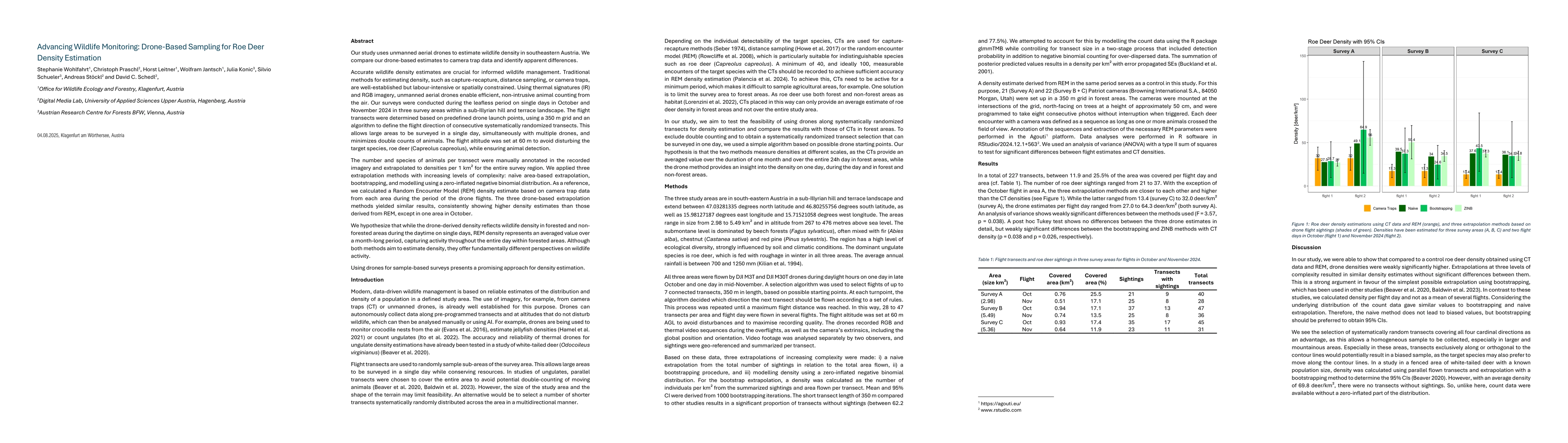
binomial modelling. For comparison, a Random Encounter Model (REM) estimate was calculated using camera trap data from the flight period. The drone-based methods yielded similar results, generally showing higher densities than REM, except in one area in October. We hypothesize that drone-based density reflects daytime activity in open and forested areas, while REM estimates average activity over longer periods within forested zones. Although both approaches estimate density, they offer different perspectives on wildlife presence. Our results show that drones offer a promising, scalable method for wildlife density estimation.
Key Findings, in focus
Seven facets of this paper, analysed and brought into focus by AI.
This research demonstrates that drone-based sampling offers a scalable, non-intrusive method for wildlife density estimation, providing insights into daily activity patterns that traditional methods like camera traps may miss.
- Drone-based methods consistently produced higher density estimates than REM, except in one October survey area.
- Extrapolation methods (naive, bootstrapping, and ZINB) yielded similar results, suggesting the simplest method is sufficient for reliable estimates.
- Drone surveys captured daytime activity across both forested and non-forested areas, while REM averaged activity over a month-long period in forested zones.
This research demonstrates that drone-based sampling offers a scalable, non-intrusive method for wildlife density estimation, providing insights into daily activity patterns that traditional methods like camera traps may miss. It supports more accurate and efficient wildlife monitoring for conservation and management.
The study introduces a systematic drone survey approach with randomized transects and multiple extrapolation methods, offering a robust framework for wildlife density estimation using thermal and RGB imagery.
This work is novel in its application of systematic drone transects combined with multiple extrapolation techniques for wildlife density estimation, and in highlighting the distinct temporal and spatial perspectives of drone-based versus camera trap methods.
- Drone surveys only captured data from a single day, potentially missing nocturnal activity.
- The study was limited to three specific areas in a sub-Illyrian landscape, restricting generalizability.
- Investigate the impact of extending drone surveys to night hours or twilight periods to better align with REM estimates.
- Test the effectiveness of drone-based methods in diverse habitats and larger study areas.
- Explore integration of AI for automated animal detection in drone footage to improve efficiency.
Discussion 0