Authors
Publication
Metrics
Quick Actions
AI Quick Summary
A new method for 3D reconstruction from aerial images improves depth estimation accuracy using adaptive range inference and normal cues, achieving state-of-the-art performance on several datasets.
Quick Answers
What is "Aerial Multi-View Stereo via Adaptive Depth Range Inference and Normal Cues" about?
A new method for 3D reconstruction from aerial images improves depth estimation accuracy using adaptive range inference and normal cues, achieving state-of-the-art performance on several datasets.
What methodology did the authors use?
The research proposes ADR-MVS, a method for aerial multi-view stereo that adapts depth range inference using monocular geometric cues. It introduces an adaptive depth range predictor (DRP) and a normal-guided cost aggregation (NCA) operation, along with a normal-guided depth refinement (NDR) module. More in Methodology →
What are the key results?
ADR-MVS outperforms state-of-the-art methods on WHU, LuoJia-MVS, and München datasets in terms of depth estimation accuracy. — The proposed DRP module improves feature-matching discriminability and mitigates convergence to local optima by breaking through predefined depth boundaries. More in Key Results →
Why is this work significant?
This research is significant as it addresses the unique challenges of aerial multi-view stereo, such as varying depth ranges and insensitive feature-matching in low-detailed aerial images, by integrating monocular geometric cues. The proposed ADR-MVS method offers improved depth estimation accuracy with competitive computational efficiency, which is crucial for large-scale urban 3D reconstruction from aerial imagery. More in Significance →
What are the main limitations?
The method's performance may be sensitive to the quality and resolution of aerial images. — The model's reliance on monocular cues might introduce errors in cases with severe textureless regions or significant height variations. More in Limitations →
Abstract
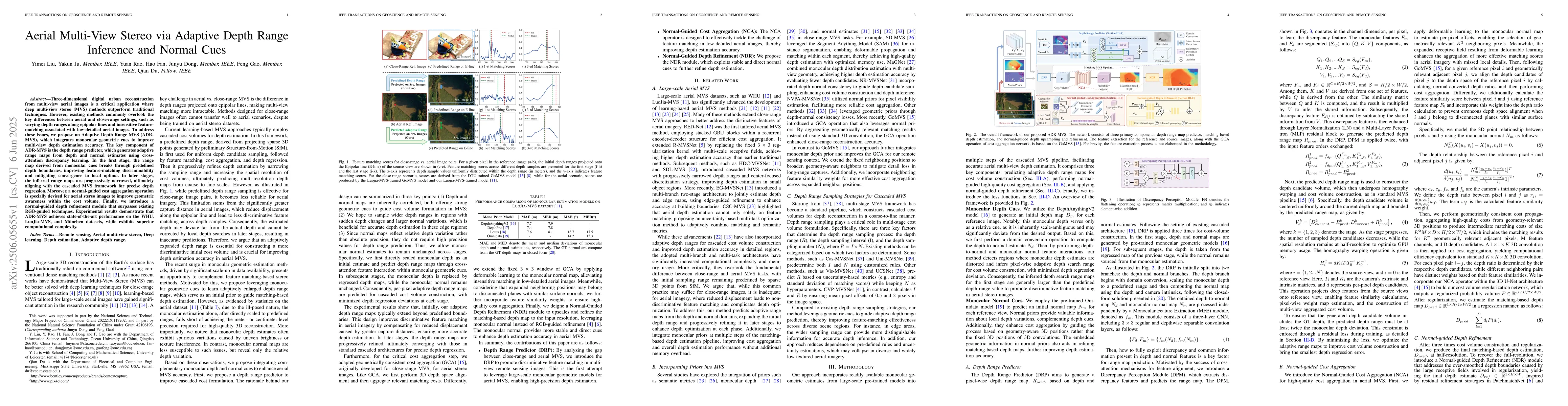
Three-dimensional digital urban reconstruction from multi-view aerial images is a critical application where deep multi-view stereo (MVS) methods outperform traditional techniques. However, existing methods commonly overlook the key differences between aerial and close-range settings, such as varying depth ranges along epipolar lines and insensitive feature-matching associated with low-detailed aerial images. To address these issues, we propose an Adaptive Depth Range MVS (ADR-MVS), which integrates monocular geometric cues to improve multi-view depth estimation accuracy. The key component of ADR-MVS is the depth range predictor, which generates adaptive range maps from depth and normal estimates using cross-attention discrepancy learning. In the first stage, the range map derived from monocular cues breaks through predefined depth boundaries, improving feature-matching discriminability and mitigating convergence to local optima. In later stages, the inferred range maps are progressively narrowed, ultimately aligning with the cascaded MVS framework for precise depth regression. Moreover, a normal-guided cost aggregation operation is specially devised for aerial stereo images to improve geometric awareness within the cost volume. Finally, we introduce a normal-guided depth refinement module that surpasses existing RGB-guided techniques. Experimental results demonstrate that ADR-MVS achieves state-of-the-art performance on the WHU, LuoJia-MVS, and M\"unchen datasets, while exhibits superior computational complexity.
AI Key Findings
Generated Sep 02, 2025
Methodology — What approach did the authors take?
The research proposes ADR-MVS, a method for aerial multi-view stereo that adapts depth range inference using monocular geometric cues. It introduces an adaptive depth range predictor (DRP) and a normal-guided cost aggregation (NCA) operation, along with a normal-guided depth refinement (NDR) module.
Key Results — What are the main findings?
- ADR-MVS outperforms state-of-the-art methods on WHU, LuoJia-MVS, and München datasets in terms of depth estimation accuracy.
- The proposed DRP module improves feature-matching discriminability and mitigates convergence to local optima by breaking through predefined depth boundaries.
- NCA enhances geometric awareness within the cost volume, and NDR surpasses existing RGB-guided techniques for depth refinement.
- ADR-MVS demonstrates superior computational complexity compared to existing methods.
- Ablation studies confirm the effectiveness of DRP, NCA, and NDR modules.
Significance — Why does this research matter?
This research is significant as it addresses the unique challenges of aerial multi-view stereo, such as varying depth ranges and insensitive feature-matching in low-detailed aerial images, by integrating monocular geometric cues. The proposed ADR-MVS method offers improved depth estimation accuracy with competitive computational efficiency, which is crucial for large-scale urban 3D reconstruction from aerial imagery.
Technical Contribution — What is the technical contribution?
The technical contributions of this work include the Adaptive Depth Range Predictor (ADR-MVS), which generates adaptive range maps using cross-attention discrepancy learning, and the Normal-Guided Cost Aggregation (NCA) and Normal-Guided Depth Refinement (NDR) modules, which improve geometric awareness and depth map quality, respectively.
Novelty — What is new about this work?
The novelty of this research lies in its tailored approach to aerial multi-view stereo, addressing the distinct characteristics of aerial imagery by incorporating monocular geometric cues and adaptive depth range inference, which sets it apart from traditional and existing close-range MVS methods.
Limitations — What are the limitations of this study?
- The method's performance may be sensitive to the quality and resolution of aerial images.
- The model's reliance on monocular cues might introduce errors in cases with severe textureless regions or significant height variations.
Future Work — What did the authors propose for future work?
- Investigate the method's performance on real-world datasets with varying aerial imaging conditions.
- Explore the integration of additional contextual information, such as semantic segmentation, to further enhance depth estimation accuracy.
Paper Details
How to Cite This Paper
@article{gao2025aerial,
title = {Aerial Multi-View Stereo via Adaptive Depth Range Inference and Normal
Cues},
author = {Gao, Feng and Fan, Hao and Dong, Junyu and others},
year = {2025},
eprint = {2506.05655},
archivePrefix = {arXiv},
primaryClass = {cs.CV},
}
Gao, F., Fan, H., Dong, J., Du, Q., Ju, Y., Liu, Y., & Rao, Y. (2025). Aerial Multi-View Stereo via Adaptive Depth Range Inference and Normal
Cues. arXiv. https://arxiv.org/abs/2506.05655
Gao, Feng, et al. "Aerial Multi-View Stereo via Adaptive Depth Range Inference and Normal
Cues." arXiv, 2025, arxiv.org/abs/2506.05655.
PDF Preview
Citation Network
Current paper (gray), citations (green), references (blue)
Display is limited for performance on very large graphs.
Similar Papers
Found 4 papersARAI-MVSNet: A multi-view stereo depth estimation network with adaptive depth range and depth interval
Song Zhang, Wenjia Xu, Zhiwei Wei et al.
Non-parametric Depth Distribution Modelling based Depth Inference for Multi-view Stereo
Miaomiao Liu, Jose M. Alvarez, Jiayu Yang
Cost Volume Pyramid Based Depth Inference for Multi-View Stereo
Jiayu Yang, Jose M. Alvarez, Wei Mao et al.
No citations found for this paper.
Comments (0)