We introduce AerialMetric, a new UAV-centric monocular metric depth benchmark comprising four complementary subsets: AerialMetric-Oblique (real-world oblique imagery with processed image-depth pairs), AerialMetric-Decoupled (controlled aerial acquisitions with varying viewpoints, FOVs, and altitudes), AerialMetric-Synthetic (photorealistic synthetic scenes with multi-angle viewpoints), and AerialMetric-Wild (in-the-wild Internet imagery). The dataset supports baseline evaluations of existing state-of-the-art monocular metric depth models and facilitates domain adaptation through fine-tuning on aerial data. Systematic experiments assess the impact of viewpoint, altitude, and camera parameters on depth prediction, and the authors fine-tune representative models on AerialMetric to establish an aerial benchmark and achieve state-of-the-art performance across diverse aerial imagery. The work also provides dataset and model weights publicly for reproducibility.
AerialMetric: Benchmarking and Adapting UAV Monocular Metric Depth Estimation in the Real World
Publication
Metrics
Quick Answers
What methodology did the authors use?
We introduce AerialMetric, a new UAV-centric monocular metric depth benchmark comprising four complementary subsets: AerialMetric-Oblique (real-world oblique imagery with processed image-depth pairs), AerialMetric-Decoupled (controlled aerial acquisitions with varying viewpoints, FOVs, and altitudes), AerialMetric-Synthetic (photorealistic synthetic scenes with multi-angle viewpoints), and AerialMetric-Wild (in-the-wild Internet imagery). The dataset supports baseline evaluations of existing state-of-the-art monocular metric depth models and facilitates domain adaptation... More in Methodology →
What are the key results?
AerialMetric reveals a significant domain gap between ground-level depth models and aerial viewpoints, with performance drops when models trained on street-view data are applied to UAV imagery. — Fine-tuning on AerialMetric substantially improves metric depth predictions for both aerial and ground-level scenes, achieving state-of-the-art results across diverse aerial imagery. More in Key Results →
Why is this work significant?
Provides the first large-scale, real-world and synthetic, metric-depth benchmark tailored to UAV imagery, enabling rigorous evaluation and adaptation of monocular depth models to aerial viewpoints and facilitating closer-to-realistic absolute scale estimation in the air domain. More in Significance →
What are the main limitations?
Potential biases due to dataset sources and synthetic-to-real transfer gaps that may affect generalization to unseen UAV platforms or sensor configurations. — Limitations in diversity of environmental conditions or flight patterns may restrict coverage of extreme viewpoints or lighting scenarios. More in Limitations →
Paper Preview
Abstract
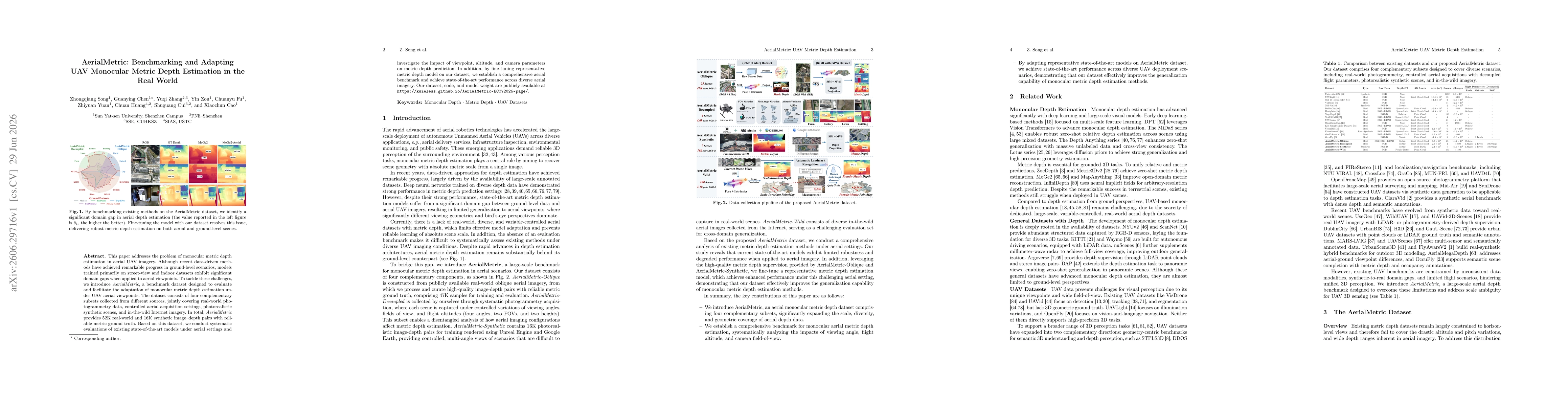
This paper addresses the problem of monocular metric depth estimation in aerial UAV imagery. Although recent data-driven methods have achieved remarkable progress in ground-level scenarios, models trained primarily on street-view and indoor datasets exhibit significant domain gaps when applied to aerial viewpoints. To tackle these challenges, we introduce AerialMetric, a benchmark dataset designed to evaluate and facilitate the adaptation of monocular metric depth estimation under UAV aerial viewpoints. The dataset consists of four complementary subsets collected from different sources, jointly covering real-world photogrammetry data, controlled aerial acquisition settings, photorealistic synthetic scenes, and in-the-wild Internet imagery. Totally, AerialMetric provides 52K real-world and 16K synthetic image-depth pairs with reliable metric ground truth. Based on this dataset, we conduct systematic evaluations of existing state-of-the-art models under aerial settings and investigate the impact of viewpoint, altitude, and camera parameters on metric depth prediction. In addition, by fine-tuning representative metric depth model on our dataset, we establish a comprehensive aerial benchmark and achieve state-of-the-art performance across diverse aerial imagery. Our dataset, code, and model weight are publicly available at https://kuieless.github.io/AerialMetric-ECCV2026-page/.
Key Findings, in focus
Seven facets of this paper, analysed and brought into focus by AI.
Provides the first large-scale, real-world and synthetic, metric-depth benchmark tailored to UAV imagery, enabling rigorous evaluation and adaptation of monocular depth models to aerial viewpoints and facilitating closer-to-realistic absolute scale estimation in the air domain.
- AerialMetric reveals a significant domain gap between ground-level depth models and aerial viewpoints, with performance drops when models trained on street-view data are applied to UAV imagery.
- Fine-tuning on AerialMetric substantially improves metric depth predictions for both aerial and ground-level scenes, achieving state-of-the-art results across diverse aerial imagery.
- Systematic analyses show that viewpoint, altitude, and camera parameters materially affect monocular metric depth estimation under UAV perspectives.
Provides the first large-scale, real-world and synthetic, metric-depth benchmark tailored to UAV imagery, enabling rigorous evaluation and adaptation of monocular depth models to aerial viewpoints and facilitating closer-to-realistic absolute scale estimation in the air domain.
AerialMetric provides a comprehensive UAV-focused monocular metric depth benchmark with 52K real-world and 16K synthetic image–depth pairs across four subsets, systematic evaluation protocols, and openly released code and model weights to promote reproducibility and model adaptation for aerial absolutescale depth estimation.
First large-scale, multi-source aerial monocular metric depth benchmark combining real-world, controlled, synthetic, and wild Internet imagery to study domain gaps, viewpoint effects, and model adaptation for UAV depth prediction.
- Potential biases due to dataset sources and synthetic-to-real transfer gaps that may affect generalization to unseen UAV platforms or sensor configurations.
- Limitations in diversity of environmental conditions or flight patterns may restrict coverage of extreme viewpoints or lighting scenarios.
- Explore more robust domain adaptation strategies to bridge residual gaps between ground-level and aerial depth estimation.
- Expand the benchmark with additional modalities (e.g., multi-view or stereo) and broader environmental conditions to improve generalization.
- Investigate lightweight models and real-time inference performance on embedded UAV hardware.
Discussion 0