Summary
Most seismic risk assessment methods focus on estimating the damages to the built environment and the consequent socioeconomic losses without fully taking into account the social aspect of risk. Yet, human behaviour is a key element in predicting the human impact of an earthquake, therefore, it is important to include it in quantitative risk assessment studies. In this study, an interdisciplinary approach simulating pedestrians' evacuation during earthquakes at the city scale is developed using an agent-based model. The model integrates the seismic hazard, the physical vulnerability as well as individuals' behaviours and mobility. The simulator is applied to the case of Beirut, Lebanon. Lebanon is at the heart of the Levant fault system that has generated several Mw>7 earthquakes, the latest being in 1759. It is one of the countries with the highest seismic risk in the Mediterranean region. This is due to the high seismic vulnerability of the buildings due to the absence of mandatory seismic regulation until 2012, the high level of urbanization, and the lack of adequate spatial planning and risk prevention policies. Beirut as the main residential, economic and institutional hub of Lebanon is densely populated. To accommodate the growing need for urban development, constructions have almost taken over all of the green areas of the city; squares and gardens are disappearing to give place to skyscrapers. However, open spaces are safe places to shelter, away from debris, and therefore play an essential role in earthquake evacuation. Despite the massive urbanization, there are a few open spaces but locked gates and other types of anthropogenic barriers often limit their access. To simulate this complex context, pedestrians' evacuation simulations are run in a highly realistic spatial environment implemented in GAMA [1]. Previous data concerning soil and buildings in Beirut [2, 3] are complemented by new geographic data extracted from high-resolution Pleiades satellite images. The seismic loading is defined as a peak ground acceleration of 0.3g, as stated in Lebanese seismic regulations. Building damages are estimated using an artificial neural network trained to predict the mean damage [4] based on the seismic loading as well as the soil and building vibrational properties [5]. Moreover, the quantity and the footprint of the generated debris around each building are also estimated and included in the model. We simulate how topography, buildings, debris, and access to open spaces, affect individuals' mobility. Two city configurations are implemented: 1. Open spaces are accessible without any barriers; 2. Access to some open spaces is blocked. The first simulation results show that while 52% of the population is able to arrive to an open space within 5 minutes after an earthquake, this number is reduced to 39% when one of the open spaces is locked. These results show that the presence of accessible open spaces in a city and their proximity to the residential buildings is a crucial factor for ensuring people's safety when an earthquake occurs.
AI Key Findings
Generated Sep 07, 2025
Methodology
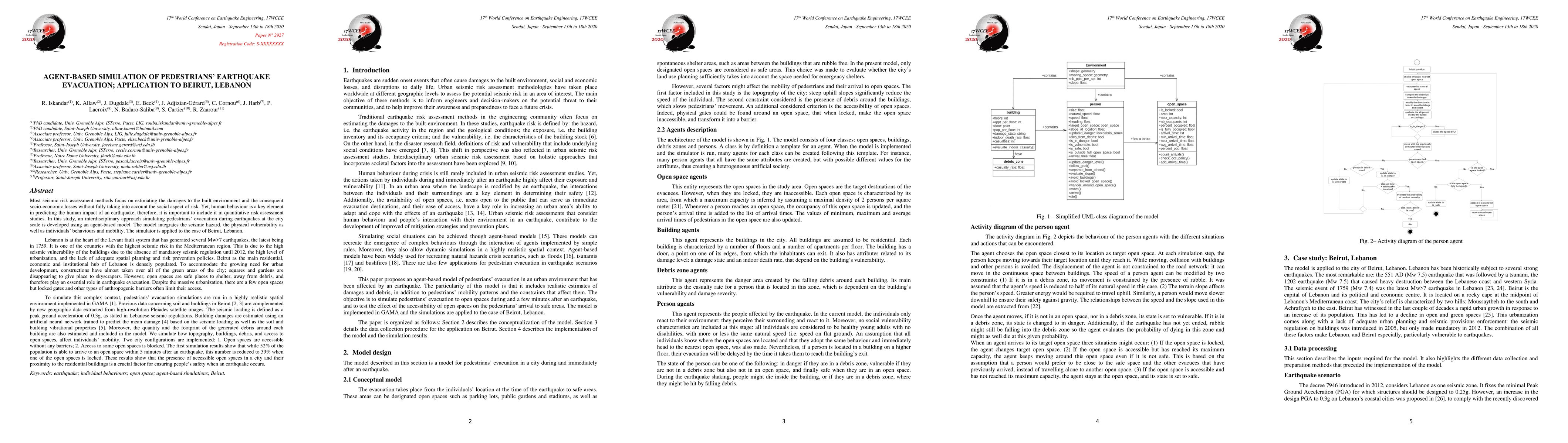
The research uses an agent-based model to simulate pedestrians' evacuation during earthquakes at the city scale, integrating seismic hazard, physical vulnerability, and individual behaviors and mobility. The model is applied to Beirut, Lebanon, using high-resolution satellite imagery and artificial neural networks to estimate building damages and debris footprints.
Key Results
- 52% of the population in Beirut can reach open spaces within 5 minutes after an earthquake when all open spaces are accessible.
- This rate drops to 39% when one open space is locked, highlighting the crucial role of accessible open spaces in ensuring people's safety during earthquakes.
- The simulation results emphasize the importance of open spaces' proximity to residential buildings for effective evacuation.
Significance
This study is significant as it integrates human behavior into quantitative risk assessment of earthquakes, focusing on pedestrian evacuation in a densely populated city like Beirut, which is highly vulnerable to seismic events.
Technical Contribution
The paper presents an interdisciplinary seismic risk model that integrates human behavior using an agent-based model, providing a comprehensive approach to pedestrian evacuation simulations in urban environments during and after earthquakes.
Novelty
This work stands out by focusing on the social aspect of risk in seismic risk assessment, employing a highly realistic spatial environment for simulations, and applying the model to Beirut, a city with high seismic vulnerability.
Limitations
- The model assumes simple assumptions that are currently being tested and will be progressively complicated for greater realism.
- The study lacks data on designated open spaces, requiring the digitization of 8 open spaces in the study area.
Future Work
- Future work will include incorporating social vulnerability attributes, cognition, and decision-making abilities into the pedestrian agents.
- Simulations will be extended to 15 minutes post-earthquake and expanded to cover the entire city of Beirut.
Paper Details
PDF Preview
Key Terms
Citation Network
Current paper (gray), citations (green), references (blue)
Display is limited for performance on very large graphs.
Similar Papers
Found 4 papersAn agent-based simulation model of pedestrian evacuation based on Bayesian Nash Equilibrium
Yiyu Wang, Jiaqi Ge, Alexis Comber
An Analysis of Pedestrians' Behavior in Emergency Evacuation Using Cellular Automata Simulation
Zhixuan Zhou, Huiyu Cai, Zhiguo Zhou
| Title | Authors | Year | Actions |
|---|
Comments (0)