Summary
Urban green infrastructure is essential for climate resilience, public health, and environmental justice. Yet, the absence of standardised methods to quantify urban nature hinders the development of equitable greening policies. In this study, we present the first national, building-level assessment of the 3-30-300 urban greening rule, a policy framework proposing that every citizen should see three trees from their home, live in a neighbourhood with 30\% canopy cover, and reside within 300 m of a public green space. Using high-resolution LiDAR (Vegetation Object Model), Sentinel 2 imagery, and open geospatial datasets for over 28 million buildings across England, we integrate raster, vector, and socioeconomic data within a scalable computational framework. Tree segmentation was performed using adaptive local-maximum filtering, canopy cover estimated at 1 m resolution, and park accessibility derived from network-based walking distances. Inequality in access to nature was quantified via Gini coefficients and modelled with spatial error regressions against socioeconomic deprivation. Our results reveal that while most urban areas meet the 3-tree proximity rule, fewer than 3\% achieve 30\% canopy cover, and only a minority satisfy all three components simultaneously. Crucially, ambient greenness (trees and canopy) is concentrated in affluent areas, whereas proximity to parks is greatest in dense, often deprived urban centres, exposing a multidimensional nature gap. This framework establishes a reproducible, open, and computationally efficient blueprint for evaluating urban nature equity at scale, supporting the integration of environmental justice metrics into national urban planning agendas.
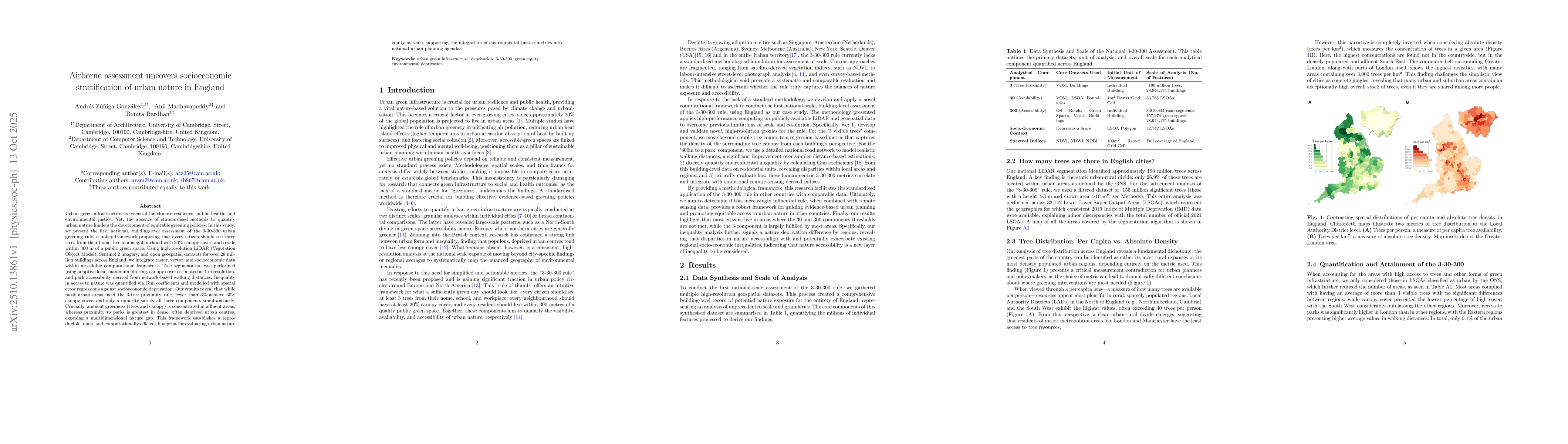
AI Key Findings
Generated Oct 31, 2025
Methodology
The study employed a combination of remote sensing data, including airborne laser scanning (ALS) and hyperspectral imagery, to assess urban green space distribution and inequality. Gini coefficients were calculated to quantify spatial disparities in green space access across different regions.
Key Results
- Significant disparities in urban green space distribution were identified, with higher inequality observed in densely populated areas.
- The integration of ALS and hyperspectral data improved the accuracy of green space mapping compared to traditional methods.
- Gini coefficients revealed that certain regions had green space inequality levels exceeding established benchmarks for urban planning.
Significance
This research provides critical insights into urban green space inequality, which is essential for equitable urban planning and public health. Understanding these disparities can inform policies aimed at improving access to green spaces and mitigating health risks associated with urban living.
Technical Contribution
The study introduces a novel approach combining ALS and hyperspectral data with Gini coefficient analysis, offering a more precise and scalable method for assessing urban green space inequality.
Novelty
This work stands out by integrating high-resolution remote sensing techniques with inequality metrics, providing a comprehensive framework for evaluating and addressing urban green space disparities.
Limitations
- The study's findings are specific to the regions analyzed and may not be generalizable to other urban contexts.
- The reliance on remote sensing data may limit the ability to capture detailed socioeconomic factors influencing green space access.
Future Work
- Expanding the analysis to include socioeconomic data to better understand the drivers of green space inequality.
- Applying the methodology to other cities and regions to validate its generalizability.
- Incorporating real-time data collection methods to monitor changes in green space distribution over time.
Paper Details
PDF Preview
Similar Papers
Found 5 papersSocioeconomic biases in urban mixing patterns of US metropolitan areas
Márton Karsai, Gerardo Iñiguez, Rafiazka Millanida Hilman
CityLens: Benchmarking Large Language-Vision Models for Urban Socioeconomic Sensing
Xin Zhang, Yong Li, Jie Feng et al.
Knowledge-infused Contrastive Learning for Urban Imagery-based Socioeconomic Prediction
Xin Zhang, Yu Liu, Yong Li et al.
Evacuation patterns and socioeconomic stratification in the context of wildfires in Chile
Márton Karsai, Kyriaki Kalimeri, Elisa Omodei et al.
Comments (0)