An Efficient Drifters Deployment Strategy to Evaluate Water Current Velocity Fields
Publication
Metrics
AI Quick Summary
This paper proposes a clustering-based strategy for deploying Lagrangian floaters to efficiently predict water current velocity fields, contrasting with the common random deployment method. The method segments the modeled velocity field and strategically places floaters to cover the entire area, demonstrating significant improvement in capturing in-homogeneous velocity distributions.
Paper Preview
Abstract
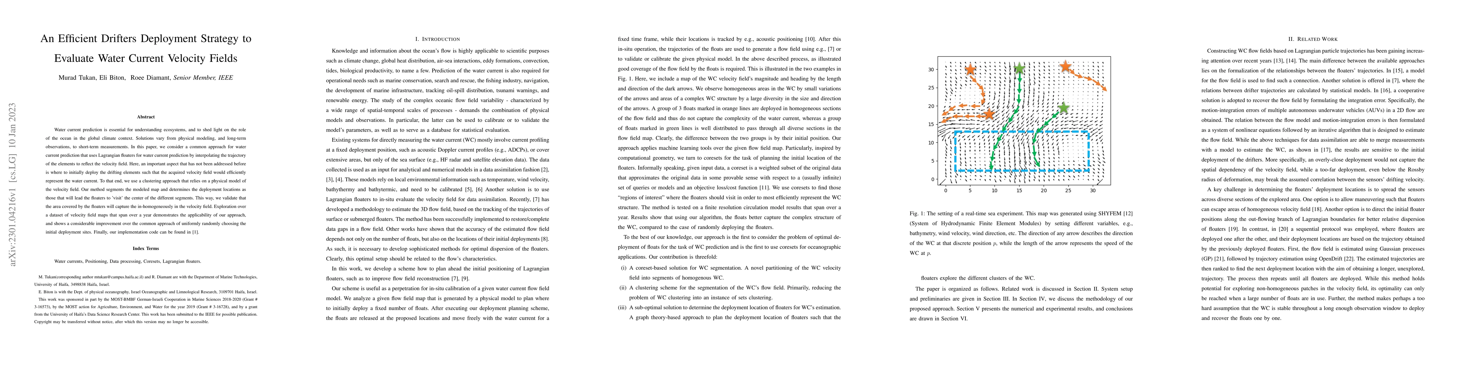
Water current prediction is essential for understanding ecosystems, and to shed light on the role of the ocean in the global climate context. Solutions vary from physical modeling, and long-term observations, to short-term measurements. In this paper, we consider a common approach for water current prediction that uses Lagrangian floaters for water current prediction by interpolating the trajectory of the elements to reflect the velocity field. Here, an important aspect that has not been addressed before is where to initially deploy the drifting elements such that the acquired velocity field would efficiently represent the water current. To that end, we use a clustering approach that relies on a physical model of the velocity field. Our method segments the modeled map and determines the deployment locations as those that will lead the floaters to 'visit' the center of the different segments. This way, we validate that the area covered by the floaters will capture the in-homogeneously in the velocity field. Exploration over a dataset of velocity field maps that span over a year demonstrates the applicability of our approach, and shows a considerable improvement over the common approach of uniformly randomly choosing the initial deployment sites. Finally, our implementation code can be found in [1].
AI Key Findings
Get AI-generated insights about this paper's methodology, results, significance, and more — seven facets brought into focus.
Impact
Paper Details
Authors
PDF Preview
Key Terms
Citation Network
Current paper (gray), citations (green), references (blue)
Display is limited for performance on very large graphs.
Discussion 0