Summary
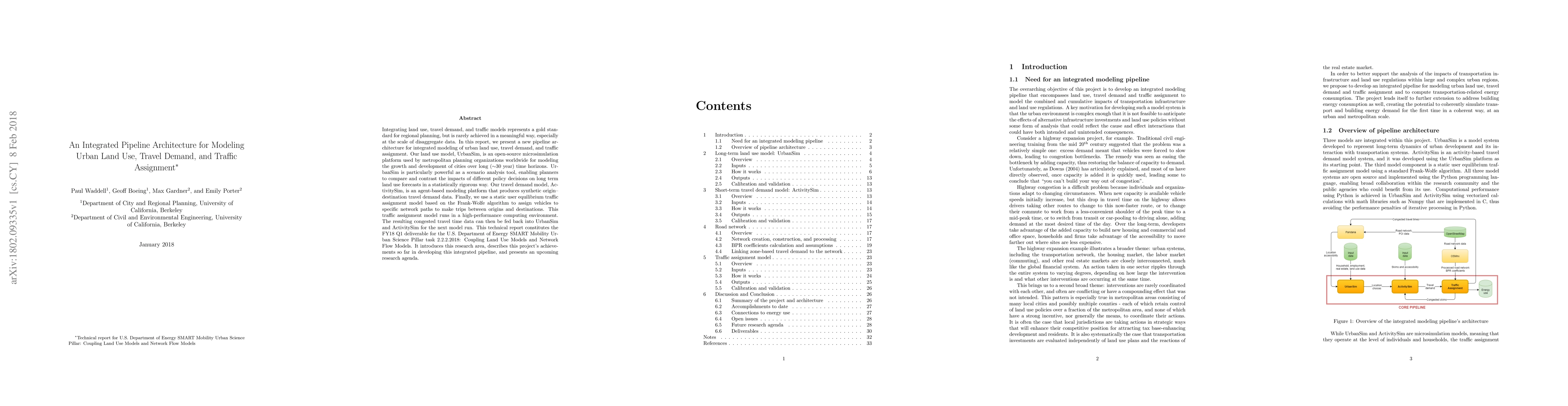
Integrating land use, travel demand, and traffic models represents a gold standard for regional planning, but is rarely achieved in a meaningful way, especially at the scale of disaggregate data. In this report, we present a new pipeline architecture for integrated modeling of urban land use, travel demand, and traffic assignment. Our land use model, UrbanSim, is an open-source microsimulation platform used by metropolitan planning organizations worldwide for modeling the growth and development of cities over long (~30 year) time horizons. UrbanSim is particularly powerful as a scenario analysis tool, enabling planners to compare and contrast the impacts of different policy decisions on long term land use forecasts in a statistically rigorous way. Our travel demand model, ActivitySim, is an agent-based modeling platform that produces synthetic origin--destination travel demand data. Finally, we use a static user equilibrium traffic assignment model based on the Frank-Wolfe algorithm to assign vehicles to specific network paths to make trips between origins and destinations. This traffic assignment model runs in a high-performance computing environment. The resulting congested travel time data can then be fed back into UrbanSim and ActivitySim for the next model run. This technical report introduces this research area, describes this project's achievements so far in developing this integrated pipeline, and presents an upcoming research agenda.
AI Key Findings
Get AI-generated insights about this paper's methodology, results, and significance.
Paper Details
PDF Preview
Key Terms
Citation Network
Current paper (gray), citations (green), references (blue)
Display is limited for performance on very large graphs.
Similar Papers
Found 4 papersOn the Use of Abundant Road Speed Data for Travel Demand Calibration of Urban Traffic Simulators
Iveel Tsogsuren, Neha Arora, Carolina Osorio et al.
Potential of on-demand services for urban travel
N. Geržinič, O. Cats, N. van Oort et al.
Deep autoregressive modeling for land use land cover
Christopher Krapu, Mark Borsuk, Ryan Calder
| Title | Authors | Year | Actions |
|---|
Comments (0)