An interdisciplinary data-science approach to managing natural hazards risk
Publication
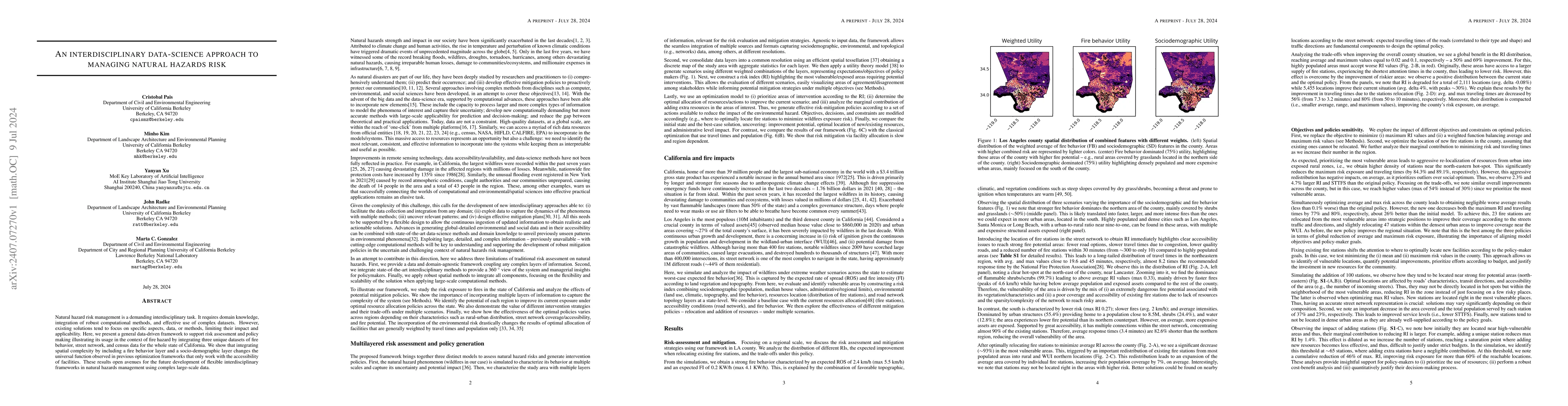
Metrics
AI Quick Summary
This paper introduces an interdisciplinary data-science framework for managing natural hazard risk, specifically illustrating its application in California's fire hazard context. The framework integrates fire behavior, street network, and census data, revealing that spatial complexity significantly alters risk assessment compared to previous methods.
Paper Preview
Abstract
Natural hazard risk management is a demanding interdisciplinary task. It requires domain knowledge, integration of robust computational methods, and effective use of complex datasets. However, existing solutions tend to focus on specific aspects, data, or methods, limiting their impact and applicability. Here, we present a general data-driven framework to support risk assessment and policy making illustrating its usage in the context of fire hazard by integrating three unique datasets of fire behavior, street network, and census data for the whole state of California. We show that integrating spatial complexity by including a fire behavior layer and a socio-demographic layer changes the universal function observed in previous optimization frameworks that only work with the accessibility of facilities. These results open avenues for the future development of flexible interdisciplinary frameworks in natural hazards management using complex large-scale data.
AI Key Findings
Get AI-generated insights about this paper's methodology, results, significance, and more — seven facets brought into focus.
Impact
Paper Details
Authors
PDF Preview
Citation Network
Current paper (gray), citations (green), references (blue)
Display is limited for performance on very large graphs.
Discussion 0