Background
Support Vector Machines (SVMs) are a family of nonparametric, supervised classifiers widely used in image analysis and land cover mapping. They handle nonlinear separability by mapping data into higher-dimensional feature spaces using kernel functions (e.g., linear, polynomial, Gaussian/RBF, sigmoid). The choice of kernel and its parameters (such as C, gamma, and polynomial degree) critically influence performance. Ensemble learning, or a committee of classifiers, seeks to improve robustness by combining diverse decision boundaries produced by different models, under the premise that diverse errors among members can be mitigated through collective voting.
Problem / Research Question
The paper asks whether an ensemble of SVM classifiers can improve land cover mapping accuracy compared with the best-performing single SVM. Specifically, it investigates a committee composed of linear SVM, Gaussian (RBF) SVM, and Quadratic SVM, aggregated via simple majority voting, to determine if diversity among kernels translates into higher accuracy and more reliable maps.
Innovation / Contribution
The key contribution is the empirical demonstration of an SVM ensemble applied to land cover mapping, using three kernel types to induce boundary diversity. The work ties ensemble theory to practical remote sensing: it shows that a majority-vote ensemble can enhance the classification output relative to linear and quadratic SVMs and can visually approximate the RBF SVM, which remains the top performer in this study. The discussion cites Polikar’s insights on diversity and risk reduction in ensembles, and suggests that increasing diversity could further improve results.
Methodology / Approach
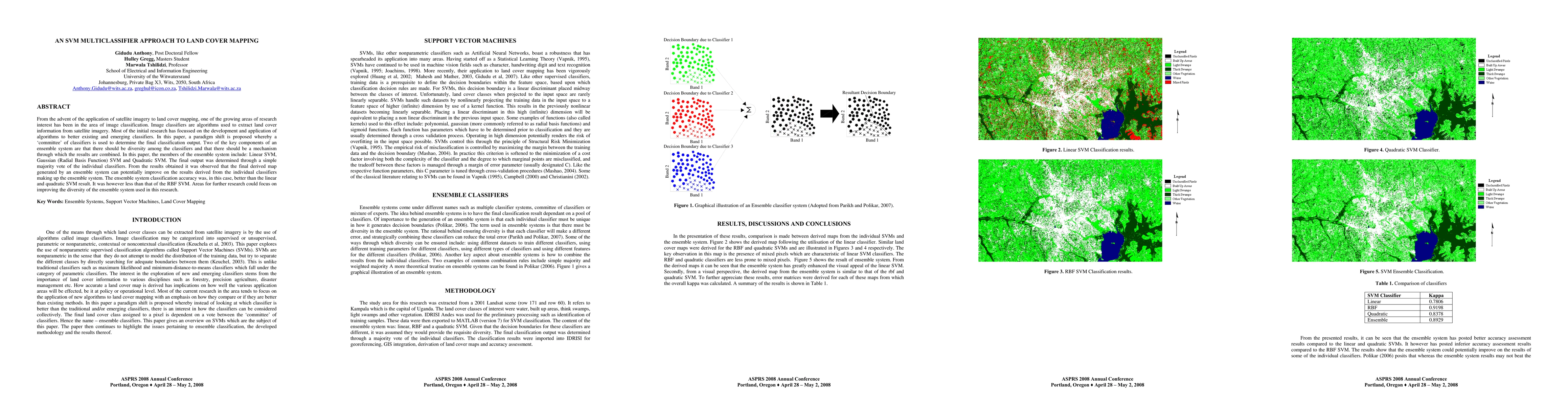
The study area is a 2001 Landsat scene over Kampala, Uganda. Land cover classes include water, built-up areas, thin swamps, light swamps, and other vegetation. Pre-processing and training sample identification were conducted in IDRISI Andes, with SVM training and classification in MATLAB (Version 7). The ensemble comprises three classifiers: Linear SVM, RBF SVM, and Quadratic SVM. A simple majority vote determines the final class for each pixel. The resulting classifications are georeferenced in IDRISI and subjected to accuracy assessment via confusion matrices and the kappa statistic.
Experiments / Evaluation
Results are presented as maps (Figures 2–5) and a table (Table 1) comparing classifier performance. The linear SVM produces notable mixed pixels, while RBF and Quadratic SVMs yield crisper boundaries. The ensemble map visually resembles the RBF and Quadratic maps and is reported to enhance the linear SVM’s appearance. Quantitatively, the kappa values are as follows: Linear 0.7806, RBF 0.9198, Quadratic 0.8378, Ensemble 0.8929. Thus, the ensemble outperforms the linear and quadratic classifiers but does not surpass the RBF SVM.
Key Results
- Ensemble accuracy (kappa) = 0.8929, higher than Linear (0.7806) and Quadratic (0.8378).
- RBF SVM remains the strongest single classifier with kappa = 0.9198.
- Visual analysis suggests the ensemble mitigates mixed-pixel issues seen with linear SVM and produces maps similar in quality to the RBF/Quadratic SVM outputs.
- The authors note that ensemble approaches can reduce the risk of selecting a poor single classifier and advocate for increasing diversity to further improve performance.
Practical Applications
The proposed ensemble approach offers a robust alternative for land cover mapping in operational settings where data heterogeneity and boundary ambiguity are common. Because the method leverages existing algorithms (three SVM kernels) and uses a straightforward majority vote, it can be integrated into GIS workflows with moderate retooling. The approach is particularly useful for organizations seeking improved map reliability without resorting to more complex or opaque models, and it provides a framework for combining SVMs across different study areas or sensor datasets.
Limitations & Considerations
Key limitations include the ensemble not beating the best single model (RBF SVM) in this study, suggesting that diversity may need to be increased or combined in smarter ways (e.g., weighted voting, stacking). The paper emphasizes diversity as central to ensemble gains, but the chosen three classifiers may not provide sufficient heterogeneity in all contexts. Additional details on kernel parameter tuning (C, gamma, polynomial degree), cross-validation procedures, dataset size, and class imbalance are not exhaustively reported, limiting reproducibility. Further work should explore other classifiers, more sophisticated combination rules, and evaluation across varied landscapes and sensor data to assess generalizability and scalability.
Discussion 0