Summary
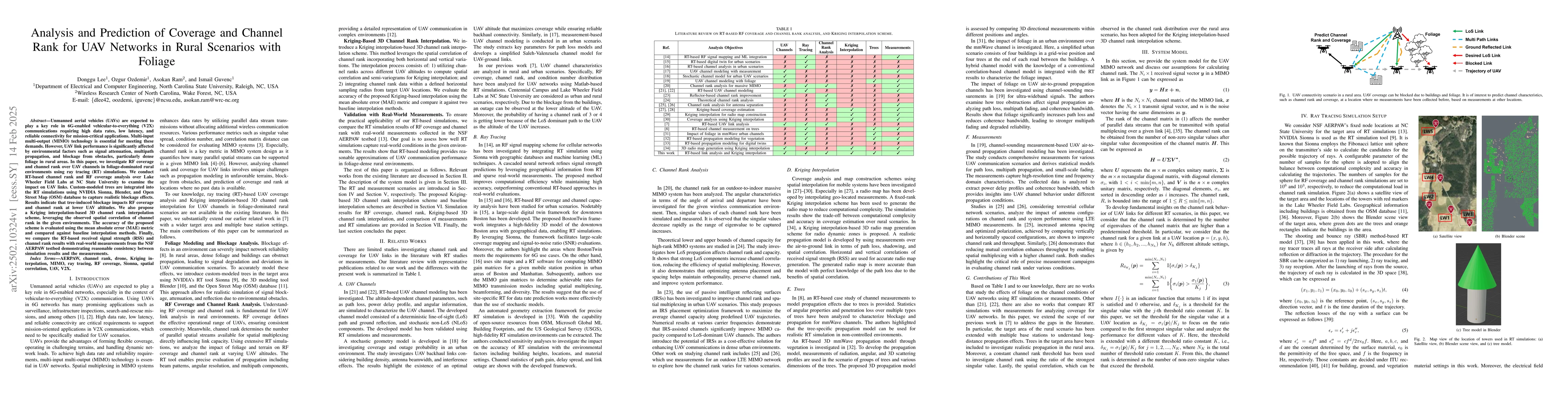
Unmanned aerial vehicles (UAVs) are expected to play a key role in 6G-enabled vehicular-to-everything (V2X) communications requiring high data rates, low latency, and reliable connectivity for mission-critical applications. Multi-input multi-output (MIMO) technology is essential for meeting these demands. However, UAV link performance is significantly affected by environmental factors such as signal attenuation, multipath propagation, and blockage from obstacles, particularly dense foliage in rural areas. In this paper, we investigate RF coverage and channel rank over UAV channels in foliage-dominated rural environments using ray tracing (RT) simulations. We conduct RT-based channel rank and RF coverage analysis over Lake Wheeler Field Labs at NC State University to examine the impact on UAV links. Custom-modeled trees are integrated into the RT simulations using NVIDIA Sionna, Blender, and Open Street Map (OSM) database to capture realistic blockage effects. Results indicate that tree-induced blockage impacts RF coverage and channel rank at lower UAV altitudes. We also propose a Kriging interpolation-based 3D channel rank interpolation scheme, leveraging the observed spatial correlation of channel rank in the given environments. The accuracy of the proposed scheme is evaluated using the mean absolute error (MAE) metric and compared against baseline interpolation methods. Finally, we compare the RT-based received signal strength (RSS) and channel rank results with real-world measurements from the NSF AERPAW testbed demonstrating reasonable consistency between simulation results and the measurements.
AI Key Findings
Generated Jun 11, 2025
Methodology
The study uses ray tracing simulations with NVIDIA Sionna, Blender, and Open Street Map (OSM) to model UAV channels in foliage-dominated rural environments, incorporating realistic tree blockage effects.
Key Results
- Tree-induced blockage significantly impacts RF coverage and channel rank at lower UAV altitudes.
- A Kriging interpolation-based 3D channel rank interpolation scheme was proposed, leveraging spatial correlation of channel rank.
- The proposed interpolation scheme outperformed baseline methods in terms of mean absolute error (MAE) for channel rank prediction.
- RT-based RSS and channel rank results showed reasonable consistency with real-world measurements from the NSF AERPAW testbed.
- The study identified that blockage effects are mitigated at higher UAV altitudes, and MIMO configurations tend to have wider RSS ranges due to multiple directional beams.
Significance
This research is crucial for understanding and predicting UAV link performance in challenging rural environments with dense foliage, which is essential for 6G-enabled V2X communications requiring high data rates, low latency, and reliable connectivity.
Technical Contribution
The paper presents a novel Kriging interpolation-based 3D channel rank prediction scheme, which leverages spatial correlation to improve accuracy in predicting UAV link performance in foliage-rich rural environments.
Novelty
The work distinguishes itself by incorporating realistic foliage modeling, multiple base stations, and a Kriging interpolation-based 3D channel rank prediction scheme, providing a more comprehensive analysis of UAV channel characteristics in rural settings.
Limitations
- The study was limited to specific rural scenarios with foliage and may not generalize to all UAV communication environments.
- Real-world measurements were compared, but discrepancies due to factors like angular mismatches, dynamic vs. static environments, and rank calculation differences were noted.
Future Work
- Further research could focus on managing time-varying channel characteristics in UAV-based 6G and V2X communications.
- Optimizing spatial multiplexing under dynamic network conditions could be explored to enhance reliability and efficiency.
Paper Details
PDF Preview
Similar Papers
Found 4 papersRank and Condition Number Analysis for UAV MIMO Channels Using Ray Tracing
Ismail Guvenc, Donggu Lee
No citations found for this paper.
Comments (0)