This research investigates the impact of incorporating intra-annual NDVI data with annual multi-spectral data for improved poverty estimation in low- and middle-income countries. Results show that integrating such granular time-series information enhances model accuracy and highlights the importance of intra-annual variations, particularly in agricultural regions.
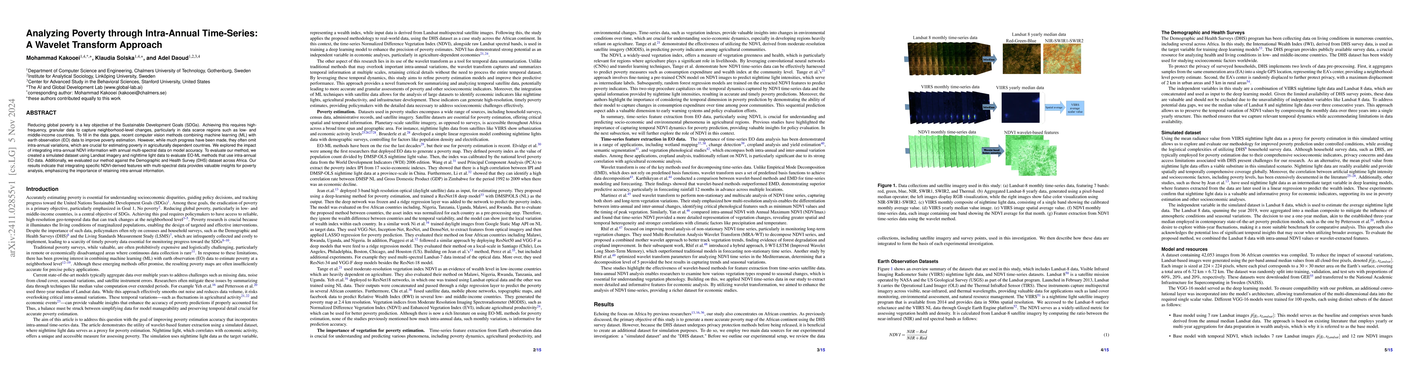
Reducing global poverty is a key objective of the Sustainable Development Goals (SDGs). Achieving this requires high-frequency, granular data to capture neighborhood-level changes, particularly in data scarce regions such as low- and middle-income countries. To fill in the data gaps, recent computer vision methods combining machine learning (ML) with earth observation (EO) data to improve poverty estimation. However, while much progress have been made, they often omit intra-annual variations, which are crucial for estimating poverty in agriculturally dependent countries. We explored the impact of integrating intra-annual NDVI information with annual multi-spectral data on model accuracy. To evaluate our method, we created a simulated dataset using Landsat imagery and nighttime light data to evaluate EO-ML methods that use intra-annual EO data. Additionally, we evaluated our method against the Demographic and Health Survey (DHS) dataset across Africa. Our results indicate that integrating specific NDVI-derived features with multi-spectral data provides valuable insights for poverty analysis, emphasizing the importance of retaining intra-annual information.
Get AI-generated insights about this paper's methodology, results, and significance.
Current paper (gray), citations (green), references (blue)
No similar papers found for this research.
Title | Authors | Year | Actions |
---|---|---|---|
A Scoping Review of Earth Observation and Machine Learning for Causal Inference: Implications for the Geography of Poverty
|
Kazuki Sakamoto, Connor T. Jerzak, Adel Daoud
|
2024
|
View Paper |
Title | Authors | Year | Actions |
---|---|---|---|
Epileptic Seizure Classification Based on Random Neural Networks Using Discrete Wavelet Transform for Electroencephalogram Signal Decomposition
|
Syed Yaseen Shah, Hadi Larijani, Ryan M. Gibson, Dimitrios Liarokapis
|
2024
|
View Paper |
Time Series of Satellite Imagery Improve Deep Learning Estimates of Neighborhood-Level Poverty in Africa
|
Markus B. Pettersson, Mohammad Kakooei, Julia Ortheden, Fredrik D. Johansson, Adel Daoud
|
2023
|
View Paper |
Wetland Mapping in Great Lakes Using Sentinel-1/2 Time-Series Imagery and DEM Data in Google Earth Engine
|
Farzane Mohseni, M. Amani, Pegah Mohammadpour, Mohammad Kakooei, Shuanggen Jin, Armin Moghimi
|
2023
|
View Paper |
Using Satellite Images and Deep Learning to Measure Health and Living Standards in India
|
Adel Daoud, Felipe Jordán, Makkunda Sharma, F. Johansson, Devdatt P. Dubhashi, S. Paul, Subhashis Banerjee
|
2023
|
View Paper |
Optimal selection of wavelet transform parameters for spatio-temporal analysis based on non-stationary NDVI MODIS time series in Mediterranean region
|
M. Rhif, A. Ben Abbes, B. Martínez, I. Farah, M. Gilabert
|
2022
|
View Paper |
Forty Years of Wetland Status and Trends Analyses in the Great Lakes Using Landsat Archive Imagery and Google Earth Engine
|
M. Amani, Mohammad Kakooei, A. Ghorbanian, Rebecca K. Warren, S. Mahdavi, B. Brisco, Armin Moghimi, L. Bourgeau-Chavez, S. Touré, Ambika Paudel, Ablajan Sulaiman, Richard Post
|
2022
|
View Paper |
Comparison of time-integrated NDVI and annual maximum NDVI for assessing grassland dynamics
|
Junjie Yan, Guangpeng Zhang, Hongbo Ling, Feifei Han
|
2022
|
View Paper |
Personalized Public Policy Analysis in Social Sciences using Causal-Graphical Normalizing Flows
|
Sourabh Vivek Balgi, J. Peña, Adel Daoud
|
2022
|
View Paper |
Predicting poverty with vegetation index
|
Binh Tang, Yanyan Liu, David S. Matteson
|
2021
|
View Paper |
Cotton yield estimation model based on machine learning using time series UAV remote sensing data
|
Weicheng Xu, Pengchao Chen, Yilong Zhan, Shengde Chen, Lei Zhang, Y. Lan
|
2021
|
View Paper |
An Investigation on Deep Learning Approaches to Combining Nighttime and Daytime Satellite Imagery for Poverty Prediction
|
Ye Ni, Xutao Li, Yunming Ye, Yan Li, Chunshan Li, Dianhui Chu
|
2021
|
View Paper |
A scoping review on the use of machine learning in research on social determinants of health: Trends and research prospects
|
S. Kino, Yu-Tien Hsu, K. Shiba, Y. Chien, C. Mita, I. Kawachi, Adel Daoud
|
2021
|
View Paper |
Microestimates of wealth for all low- and middle-income countries
|
Guanghua Chi, Han Fang, S. Chatterjee, J. Blumenstock
|
2021
|
View Paper |
Statistical modeling: the three cultures
|
Adel Daoud, Devdatt P. Dubhashi
|
2020
|
View Paper |
An improved trend vegetation analysis for non-stationary NDVI time series based on wavelet transform
|
M. Rhif, A. Ben Abbes, B. Martínez, I. Farah
|
2020
|
View Paper |
Google Earth Engine Cloud Computing Platform for Remote Sensing Big Data Applications: A Comprehensive Review
|
Arsalan Ghorbanian Seyed, Ali Ahmadi, Mohammad Kakooei, Armin Moghimi, S. M. I. S. Mohammad Mirmazloumi, Sayyed Hamed, Alizadeh Moghaddam, S. Mahdavi, Masoud Ghahremanloo, Saeid Parsian, Qiusheng Wu, B. Brisco, S.MohammadMirmazloumiis, MasoudGhahremanloo
|
2020
|
View Paper |
Efficient Poverty Mapping using Deep Reinforcement Learning
|
Kumar Ayush, Burak Uzkent, M. Burke, D. Lobell, Stefano Ermon
|
2020
|
View Paper |
Using publicly available satellite imagery and deep learning to understand economic well-being in Africa
|
Christopher Yeh, Anthony Perez, Anne Driscoll, G. Azzari, Zhongyi Tang, D. Lobell, Stefano Ermon, M. Burke
|
2020
|
View Paper |
A review of vegetation phenological metrics extraction using time-series, multispectral satellite data
|
Linglin Zeng, B. Wardlow, D. Xiang, Shun Hu, Deren Li
|
2020
|
View Paper |
Using satellite imagery to understand and promote sustainable development
|
M. Burke, Anne Driscoll, D. Lobell, Stefano Ermon
|
2019
|
View Paper |
Estimation of Poverty Using Random Forest Regression with Multi-Source Data: A Case Study in Bangladesh
|
Xizhi Zhao, Bailang Yu, Yan Liu, Zuoqi Chen, Qiaoxuan Li, Congxiao Wang, Jianping Wu
|
2019
|
View Paper |
A spatiotemporal calculus for reasoning about land-use trajectories
|
A. Maciel, G. Câmara, L. Vinhas, M. Picoli, R. Begotti, L. F. F. G. D. Assis
|
2018
|
View Paper |
THE GLOBAL DISTRIBUTION OF ECONOMIC ACTIVITY: NATURE, HISTORY, AND THE ROLE OF TRADE.
|
V. Henderson, Timothy L. Squires, A. Storeygard, D. Weil
|
2018
|
View Paper |
Comparative study of three satellite image time-series decomposition methods for vegetation change detection
|
A. Ben Abbes, Oumayma Bounouh, I. Farah, Rogier de Jong, B. Martínez
|
2018
|
View Paper |
Poverty Prediction with Public Landsat 7 Satellite Imagery and Machine Learning
|
Anthony Perez, Christopher Yeh, G. Azzari, M. Burke, D. Lobell, Stefano Ermon
|
2017
|
View Paper |
Nighttime lights as a proxy for human development at the local level
|
Anna Bruederle, R. Hodler
|
2017
|
View Paper |
Sustainable Development Goals
|
Ruth Oniang'o
|
2016
|
View Paper |
Combining satellite imagery and machine learning to predict poverty
|
Neal Jean, M. Burke, Sang Michael Xie, W. Davis, D. Lobell, Stefano Ermon
|
2016
|
View Paper |
What Is the Association between Absolute Child Poverty, Poor Governance, and Natural Disasters? A Global Comparison of Some of the Realities of Climate Change
|
Adel Daoud, Björn Halleröd, D. Guha-Sapir
|
2016
|
View Paper |
Deep Residual Learning for Image Recognition
|
Kaiming He, X. Zhang, Shaoqing Ren, Jian Sun
|
2015
|
View Paper |
The International Wealth Index (IWI)
|
J. Smits, Roel Steendijk
|
2015
|
View Paper |
Poverty, health and satellite-derived vegetation indices: their inter-spatial relationship in West Africa.
|
Luigi Sedda, A. Tatem, David Morley, P. Atkinson, N. Wardrop, C. Pezzulo, A. Sorichetta, Joanna Kuleszo, D. Rogers
|
2015
|
View Paper |
Google Earth Engine
|
D. Thau
|
2015
|
View Paper |
The Political Economy of Bad Data: Evidence from African Survey and Administrative Statistics
|
J. Sandefur, A. Glassman
|
2015
|
View Paper |
Environmental Risk Factors and Child Nutritional Status and Survival in a Context of Climate Variability and Change
|
Kiersten L Johnson, Molly E. Brown
|
2014
|
View Paper |
Very Deep Convolutional Networks for Large-Scale Image Recognition
|
K. Simonyan, Andrew Zisserman
|
2014
|
View Paper |
Using Nighttime Satellite Imagery as a Proxy Measure of Human Well-Being
|
T. Ghosh, S. Anderson, C. Elvidge, P. Sutton
|
2013
|
View Paper |
Predictability of nonstationary time series using wavelet and EMD based ARMA models
|
Nagesh Kumar, L. Karthikeyan, D. Kumar
|
2013
|
View Paper |
Detecting Zimbabwe's Decadal Economic Decline Using Nighttime Light Imagery
|
Xi Li, L. Ge, Xiaoling Chen
|
2013
|
View Paper |
Geographic displacement procedure and georeferenced data release policy for the Demographic and Health Surveys.
|
Clara R. Burgert, Josh M. Colston, Thea Roy, Blake Zachary
|
2013
|
View Paper |
Visible Infrared Imaging Radiometer Suits(VIIRS)による漁火観測
|
市男 浅沼
|
2013
|
View Paper |
Feature Extraction and Reduction of Wavelet Transform Coefficients for EMG Pattern Classification
|
A. Phinyomark, A. Nuidod, P. Phukpattaranont, C. Limsakul
|
2012
|
View Paper |
Poverty assessment using DMSP/OLS night-time light satellite imagery at a provincial scale in China
|
Wen Wang, Huihua Cheng, Li Zhang
|
2012
|
View Paper |
Vegetation dynamics from NDVI time series analysis using the wavelet transform
|
B. Martínez, M. Gilabert
|
2009
|
View Paper |
A global poverty map derived from satellite data
|
C. Elvidge, P. Sutton, T. Ghosh, B. Tuttle, K. Baugh, B. Bhaduri, E. Bright
|
2009
|
View Paper |
Measuring Economic Growth from Outer Space
|
J. Henderson, A. Storeygard, D. Weil
|
2009
|
View Paper |
Increasing the Confidence of Predictive Uncertainty: Earth Observations and Deep Learning for Poverty Estimation
|
Mohammad Kakooei, Adel Daoud
|
2024
|
View Paper |
Demographic and Health Surveys Program
|
2023
|
||
Classification of Different Irrigation Systems at Field Scale Using Time-Series of Remote Sensing Data
|
G. Paolini, M. Escorihuela, O. Merlin, Magi Pamies Sans, Joaquim Bellvert
|
2022
|
View Paper |
A Saturated Light Correction Method for DMSP-OLS Nighttime Stable Light Data by Remote and Social Sensing Data
|
Xiaolei Huang, Kaifang Shi, Yuanzheng Cui, Yuanqing Li
|
2021
|
View Paper |
Wetland Change Analysis in Alberta, Canada Using Four Decades of Landsat Imagery
|
M. Amani, S. Mahdavi, Mohammad Kakooei, A. Ghorbanian, B. Brisco, Evan R. DeLancey, S. Touré, Eugenio Landeiro Reyes
|
2021
|
View Paper |
An Improved Forecasting Model from Satellite Imagery Based on Optimum Wavelet Bases and Adam Optimized LSTM Methods
|
M. Rhif, Ali Ben Abbes, Beatriz Martínez, I. Farah
|
2021
|
View Paper |
Predicting City Poverty Using Satellite Imagery
|
Simone Piaggesi, L. Gauvin, M. Tizzoni, C. Cattuto, N. Adler, S. Verhulst, Andrew Young, R. Price, L. Ferres, A. Panisson
|
2019
|
View Paper |
Wavelet Denoising and Singular Value Decomposition-based Methods for Signal Processing in Electron Spin Resonance Spectroscopy
|
2018
|
||
Data for development: A needs assessment for SDG monitoring and statistical capacity development (Sustainable Development Solutions Network
|
2015
|
||
Using machine learning to assess the livelihood impact of electricity access
|
|||
Landsat Missions
|
|||
Living Standards Measurement Study
|
Showing first page preview. Click "Open Full PDF" to view the complete paper.
Your comment contains inappropriate language and has been rejected.
Are you sure you want to remove this tag? This action cannot be undone.
Someone just favorited a paper!
Comments (0)