Publication

Published: Apr 07, 2026
Categories: cs.RO, cs.CV

Metrics

Source: ArXiv

Quick Actions

View PDF

Quick Answers

What methodology did the authors use?

The authors design a training‑free, semantic‑to‑geometric cascade that first builds dense pixel‑level relevance maps to guide frontier exploration, then invokes a 3D multi‑view foundation model only when a semantic proximity threshold is exceeded, enabling self‑certified 6‑DoF pose registration. More in Methodology →

What are the key results?

Achieves state‑of‑the‑art success rates of 93.1% on Gibson and 82.6% on HM3D, surpassing prior baselines — Provides precise pose recovery with 0.27 m position error and 3.41° heading error on Gibson, and 0.21 m / 1.23° on HM3D, a 5–10× improvement More in Key Results →

Why is this work significant?

Demonstrates that precise image‑goal navigation can be achieved without training, bridging the gap to manipulation‑ready localization and enabling robots to act on image‑specified goals. More in Significance →

What are the main limitations?

Relies on depth and odometry sensors for BEV map construction, limiting applicability to RGB‑only setups — Failure modes include goal not found due to lack of semantic relevance and sensitivity of confidence thresholds More in Limitations →

Paper Preview

Abstract

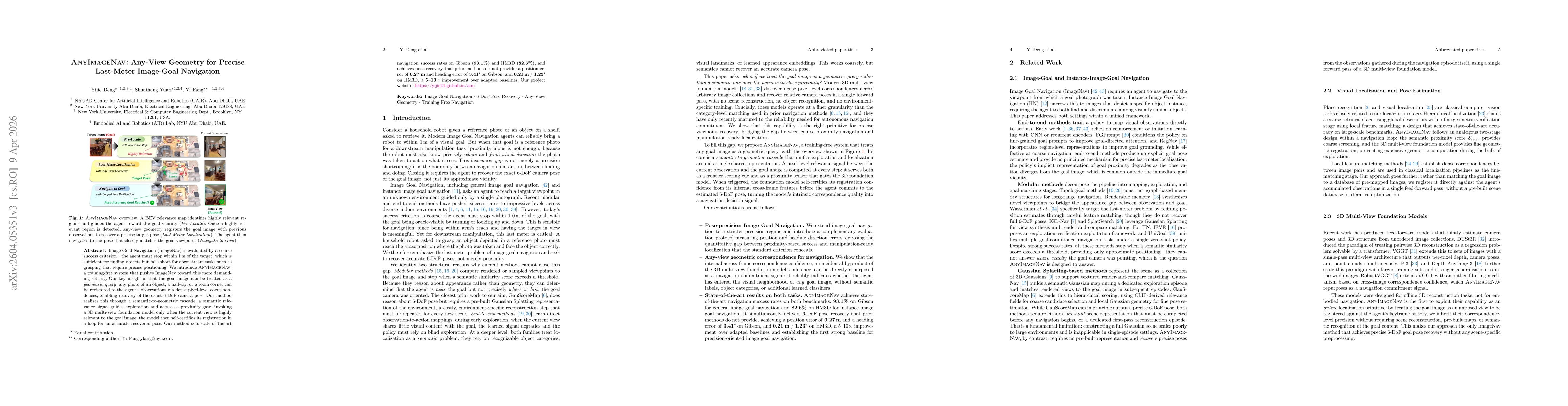
Image Goal Navigation (ImageNav) is evaluated by a coarse success criterion, the agent must stop within 1m of the target, which is sufficient for finding objects but falls short for downstream tasks such as grasping that require precise positioning. We introduce AnyImageNav, a training-free system that pushes ImageNav toward this more demanding setting. Our key insight is that the goal image can be treated as a geometric query: any photo of an object, a hallway, or a room corner can be registered to the agent's observations via dense pixel-level correspondences, enabling recovery of the exact 6-DoF camera pose. Our method realizes this through a semantic-to-geometric cascade: a semantic relevance signal guides exploration and acts as a proximity gate, invoking a 3D multi-view foundation model only when the current view is highly relevant to the goal image; the model then self-certifies its registration in a loop for an accurate recovered pose. Our method sets state-of-the-art navigation success rates on Gibson (93.1%) and HM3D (82.6%), and achieves pose recovery that prior methods do not provide: a position error of 0.27m and heading error of 3.41 degrees on Gibson, and 0.21m / 1.23 degrees on HM3D, a 5-10x improvement over adapted baselines.

AI Key Findings

Generated Apr 09, 2026

Methodology — What approach did the authors take?

The authors design a training‑free, semantic‑to‑geometric cascade that first builds dense pixel‑level relevance maps to guide frontier exploration, then invokes a 3D multi‑view foundation model only when a semantic proximity threshold is exceeded, enabling self‑certified 6‑DoF pose registration.

Key Results — What are the main findings?

  • Achieves state‑of‑the‑art success rates of 93.1% on Gibson and 82.6% on HM3D, surpassing prior baselines
  • Provides precise pose recovery with 0.27 m position error and 3.41° heading error on Gibson, and 0.21 m / 1.23° on HM3D, a 5–10× improvement
  • Introduces a confidence‑monitored refinement loop that continuously updates the best pose estimate, improving both success and precision

Significance — Why does this research matter?

Demonstrates that precise image‑goal navigation can be achieved without training, bridging the gap to manipulation‑ready localization and enabling robots to act on image‑specified goals.

Technical Contribution — What is the technical contribution?

A semantic‑to‑geometric cascade that uses dense pixel‑level relevance maps for exploration and a 3D multi‑view foundation model for self‑certified pose registration, enabling training‑free, precise last‑meter navigation.

Novelty — What is new about this work?

Treating the goal image as a geometric query and self‑certifying registration via a foundation model, combined with relevance‑guided frontier exploration, is novel compared to prior semantic‑only or training‑based methods.

Limitations — What are the limitations of this study?

  • Relies on depth and odometry sensors for BEV map construction, limiting applicability to RGB‑only setups
  • Failure modes include goal not found due to lack of semantic relevance and sensitivity of confidence thresholds

Future Work — What did the authors propose for future work?

  • Develop sensor‑light or RGB‑only methods to replace depth/odometry, possibly via robust 3D foundation models
  • Incorporate scene‑level priors or adaptive thresholds to reduce goal‑not‑found and premature acceptance failures

Paper Details

Paper ID: 2604.05351
Categories:
cs.RO cs.CV

How to Cite This Paper

BibTeX
@article{yuan2026anyimagenav,
  title         = {AnyImageNav: Any-View Geometry for Precise Last-Meter Image-Goal Navigation},
  author        = {Yuan, Shuaihang and Fang, Yi and Deng, Yijie},
  year          = {2026},
  eprint        = {2604.05351},
  archivePrefix = {arXiv},
  primaryClass  = {cs.RO},
}
APA 7
Yuan, S., Fang, Y., & Deng, Y. (2026). AnyImageNav: Any-View Geometry for Precise Last-Meter Image-Goal Navigation. arXiv. https://arxiv.org/abs/2604.05351
MLA 9
Yuan, Shuaihang, et al. "AnyImageNav: Any-View Geometry for Precise Last-Meter Image-Goal Navigation." arXiv, 2026, arxiv.org/abs/2604.05351.

Similar Papers

Found 4 papers

FGPrompt: Fine-grained Goal Prompting for Image-goal Navigation

Xinyu Sun, Peihao Chen, Jugang Fan et al.

2023-10-12

RSRNav: Reasoning Spatial Relationship for Image-Goal Navigation

Zheng Qin, Le Wang, Yabing Wang et al.

2025-04-25

Topological Semantic Graph Memory for Image-Goal Navigation

Nuri Kim, Obin Kwon, Hwiyeon Yoo et al.

2022-09-20

Comments (0)

This website uses cookies to ensure you get the best experience. Learn more