The research employs an iterative design approach with expert users, alongside a survey to evaluate different environments (e.g., forest, coast, urban) comparing images from Google Earth or physical world camera footage to those from AnywhereXR environments.
AnywhereXR: On-the-fly 3D Environments as a Basis for Open Source Immersive Digital Twin Applications
Publication
Metrics
AI Quick Summary
Researchers developed AnywhereXR, a way to create immersive digital twin visualizations that can be used for global communication, decision-making, and problem-solving. These visualizations aim to democratize access to spatial information worldwide, using open data and software to address societal challenges.
Quick Answers
What is "AnywhereXR: On-the-fly 3D Environments as a Basis for Open Source Immersive Digital Twin Applications" about?
Researchers developed AnywhereXR, a way to create immersive digital twin visualizations that can be used for global communication, decision-making, and problem-solving. These visualizations aim to democratize access to spatial information worldwide, using open data and software to address societal challenges.
What methodology did the authors use?
The research employs an iterative design approach with expert users, alongside a survey to evaluate different environments (e.g., forest, coast, urban) comparing images from Google Earth or physical world camera footage to those from AnywhereXR environments. More in Methodology →
What are the key results?
Average visual fidelity scores for buildings, trees, terrain, and roads ranged from 3.1 for trees to 3.8 for terrain (out of 7). — Highest scores were obtained for a market square seen from above, while the lowest scores came from a very iconic location in Rotterdam, the Cube Houses, shown at street-level. More in Key Results →
Why is this work significant?
This research contributes to democratizing access to spatial information globally by developing lightweight open-source immersive digital twin visualizations, which can aid in communication, co-design, and participatory decision-making across diverse domains. More in Significance →
What are the main limitations?
The evaluation is based on a convenience sample, which may limit the generalizability of the findings. — The study relies on publicly available data, which might not always provide high visual fidelity, especially in urban areas with fewer trees. More in Limitations →
Abstract
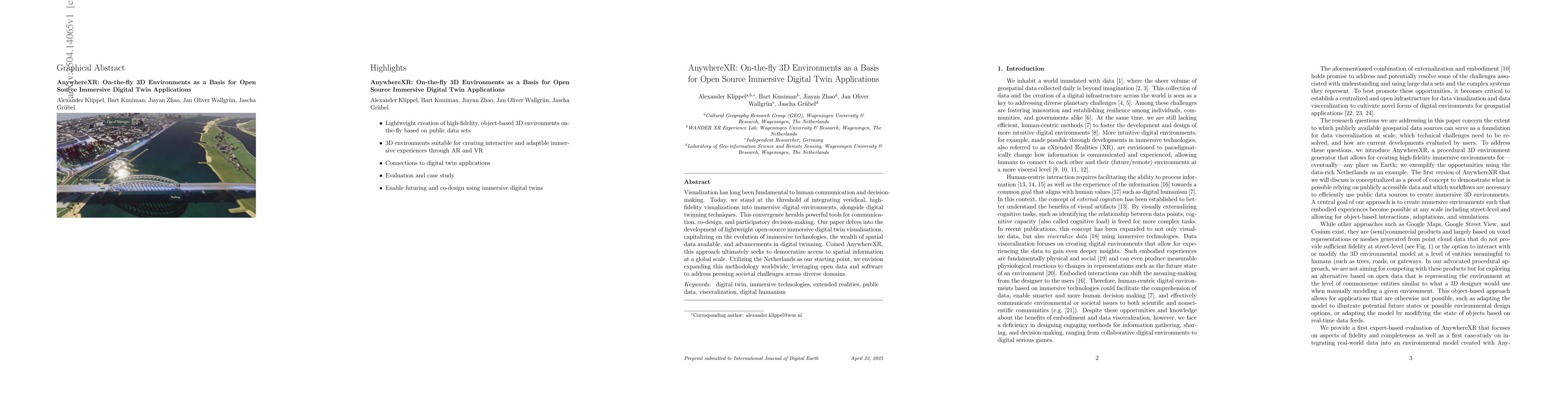
Visualization has long been fundamental to human communication and decision-making. Today, we stand at the threshold of integrating veridical, high-fidelity visualizations into immersive digital environments, alongside digital twinning techniques. This convergence heralds powerful tools for communication, co-design, and participatory decision-making. Our paper delves into the development of lightweight open-source immersive digital twin visualisations, capitalizing on the evolution of immersive technologies, the wealth of spatial data available, and advancements in digital twinning. Coined AnywhereXR, this approach ultimately seeks to democratize access to spatial information at a global scale. Utilizing the Netherlands as our starting point, we envision expanding this methodology worldwide, leveraging open data and software to address pressing societal challenges across diverse domains.
Key Findings, in focus
Seven facets of this paper, analysed and brought into focus by AI.
This research contributes to democratizing access to spatial information globally by developing lightweight open-source immersive digital twin visualizations, which can aid in communication, co-design, and participatory decision-making across diverse domains.
- Average visual fidelity scores for buildings, trees, terrain, and roads ranged from 3.1 for trees to 3.8 for terrain (out of 7).
- Highest scores were obtained for a market square seen from above, while the lowest scores came from a very iconic location in Rotterdam, the Cube Houses, shown at street-level.
- Usefulness of virtual environments for games, spatial planning, stakeholder engagement, and environmental data visualization was ranked 67, 51, 51, and 48, respectively.
- Single missing trees significantly deteriorate ratings, while multiple missing objects, unusual buildings, and street-level perspectives also negatively impact perception.
This research contributes to democratizing access to spatial information globally by developing lightweight open-source immersive digital twin visualizations, which can aid in communication, co-design, and participatory decision-making across diverse domains.
AnywhereXR, an open-source platform, automates the creation of 3D environments for immersive digital twins using public and semi-public data, focusing on high visual fidelity and scalability.
AnywhereXR stands out by advancing open research data and infrastructure, integrating diverse datasets, and dynamically scaling terrain complexity based on viewpoint, offering a more realistic and detailed immersive experience compared to traditional 3D tile approaches.
- The evaluation is based on a convenience sample, which may limit the generalizability of the findings.
- The study relies on publicly available data, which might not always provide high visual fidelity, especially in urban areas with fewer trees.
- Mismatches between physical reality and data derived from databases can affect the results.
- Expand the methodology to include more diverse datasets, such as non-authoritative sources and citizen science projects.
- Improve the resolution of small local objects and incorporate AI-based spatial interpolation techniques to fill in missing details in data-sparse areas.
- Explore the integration of AI for immersive experiences, such as language-driven immersive twins and seamless interaction with digital twins.
Paper Details
Authors
PDF Preview
Related Papers
No references found for this paper.
Discussion 0