Are We Ready for Radar to Replace Lidar in All-Weather Mapping and Localization?
Publication
Metrics
AI Quick Summary
This study compares radar-only, lidar-only, and radar-to-lidar systems for all-weather mapping and localization, finding that lidar outperforms radar even in snowstorms. Radar-only systems showed competitive accuracy with a smaller map, indicating potential for improvement in extreme weather scenarios.
Paper Preview
Abstract
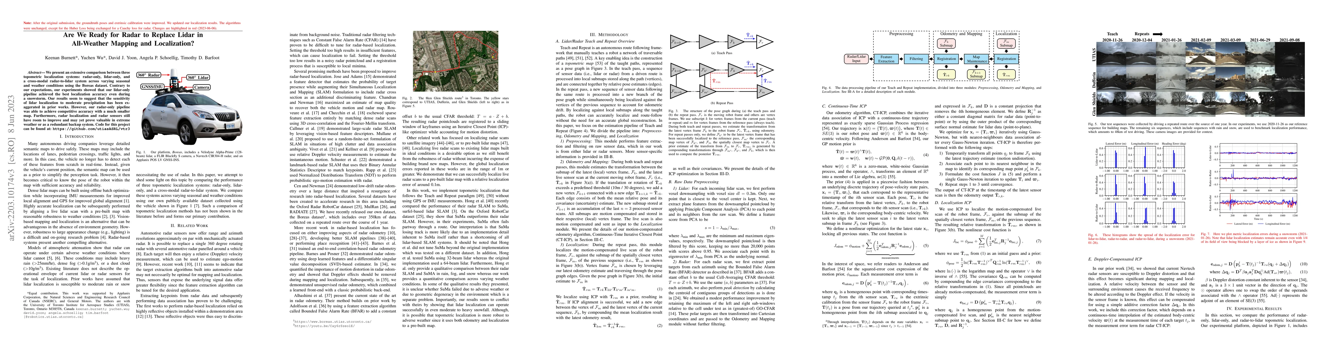
We present an extensive comparison between three topometric localization systems: radar-only, lidar-only, and a cross-modal radar-to-lidar system across varying seasonal and weather conditions using the Boreas dataset. Contrary to our expectations, our experiments showed that our lidar-only pipeline achieved the best localization accuracy even during a snowstorm. Our results seem to suggest that the sensitivity of lidar localization to moderate precipitation has been exaggerated in prior works. However, our radar-only pipeline was able to achieve competitive accuracy with a much smaller map. Furthermore, radar localization and radar sensors still have room to improve and may yet prove valuable in extreme weather or as a redundant backup system. Code for this project can be found at: https://github.com/utiasASRL/vtr3
AI Key Findings
Get AI-generated insights about this paper's methodology, results, significance, and more — seven facets brought into focus.
Impact
Paper Details
Authors
PDF Preview
Key Terms
Citation Network
Current paper (gray), citations (green), references (blue)
Display is limited for performance on very large graphs.
Discussion 0