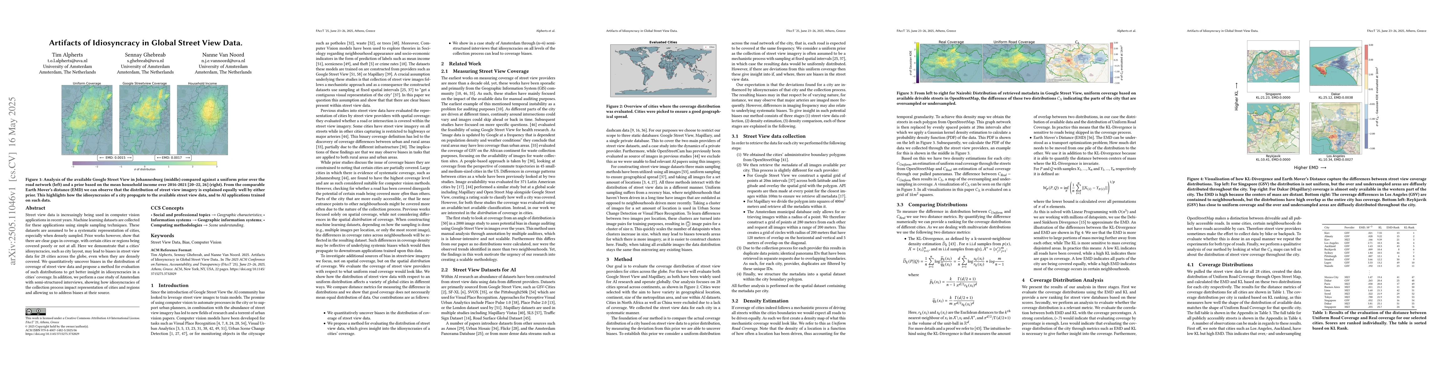
Nexar Dashcam Collision Prediction Dataset and Challenge
|
Daniel C. Moura, Shizhan Zhu, Orly Zvitia
|
2025
|
View Paper
|
Paved or unpaved? A Deep Learning derived Road Surface Global Dataset from Mapillary Street-View Imagery
|
Sukanya Randhawa, Eren Aygun, Guntaj Randhawa, B. Herfort, Sven Lautenbach, Alexander Zipf
|
2024
|
View Paper
|
Segregation and socio-economic sorting in Gauteng
|
C. Hamann
|
2024
|
View Paper
|
Perceptive Visual Urban Analytics is Not (Yet) Suitable for Municipalities
|
Tim Alpherts, S. Ghebreab, Yen-Chia Hsu, Nanne Van Noord
|
2024
|
View Paper
|
CityPulse: Fine-Grained Assessment of Urban Change with Street View Time Series
|
Tianyuan Huang, Zejia Wu, Jiajun Wu, Jackelyn Hwang, Ram Rajagopal
|
2024
|
View Paper
|
An examination of the spatial coverage and temporal variability of Google Street View (GSV) images in small- and medium-sized cities: A people-based approach
|
Junghwan Kim, Kee Moon Jang
|
2023
|
View Paper
|
Detecting disparities in police deployments using dashcam data
|
Matt W Franchi, J.D. Zamfirescu-Pereira, Wendy Ju, E. Pierson
|
2023
|
View Paper
|
Computer Vision for Road Imaging and Pothole Detection: A State-of-the-Art Review of Systems and Algorithms
|
Nachuan Ma, Jiahe Fan, Wenshuo Wang, Jin Wu, Yu Jiang, Lihua Xie, Rui Fan
|
2022
|
View Paper
|
Google street view image availability in the Bronx and San Diego, 2007-2020: Understanding potential biases in virtual audits of urban built environments.
|
Cara M. Smith, J. Kaufman, S. Mooney
|
2021
|
View Paper
|
Adaptive-Attentive Geolocalization From Few Queries: A Hybrid Approach
|
G. Berton, Valerio Paolicelli, Carlo Masone, Barbara Caputo
|
2020
|
View Paper
|
Urban Object Detection Kit: A System for Collection and Analysis of Street-Level Imagery
|
M. Sukel, Stevan Rudinac, M. Worring
|
2020
|
View Paper
|
Highly Robust Visual Place Recognition Through Spatial Matching of CNN Features
|
Luis G. Camara, Carl Gäbert, L. Preucil
|
2020
|
View Paper
|
Urban Mosaic: Visual Exploration of Streetscapes Using Large-Scale Image Data
|
Fábio Miranda, Maryam Hosseini, Marcos Lage, Harish Doraiswamy, G. Dove, Cláudio T. Silva
|
2020
|
View Paper
|
Assessing Google Street View Image Availability in Latin American Cities
|
D. Fry, S. Mooney, D. Rodriguez, W. Caiaffa, G. Lovasi
|
2020
|
View Paper
|
The Mapillary Traffic Sign Dataset for Detection and Classification on a Global Scale
|
C. Ertler, Jerneja Mislej, Tobias Ollmann, L. Porzi, Gerhard Neuhold, Yubin Kuang
|
2019
|
View Paper
|
Every single street? Rethinking full coverage across street‐level imagery platforms
|
Sterling D. Quinn, Luis Álvarez-León
|
2019
|
View Paper
|
Measuring social, environmental and health inequalities using deep learning and street imagery
|
Esra Suel, J. Polak, J. Bennett, M. Ezzati
|
2019
|
View Paper
|
D2-City: A Large-Scale Dashcam Video Dataset of Diverse Traffic Scenarios
|
Zhengping Che, Max Guangyu Li, Tracy Li, Bo Jiang, Xuefeng Shi, Xinsheng Zhang, Ying Lu, Guobin Wu, Yan Liu, Jieping Ye
|
2019
|
View Paper
|
StreetNet: preference learning with convolutional neural network on urban crime perception
|
Kaiqun Fu, Zhiqian Chen, Chang-Tien Lu
|
2018
|
View Paper
|
Interpolating between Optimal Transport and MMD using Sinkhorn Divergences
|
Jean Feydy, Thibault Séjourné, François-Xavier Vialard, S. Amari, A. Trouvé, G. Peyré
|
2018
|
View Paper
|
The Mapillary Vistas Dataset for Semantic Understanding of Street Scenes
|
Gerhard Neuhold, Tobias Ollmann, S. R. Bulò, P. Kontschieder
|
2017
|
View Paper
|
Green streets − Quantifying and mapping urban trees with street-level imagery and computer vision
|
Ian Seiferling, Nikhil Naik, C. Ratti, R. Proulx
|
2017
|
View Paper
|
Interviewing in Social Science Research: A Relational Approach
|
Lee Ann Fujii
|
2017
|
View Paper
|
Using deep learning to quantify the beauty of outdoor places
|
C. Seresinhe, Tobias Preis, H. S. Moat
|
2017
|
View Paper
|
Using deep learning and Google Street View to estimate the demographic makeup of neighborhoods across the United States
|
Timnit Gebru, J. Krause, Yilun Wang, Duyun Chen, Jia Deng, Erez Aiden Lieberman, Li Fei-Fei
|
2017
|
View Paper
|
Deep Learning the City: Quantifying Urban Perception at a Global Scale
|
Abhimanyu Dubey, Nikhil Naik, Devi Parikh, R. Raskar, César A. Hidalgo
|
2016
|
View Paper
|
Street-view change detection with deconvolutional networks
|
P. Alcantarilla, Simon Stent, G. Ros, R. Arroyo, R. Gherardi
|
2016
|
View Paper
|
Training a Convolutional Neural Network for Appearance-Invariant Place Recognition
|
Ruben Gomez-Ojeda, Manuel López-Antequera, N. Petkov, Javier González Jiménez
|
2015
|
View Paper
|
Learning High-Level Judgments of Urban Perception
|
Vicente Ordonez, Tamara L. Berg
|
2014
|
View Paper
|
Streetscore -- Predicting the Perceived Safety of One Million Streetscapes
|
Nikhil Naik, Jade Philipoom, R. Raskar, César A. Hidalgo
|
2014
|
View Paper
|
Using google street view for systematic observation of the built environment: analysis of spatio-temporal instability of imagery dates
|
Jacqueline W Curtis, Andrew Curtis, Jennifer Mapes, Andrea Szell, A. Cinderich
|
2013
|
View Paper
|
Graph-Based Discriminative Learning for Location Recognition
|
Song Cao, Noah Snavely
|
2013
|
View Paper
|
Visual Place Recognition with Repetitive Structures
|
A. Torii, Josef Sivic, M. Okutomi, T. Pajdla
|
2013
|
View Paper
|
The global network of outdoor webcams: properties and applications
|
Nathan Jacobs, W. Burgin, Nick Fridrich, Austin Abrams, Kylia Miskell, B. Braswell, A. Richardson, Robert Pless
|
2009
|
View Paper
|
Kullback-Leibler divergence estimation of continuous distributions
|
F. Pérez-Cruz
|
2008
|
View Paper
|
2024. Analysing and organising human communications for AI fairness assessment: Use cases from the Dutch Public Sector
|
|
2024
|
|
2022. A Deep-Learning Method for the Prediction of Socio-Economic Indicators from Street-View Imagery Using a Case Study from Brazil
|
|
2022
|
|
2022. GSV-Cities: Toward appropriate supervised visual place recognition
|
|
2022
|
|
Inside Out Visual Place Recognition. CoRR abs/2111.13546 (2021
|
|
2021
|
|
MapillaryStreet-LevelSequences:ADatasetforLifelongPlaceRecognition
|
|
2020
|
|
Google Land-marks Dataset v2 - A Large-Scale Benchmark for Instance-Level Recognition Retrieval
|
|
2020
|
|
Se-crecy and Methods in
|
|
2019
|
|
Take a Look around: Using Street View and Satellite Images to Estimate House Prices
|
|
2019
|
|
Weakly Supervised Silhouette-based Semantic Change Detection
|
Ken Sakurada
|
2018
|
View Paper
|
SystematicReviewoftheUseofGoogleStreetView in Health Research: Major Themes, Strengths, Weaknesses and Possibilities for FutureResearch
|
|
2018
|
|
NetVLAD:CNNArchitectureforWeaklySupervisedPlaceRecognition
|
|
2018
|
|
OpenStreetMap contributors
|
|
2017
|
|
GautengCity-RegionObservatory(GCRO)
|
|
2016
|
|
CityForensics:UsingVisualElementstoPredictNon-VisualCityAttributes
|
|
2014
|
|
Markov Processes over Denumerable Products of Spaces, Describing Large Systems of Automata
|
|
1969
|
|
2022. City-Wide Perceptions of Neighbourhood Quality Using Street View Images
|
|
|
|
FAccT ’25, June 23–26, 2025
|
|
|
|
2022. Quality of Life Survey V 2017-2018
|
|
|
|
Artifacts of Idiosyncracy
|
|
|
|
Torii-CVPR-2015-final
|
|
|
|
2022. Rethinking Visual Geo-localization for Large-Scale Applications
|
|
|
|
Due to the collection process for each provider this results in duplicate data points; identical panorama IDs that
|
|
|
|
2023. On the Potential of Google Street View for Environmental WasteQuantificationinUrbanAfrica: AnAssessmentofBiasinSpatialCoverage
|
|
|
|
2022. PanorAMS:Automatic Annotation for Detecting Objects in Urban Context. (2022)
|
|
|
|
Comments (0)