Attention-Based Ensemble Learning for Crop Classification Using Landsat 8-9 Fusion
Publication
Metrics
AI Quick Summary
This study effectively utilizes Landsat 8-9 imagery fusion and advanced modeling techniques, including attention-based ensemble learning, to classify six target crops in Central Punjab's irrigated regions. The methodology involves field surveys, rigorous image pre-processing, vegetation index extraction, and classification modeling, resulting in a comprehensive dataset of 50,835 data points with improved crop classification accuracy.
Paper Preview
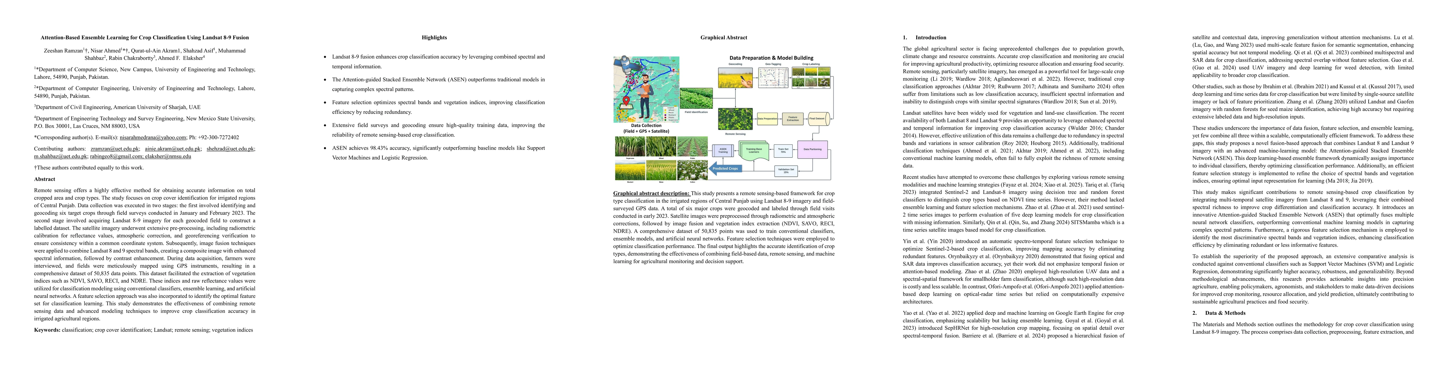
Abstract
Remote sensing offers a highly effective method for obtaining accurate information on total cropped area and crop types. The study focuses on crop cover identification for irrigated regions of Central Punjab. Data collection was executed in two stages: the first involved identifying and geocoding six target crops through field surveys conducted in January and February 2023. The second stage involved acquiring Landsat 8-9 imagery for each geocoded field to construct a labelled dataset. The satellite imagery underwent extensive pre-processing, including radiometric calibration for reflectance values, atmospheric correction, and georeferencing verification to ensure consistency within a common coordinate system. Subsequently, image fusion techniques were applied to combine Landsat 8 and 9 spectral bands, creating a composite image with enhanced spectral information, followed by contrast enhancement. During data acquisition, farmers were interviewed, and fields were meticulously mapped using GPS instruments, resulting in a comprehensive dataset of 50,835 data points. This dataset facilitated the extraction of vegetation indices such as NDVI, SAVO, RECI, and NDRE. These indices and raw reflectance values were utilized for classification modeling using conventional classifiers, ensemble learning, and artificial neural networks. A feature selection approach was also incorporated to identify the optimal feature set for classification learning. This study demonstrates the effectiveness of combining remote sensing data and advanced modeling techniques to improve crop classification accuracy in irrigated agricultural regions.
AI Key Findings
Get AI-generated insights about this paper's methodology, results, significance, and more — seven facets brought into focus.
Impact
Paper Details
Authors
PDF Preview
Citation Network
Current paper (gray), citations (green), references (blue)
Display is limited for performance on very large graphs.
Discussion 0