Augmented Semantic Signatures of Airborne LiDAR Point Clouds for Comparison
Publication
Metrics
AI Quick Summary
This paper proposes an orientation-invariant geometric signature for comparing airborne LiDAR point clouds, integrating probabilistic geometric and semantic classifications to capture differences without registration. The study finds that differences in these signatures correlate well with actual geometric and semantic variations in the point clouds.
Paper Preview
Abstract
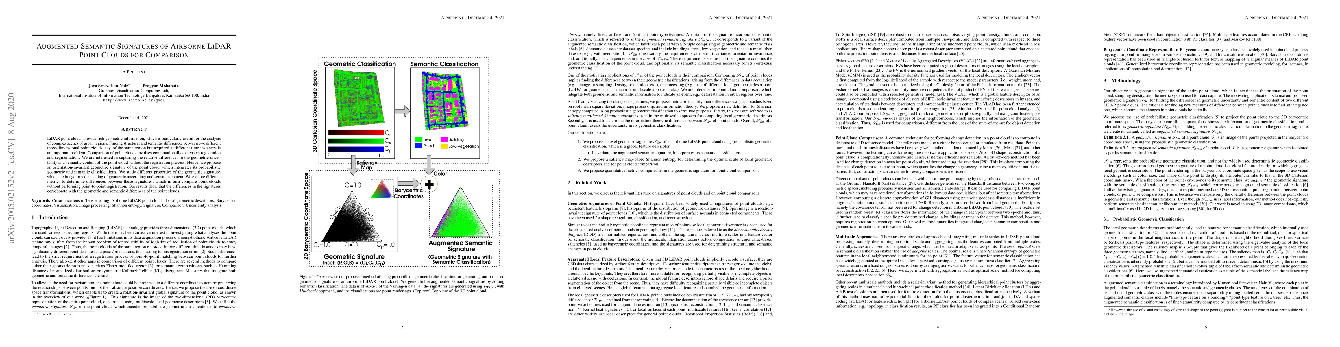
LiDAR point clouds provide rich geometric information, which is particularly useful for the analysis of complex scenes of urban regions. Finding structural and semantic differences between two different three-dimensional point clouds, say, of the same region but acquired at different time instances is an important problem. A comparison of point clouds involves computationally expensive registration and segmentation. We are interested in capturing the relative differences in the geometric uncertainty and semantic content of the point cloud without the registration process. Hence, we propose an orientation-invariant geometric signature of the point cloud, which integrates its probabilistic geometric and semantic classifications. We study different properties of the geometric signature, which are an image-based encoding of geometric uncertainty and semantic content. We explore different metrics to determine differences between these signatures, which in turn compare point clouds without performing point-to-point registration. Our results show that the differences in the signatures corroborate with the geometric and semantic differences of the point clouds.
AI Key Findings
Get AI-generated insights about this paper's methodology, results, significance, and more — seven facets brought into focus.
Impact
Paper Details
PDF Preview
Key Terms
Citation Network
Current paper (gray), citations (green), references (blue)
Display is limited for performance on very large graphs.
Discussion 0