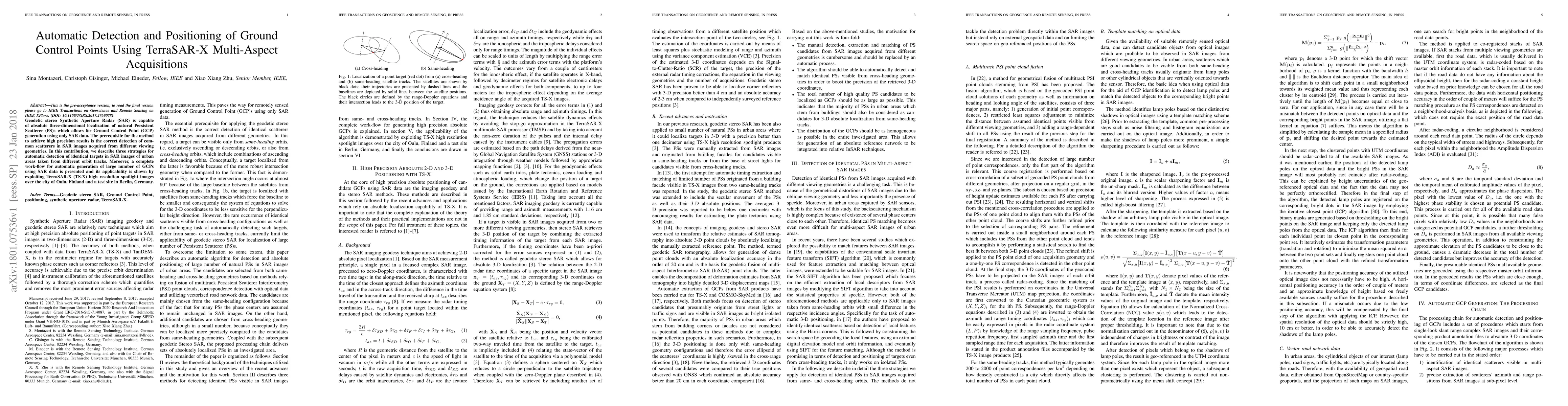
This paper presents three strategies for automatically detecting identical targets in TerraSAR-X SAR images from different viewing angles to generate Ground Control Points (GCPs). The workflow is demonstrated using high-resolution spotlight images from Oulu, Finland, and Berlin, Germany, showcasing the method's precision and applicability.
Geodetic stereo Synthetic Aperture Radar (SAR) is capable of absolute three-dimensional localization of natural Persistent Scatterer (PS)s which allows for Ground Control Point (GCP) generation using only SAR data. The prerequisite for the method to achieve high precision results is the correct detection of common scatterers in SAR images acquired from different viewing geometries. In this contribution, we describe three strategies for automatic detection of identical targets in SAR images of urban areas taken from different orbit tracks. Moreover, a complete work-flow for automatic generation of large number of GCPs using SAR data is presented and its applicability is shown by exploiting TerraSAR-X (TS-X) high resolution spotlight images over the city of Oulu, Finland and a test site in Berlin, Germany.
This graph shows how this paper is connected to other research. The current paper is shown in dark gray, papers that cite it are in green, and papers it references are in blue. You can:
• Hover over any node to see the paper title
• Click a node to view that paper's details
• Drag nodes to rearrange the graph
• Use the zoom controls (bottom right) to zoom in/out
Title | Authors | Year | Actions |
---|---|---|---|
Volume Estimation of Land Surface Change Based on GaoFen-7
|
Chen Yin, Qingke Wen, Shuo Liu, Yixin Yuan, Dong Yang, Xiankun Shi
|
2025
|
View Paper |
A sensitive geometric self-calibration method and stability analysis for multiview spaceborne SAR images based on the range-Doppler model
|
Lina Yin, Mingjun Deng, Yin Yang, Yunqing Huang, Qili Tang
|
2025
|
View Paper |
Generation of Virtual Ground Control Points Using a Binocular Camera
|
Ariel Vazquez-Dominguez, A. Magadán-Salazar, R. Pinto-Elías, J. Fuentes-Pacheco, Máximo López-Sánchez, Hernán Abaunza-González
|
2024
|
View Paper |
ASSESSING THE ACCURACY OF GEOREFERENCED POINT CLOUDS FROM UAS IMAGERY
|
E. Clay, K. Lee, S. Tan, L. N. H. Truong, O. Mora, W. Cheng
|
2022
|
View Paper |
System Concepts and Potential Applications of a Tri-Beam Spaceborne SAR Mission
|
Fengming Hu, Fengli Xue, F. Xu
|
2021
|
View Paper |
A Novel Method for Fast Positioning of Non-Standardized Ground Control Points in Drone Images
|
Zheng Zhu, Tengfei Bao, Yuhan Hu, Jian Gong
|
2021
|
View Paper |
Derivation of high-quality three-dimensional surface deformation velocities through multi-source point cloud fusion: Application to Kīlauea volcano
|
Wenqing Wu, Jun Hu, Jihui Liu, Zhi‐wei Li, Jianjun Zhu, Bing Xu, Wanji Zheng, Xingqing Zhang
|
2021
|
View Paper |
Paradigm Changes in Surface-Motion Estimation From SAR: Lessons From 16 Years of Sino-European Cooperation in the Dragon Program
|
M. Liao, T. Balz, F. Rocca, Deren Li
|
2020
|
View Paper |
Matching of TerraSAR-X derived ground control points to optical image patches using deep learning
|
Tatjana Bürgmann, W. Koppe, M. Schmitt
|
2019
|
View Paper |
Detection and 3D Visualization of Deformations for High-Rise Buildings in Shenzhen, China from High-Resolution TerraSAR-X Datasets
|
Wu, Cui, Hu, Yao
|
2019
|
View Paper |
Geodetic Synthetic Aperture Radar Interferometry
|
S. Montazeri
|
2019
|
View Paper |
Mitigation of Positioning Bias in PSI Point Clouds
|
S. Montazeri, Fernando Rodríguez González, Xiaoxiang Zhu
|
2019
|
View Paper |
Geocoding Error Correction for InSAR Point Clouds
|
S. Montazeri, Fernando Rodríguez González, Xiaoxiang Zhu
|
2018
|
View Paper |
A Review of Ten-Year Advances of Multi-Baseline SAR Interferometry Using TerraSAR-X Data
|
Xiaoxiang Zhu, Yuanyuan Wang, S. Montazeri, N. Ge
|
2018
|
View Paper |
The Generalized Gamma-DBN for High-Resolution SAR Image Classification
|
Zhiqiang Zhao, Lei Guo, M. Jia, Lei Wang
|
2018
|
View Paper |
Extraction, Positioning, and Quality Control of Lamp-Pole GCP From Spaceborne Stereo SAR Images
|
Hao Zhang, Yuanhao Li
|
2025
|
View Paper |
利用光学阴影特征进行点位预测的星载合成孔径雷达影像灯杆提取方法
|
李佳豪 Li Jiahao, 靳国旺 Jin Guowang, 熊鑫 Xiong Xin, 叶昊 Ye Hao, 王家骏 Wang Jiajun, 杨鹤 Yang He
|
2024
|
View Paper |
Geometric Auto-Calibration of SAR Images Utilizing Constraints of Symmetric Geometry
|
Kai Xu, Siyuan Liu, Ziyi Wang, Guo Zhang, Yingying Li, Bocai Wu
|
2022
|
View Paper |
Automatic Positioning and Recognition of Anesthesia Points Based on Ultrasound Image Guidance Technology
|
Huanqiu Liu, Fu-zhe Ma, Ji Li, Tingting Yu, Xinbai Li
|
2020
|
View Paper |
Detection and 3D Visualization of Deformations for High-Rise Buildings in Shenzhen, China from High-Resolution TerraSAR-X Datasets
|
Wenqing Wu, H. Cui, Jun Hu, Lina Yao
|
2019
|
View Paper |
TECHNICAL UNIVERSITY OF MUNICH TUM Data Innovation Lab 3D Matching of TerraSAR-X Derived Ground Control Points to Mobile Mapping Data
|
Louise Loesch, I. Mansour, Magdalena Reich, Xianbin Xie, Dr. Wolfgang Koppe, Tatjana Bürgmann, Laure Vuaille, Dr. Ricardo Acevedo Cabra, Dr. Massimo Fornasier
|
2019
|
View Paper |
Xumin Gao
Published: 2024-12-12
Published: 2012-11-15
Published: 2017-09-25
Zheng Zhi, Wang Chao, Li Xiaopeng, Cheng Chuanxiang, Yang Jia, Dong Di, Chang Mengxia, Zhuang Zhiheng
Published: 2023-03-07
Comments (0)