Publication
Metrics
AI Quick Summary
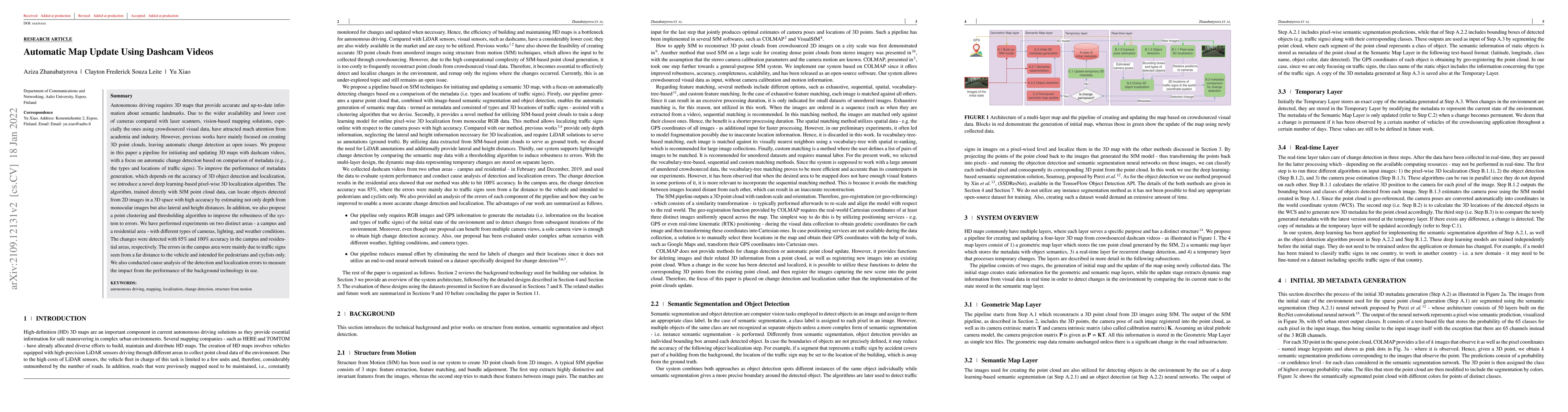
This paper proposes a pipeline for updating 3D maps using dashcam videos, focusing on automatic change detection via metadata comparison. It introduces a deep learning-based algorithm for pixel-wise 3D localization to enhance the accuracy of 3D object detection and localization, achieving 85% and 100% change detection accuracy in campus and residential areas, respectively.
Paper Preview
Abstract
Autonomous driving requires 3D maps that provide accurate and up-to-date information about semantic landmarks. Due to the wider availability and lower cost of cameras compared with laser scanners, vision-based mapping solutions, especially the ones using crowdsourced visual data, have attracted much attention from academia and industry. However, previous works have mainly focused on creating 3D point clouds, leaving automatic change detection as open issues. We propose in this paper a pipeline for initiating and updating 3D maps with dashcam videos, with a focus on automatic change detection based on comparison of metadata (e.g., the types and locations of traffic signs). To improve the performance of metadata generation, which depends on the accuracy of 3D object detection and localization, we introduce a novel deep learning-based pixel-wise 3D localization algorithm. The algorithm, trained directly with SfM point cloud data, can locate objects detected from 2D images in a 3D space with high accuracy by estimating not only depth from monocular images but also lateral and height distances. In addition, we also propose a point clustering and thresholding algorithm to improve the robustness of the system to errors. We have performed experiments on two distinct areas - a campus and a residential area - with different types of cameras, lighting, and weather conditions. The changes were detected with 85% and 100% accuracy in the campus and residential areas, respectively. The errors in the campus area were mainly due to traffic signs seen from a far distance to the vehicle and intended for pedestrians and cyclists only. We also conducted cause analysis of the detection and localization errors to measure the impact from the performance of the background technology in use.
AI Key Findings
Get AI-generated insights about this paper's methodology, results, significance, and more — seven facets brought into focus.
Impact
Paper Details
Authors
PDF Preview
Key Terms
Citation Network
Current paper (gray), citations (green), references (blue)
Display is limited for performance on very large graphs.
Discussion 0