Background
Geographic processes frequently rely on sample data drawn from large inventories of geographic objects. When the sample is not representative, analyses and subsequent knowledge revision can be biased or incomplete. Traditional sampling strategies—random sampling or expert-driven selection—each have drawbacks: randomness can miss rare yet important object types, while expert selection is subjective and difficult to scale to large object sets.
Problem / Research Question
The paper asks how to automatically and robustly select a representative subset of geographic objects that preserves diversity across object types and scales proportionally with their prevalence. The central challenge is to design a sampling method that (i) captures different kinds of objects, including rare groups, (ii) remains computationally feasible for large corpora, and (iii) integrates smoothly with downstream processes such as knowledge revision for geographical generalisation.
Innovation / Contribution
The authors propose a three-step sampling method that combines (i) characterisation of objects via a measure set, (ii) clustering of characterized objects with an EM-based approach, and (iii) selection of representative objects within each cluster. The key idea is to allocate sample size across clusters proportionally to their size in the population, then pick, in each cluster, the objects with the highest probability of belonging to that cluster. This yields a sample that is both diverse (coverage across clusters) and balanced (inclusion of small groups).
Methodology / Approach
Step 1: Object characterisation. For each geographic object, a measure set is computed to describe its properties. In the case study, 11 measures were defined to characterise building groups, forming a rich feature representation.
Step 2: Objects clustering. The characterised set is partitioned into clusters representing similar object types. The EM algorithm is used to estimate cluster memberships, providing soft assignments (probabilities) of objects to clusters.
Step 3: Object selection. The sample size per cluster i (ni) is determined from the desired total sample size and the cluster’s relative size in the population, ensuring proportional representation and inclusion of small groups. Within each cluster, the objects with the highest posterior probability of belonging to that cluster are chosen as representatives.
Experiments / Evaluation
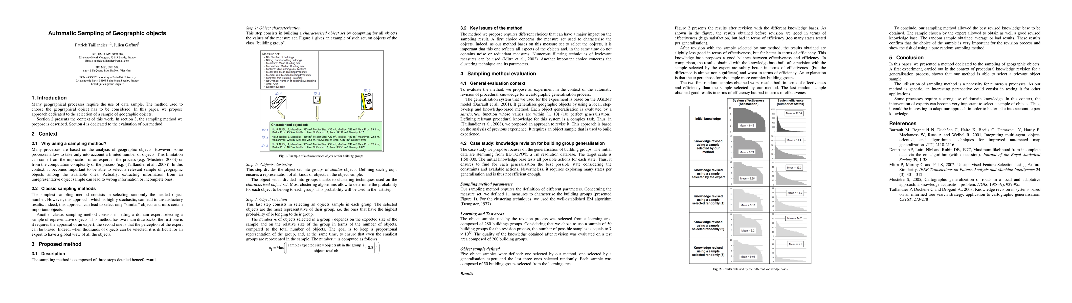
The evaluation is anchored in a case study of knowledge revision for building-group generalisation within a cartographic generalisation framework based on the AGENT model. The initial dataset is BD TOPOfi at 1 meter resolution, with a target scale of 1:50,000. The learning area comprises 280 building groups, from which a sample of 50 groups is drawn for revision. Five object samples are defined for comparison: one produced by the proposed method, one by a generalisation expert, and three random samples. Each sample contains 50 building groups.
The main evaluation criterion is the quality of the revised knowledge base, typically balanced between effectiveness (how well generalisation goals are met) and efficiency (how many states or actions must be explored). Results indicate that the method-produced sample yields a revised knowledge base with notably better efficiency and comparable effectiveness relative to random samples. The expert-selected sample achieves slightly better effectiveness but with similar or worse efficiency, suggesting that the proposed method can rival expert judgment while offering consistent, scalable performance advantages over random sampling.
Key Results
Across the experiments, the sampling method provided the best balance between efficiency and effectiveness in the revision process. Random samples tended to underperform on both dimensions, while the expert sample performed well but did not outperform the proposed method in a statistically significant way on effectiveness and lagged slightly on efficiency. The results underscore that thoughtful, diversity-preserving sampling can meaningfully improve downstream learning and generalisation tasks in geographic information processing.
Practical Applications
The method is presented as generic and applicable beyond the specific case of building-group generalisation. Potential applications include any geospatial analysis or knowledge-revision task that involves large object inventories and limited processing budgets, such as map generalisation, spatial data quality assurance, feature extraction in remote sensing, and scenario testing for geographic decision-support systems.
Limitations & Considerations
The approach relies on the quality and relevance of the chosen measure set to characterize objects. If the measures omit important object aspects or include noisy/redundant features, clustering quality—and hence sample representativeness—may degrade. Choices of clustering parameters (e.g., the number of clusters) and the EM algorithm’s initialization can influence results. The evaluation is conducted within a single domain (building-group generalisation) and a specific data source; generalization to other object types or data resolutions requires empirical validation. Details such as the exact formula used to compute ni and the sensitivity of results to sample size are not exhaustively explored in the excerpt.
Discussion 0