Publication
Metrics
Quick Actions
Quick Answers
What methodology did the authors use?
This research employs an advanced AI-driven perception system for autonomous quadcopter navigation in GPS-denied indoor environments, utilizing cloud computing for offloading computationally intensive tasks and a custom-designed PCB for efficient sensor data acquisition. More in Methodology →
What are the key results?
Object detection achieved a mean Average Precision (mAP50) of 0.6. — Monocular depth estimation had a Mean Absolute Error (MAE) of 7.2 cm. More in Key Results →
Why is this work significant?
This cloud-supported, high-intelligence framework serves as an auxiliary perception and navigation system, complementing state-of-the-art drone autonomy for GPS-denied confined spaces, enhancing safety and efficiency in indoor drone navigation. More in Significance →
What are the main limitations?
Reliance on cloud computing may introduce latency issues in certain scenarios. — Performance may be affected by the quality and reliability of the cloud connection. More in Limitations →
Abstract
This paper introduces an advanced AI-driven perception system for autonomous quadcopter navigation in GPS-denied indoor environments. The proposed framework leverages cloud computing to offload computationally intensive tasks and incorporates a custom-designed printed circuit board (PCB) for efficient sensor data acquisition, enabling robust navigation in confined spaces. The system integrates YOLOv11 for object detection, Depth Anything V2 for monocular depth estimation, a PCB equipped with Time-of-Flight (ToF) sensors and an Inertial Measurement Unit (IMU), and a cloud-based Large Language Model (LLM) for context-aware decision-making. A virtual safety envelope, enforced by calibrated sensor offsets, ensures collision avoidance, while a multithreaded architecture achieves low-latency processing. Enhanced spatial awareness is facilitated by 3D bounding box estimation with Kalman filtering. Experimental results in an indoor testbed demonstrate strong performance, with object detection achieving a mean Average Precision (mAP50) of 0.6, depth estimation Mean Absolute Error (MAE) of 7.2 cm, only 16 safety envelope breaches across 42 trials over approximately 11 minutes, and end-to-end system latency below 1 second. This cloud-supported, high-intelligence framework serves as an auxiliary perception and navigation system, complementing state-of-the-art drone autonomy for GPS-denied confined spaces.
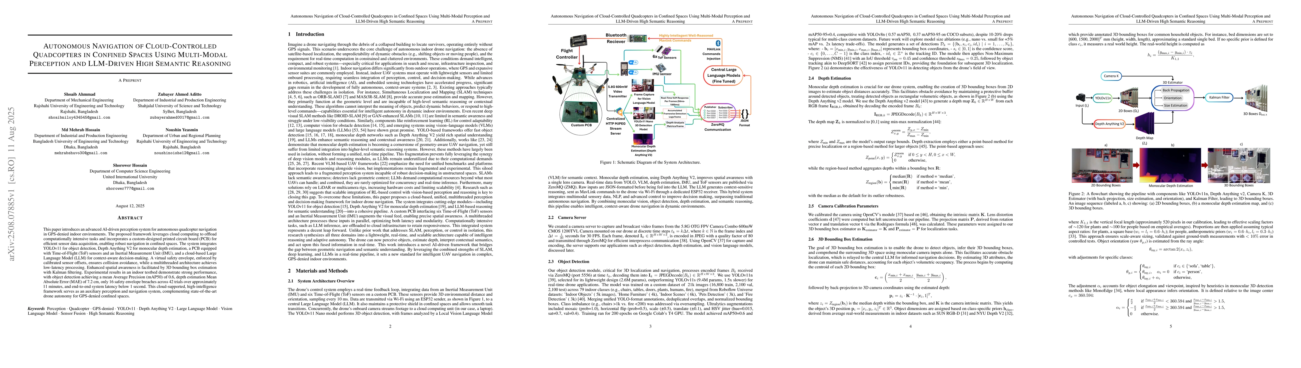
AI Key Findings
Generated Aug 12, 2025
Methodology — What approach did the authors take?
This research employs an advanced AI-driven perception system for autonomous quadcopter navigation in GPS-denied indoor environments, utilizing cloud computing for offloading computationally intensive tasks and a custom-designed PCB for efficient sensor data acquisition.
Key Results — What are the main findings?
- Object detection achieved a mean Average Precision (mAP50) of 0.6.
- Monocular depth estimation had a Mean Absolute Error (MAE) of 7.2 cm.
- The system demonstrated only 16 safety envelope breaches across 42 trials over approximately 11 minutes.
- End-to-end system latency was below 1 second.
- Fine-tuned SmolLM2-360M model achieved 68% navigation command accuracy with 438 ms response time.
Significance — Why does this research matter?
This cloud-supported, high-intelligence framework serves as an auxiliary perception and navigation system, complementing state-of-the-art drone autonomy for GPS-denied confined spaces, enhancing safety and efficiency in indoor drone navigation.
Technical Contribution — What is the technical contribution?
The paper introduces a novel framework that combines YOLOv11 for object detection, Depth Anything V2 for monocular depth estimation, a custom PCB with ToF sensors and IMU, and a cloud-based LLM for context-aware decision-making.
Novelty — What is new about this work?
This work stands out by merging advanced AI components like YOLOv11, Depth Anything V2, and a fine-tuned LLM into a single, lightweight, and scalable framework for real-time perception and decision-making in GPS-denied indoor environments.
Limitations — What are the limitations of this study?
- Reliance on cloud computing may introduce latency issues in certain scenarios.
- Performance may be affected by the quality and reliability of the cloud connection.
Future Work — What did the authors propose for future work?
- Explore integration of LiDAR for improved obstacle avoidance on inclined surfaces.
- Investigate domain-specific LLM fine-tuning for enhanced contextual reasoning.
Paper Details
How to Cite This Paper
@article{hossain2025autonomous,
title = {Autonomous Navigation of Cloud-Controlled Quadcopters in Confined Spaces
Using Multi-Modal Perception and LLM-Driven High Semantic Reasoning},
author = {Hossain, Md Mehrab and Yeasmin, Noushin and Ahmmad, Shoaib and others},
year = {2025},
eprint = {2508.07885},
archivePrefix = {arXiv},
primaryClass = {cs.RO},
}
Hossain, M., Yeasmin, N., Ahmmad, S., Hossain, S., & Aditto, Z. (2025). Autonomous Navigation of Cloud-Controlled Quadcopters in Confined Spaces
Using Multi-Modal Perception and LLM-Driven High Semantic Reasoning. arXiv. https://arxiv.org/abs/2508.07885
Hossain, Md Mehrab, et al. "Autonomous Navigation of Cloud-Controlled Quadcopters in Confined Spaces
Using Multi-Modal Perception and LLM-Driven High Semantic Reasoning." arXiv, 2025, arxiv.org/abs/2508.07885.
PDF Preview
Similar Papers
Found 4 papersSensor Fusion for Autonomous Indoor UAV Navigation in Confined Spaces
Alice James, Avishkar Seth, Endrowednes Kuantama et al.
Autonomous UAV Flight Navigation in Confined Spaces: A Reinforcement Learning Approach
Marco S. Tayar, Lucas K. de Oliveira, Juliano D. Negri et al.
Object Navigation with Structure-Semantic Reasoning-Based Multi-level Map and Multimodal Decision-Making LLM
Chongshang Yan, Jiaxuan He, Delun Li et al.
Comments (0)