Background
Mobile robots relying on sonar must contend with wide beams that inflate uncertainty in obstacle localization, alongside measurement noise and dropout phenomena caused by surface properties and specular reflections. Prior work, notably Elfes and grid‑based schemes, treated each grid cell as an independent object with occupancy probabilities updated by sensor readings. While this independence simplifies computation, it inadequately captures the interdependencies among spatial regions implied by a single reading and by multiple readings from different viewpoints. The paper argues that true spatial inference should account for the fact that a single obstacle, if present, can influence a set of nearby regions, and that readings are not independent indicators of occupancy when dropouts occur.
Problem / Research Question
The central problem is to develop a probabilistic model for sonar fusion that preserves useful spatial dependencies among regions while handling dropout and false readings, without imposing unrealistic independence across space. The key research question asks whether a Bayes net that couples readings to dynamically defined spatial regions can outperform independence‑based grid models in discounting bogus readings and reinforcing genuine obstacles, especially under high dropout conditions.
Innovation / Contribution
The paper’s main contribution is a Bayes network formulation that replaces per‑cell independence with region‑level dependencies, defined by regions that are quasi‑invariant to the reading set. The network is constructed dynamically: for each new reading, new region nodes and corresponding reading nodes are created, and the readings are linked to the regions they could affect. To manage in‑degree and inference, each reading node is expanded into two intermediate or‑nodes (pro and con) which capture whether a reading is a true observation, a dropout, or a spurious signal. This three‑level network (regions -> readings -> pro/con indicators) allows joint probabilistic reasoning about which regions are occupied, given all available evidence.
Methodology / Approach
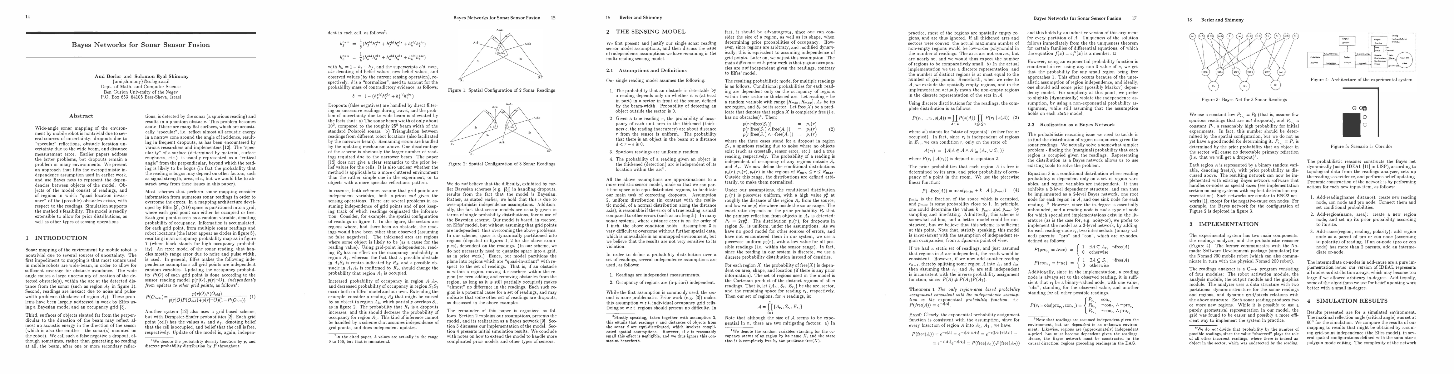
The model rests on a sensor interpretation that treats each reading as originating from a sector and a thicken arc around the measured distance. Regions are defined as the Cartesian product of arc segments, sectors, and the remaining space, with occupancy modeled as binary variables free(A) or occupied. The conditional likelihoods for a reading depend only on the state of the regions within its sector/arc, and readings are treated as conditionally independent given the environment. Priors for region occupancy are area‑dependent, using a piecewise linear function parameterized by Pmin, Pmax, and a shape constant k, to reflect sparse initial occupancy that grows with evidence. The Bayes network is implemented with IDEAL, constructing the network on‑the‑fly via operations Add-reading, Add-region, and Add-cause, and updating beliefs with belief propagation.
Experiments / Evaluation
Experiments are conducted in a simulated environment with a maximal reflection angle (critical angle) set to capture specular dropouts. The study compares the Bayes‑net approach to the grid‑point independence model (Elfesian occupancy) across two geometric scenarios: a corridor turn and an irregular polygon. Key parameters include Pr (true positive probability per reading), dropout probability, Po (base spurious reading probability), and Pmax (maximum occupancy probability). The Bayes network demonstrated an ability to discount dropouts by pooling evidence from multiple overlapping readings, producing occupancy maps that better reflect actual obstacles than the independent‑cell model.
In terms of performance, the paper reports that a Bayes network with around two dozen readings and about a hundred regions could be updated in roughly one CPU‑minute in their IDEAL implementation, but larger networks (e.g., 25 readings and 115 regions) grew to several hours, illustrating the well‑known scalability challenge of exact belief propagation in dense, dynamically constructed graphs. The results include qualitative visual displays (gray‑level occupancy maps) and a comparison showing the Bayes approach preserves nearby obstacles more faithfully under dropout conditions than the independent model.
Key Results
The central finding is that the Bayes network approach can overcome dropout‑driven misclassifications that plague independent grid updates. When detection arcs from several readings intersect a region, their combined evidence raises the posterior occupancy probability, even if individual readings would have suggested free space. Conversely, regions associated with dropouts are less likely to be spuriously deemed occupied once corroborating readings from different viewpoints are considered. The approach thus yields more robust mapping in cluttered environments and under imperfect sensor conditions, at the expense of higher computational complexity that motivates future scalability strategies.
Practical Applications
The methodology is directly applicable to autonomous navigation in indoor and cluttered outdoor spaces where sonar is the primary sensing modality or used in conjunction with other sensors. The Bayes network framework can incorporate prior maps, known walls, or probabilistic priors from other sensing modalities, and can be extended to include temporal dynamics or additional sensors. In practice, this work points to a principled pathway for improving obstacle maps used by planning and control modules in mobile robots, especially in environments where dropouts and specular surfaces are common.
Limitations & Considerations
The major limitation highlighted by the authors is scalability: exact inference becomes computationally prohibitive as the number of readings and regions grows, forcing ad hoc compromises in network size. They propose several directions to mitigate this, including partitioning strategies that trigger region refinement only when posterior probabilities become extreme, magnitude‑based approximations, and sampling approaches. Additional considerations include sensitivity to model assumptions (uniform distance distributions within arcs, fixed dropout/true‑positive probabilities), integration of prior knowledge, and handling of registration and localization errors, which can complicate how regions map to physical space. The authors acknowledge that extending beyond gross sonar uncertainty toward small measurement errors (e.g., through Kalman‑style fusion) or real‑world deployment requires further refinement and testing.
Discussion 0