ArxivLens

Publication

Published: Oct 23, 2025
Categories: cs.LG, eess.SP, 68T05

Metrics

Source: ArXiv

Quick Answers

What methodology did the authors use?

The research proposes a hybrid Bayesian mixture-of-experts framework that combines a physical path-loss model with a convolutional neural network (CNN) using log-linear pooling. Bayesian inference with Laplace approximation is employed to estimate the jammer position and received signal strength (RSS) field. More in Methodology →

What are the key results?

Localization accuracy improves with more training points — Uncertainty decreases as training data increases More in Key Results →

Why is this work significant?

This work addresses the challenge of jammer localization in urban environments by integrating physical models with data-driven approaches, enabling more accurate and reliable RSS field reconstruction and jammer position estimation. More in Significance →

What are the main limitations?

The method relies on building-height maps which may not be available in all scenarios — Performance may degrade in areas with sparse training data More in Limitations →

Paper Preview

Abstract

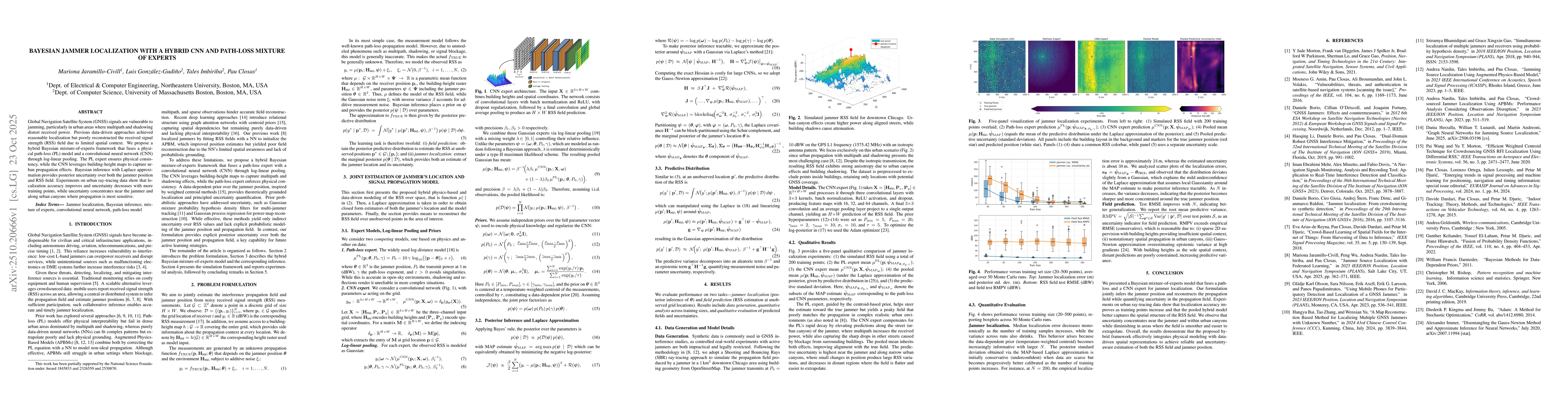
Global Navigation Satellite System (GNSS) signals are vulnerable to jamming, particularly in urban areas where multipath and shadowing distort received power. Previous data-driven approaches achieved reasonable localization but poorly reconstructed the received signal strength (RSS) field due to limited spatial context. We propose a hybrid Bayesian mixture-of-experts framework that fuses a physical path-loss (PL) model and a convolutional neural network (CNN) through log-linear pooling. The PL expert ensures physical consistency, while the CNN leverages building-height maps to capture urban propagation effects. Bayesian inference with Laplace approximation provides posterior uncertainty over both the jammer position and RSS field. Experiments on urban ray-tracing data show that localization accuracy improves and uncertainty decreases with more training points, while uncertainty concentrates near the jammer and along urban canyons where propagation is most sensitive.

Key Findings, in focus

Seven facets of this paper, analysed and brought into focus by AI.

AI-generated · verify against source Generated Oct 24, 2025
In focus · one-line synthesis

This work addresses the challenge of jammer localization in urban environments by integrating physical models with data-driven approaches, enabling more accurate and reliable RSS field reconstruction and jammer position estimation.

01
MethodologyHow they did it

The research proposes a hybrid Bayesian mixture-of-experts framework that combines a physical path-loss model with a convolutional neural network (CNN) using log-linear pooling. Bayesian inference with Laplace approximation is employed to estimate the jammer position and received signal strength (RSS) field.

02
ResultsWhat they found
  • Localization accuracy improves with more training points
  • Uncertainty decreases as training data increases
  • Uncertainty concentrates near the jammer and along urban canyons where propagation is most sensitive
03
SignificanceWhy it matters

This work addresses the challenge of jammer localization in urban environments by integrating physical models with data-driven approaches, enabling more accurate and reliable RSS field reconstruction and jammer position estimation.

04
Technical ContributionsWhat's new technically

A hybrid model that fuses a path-loss expert with a CNN through log-linear pooling, enabling joint estimation of jammer location and signal propagation model parameters.

05
NoveltyWhat sets it apart

The integration of a physics-based path-loss model with a data-driven CNN using log-linear pooling, combined with Bayesian inference for uncertainty quantification, represents a novel approach to jammer localization in complex urban environments.

06
LimitationsWhat to be cautious about
  • The method relies on building-height maps which may not be available in all scenarios
  • Performance may degrade in areas with sparse training data
07
Future WorkWhere it goes next
  • Exploring the use of additional spatial context beyond building-height maps
  • Investigating the application of the framework to other signal propagation scenarios

Paper Details

Paper ID: 2510.20666
Comments: 5 pages, 4 figures, Submitted to ICASSPW 2026
Categories:
cs.LG eess.SP 68T05 68T07 62F15 94A12

How to Cite This Paper

Reference manager: RIS EndNote

Related Papers

4 found


Discussion 0

This website uses cookies to ensure you get the best experience. Learn more