Quick Answers
What methodology did the authors use?
Combined field-derived fungal richness estimates with self-supervised learning on Sentinel-1/2 time series to extract 128-dimensional embeddings, then trained regression models to predict ectomycorrhizal richness across Europe and Asia. More in Methodology →
What are the key results?
SSL embeddings explain >50% of variance in species richness — SSL features outperform climate, soil, and land‑cover predictors More in Key Results →
Why is this work significant?
Provides a scalable, high-resolution, and temporally dynamic tool for monitoring the invisible half of terrestrial ecosystems, informing conservation and policy decisions. More in Significance →
What are the main limitations?
Dependence on satellite data quality and cloud cover — Model trained on limited geographic scope may not generalize globally without further validation More in Limitations →
Abstract
Mycorrhizal fungi are vital to terrestrial ecosystem functioning. Yet monitoring their biodiversity at landscape scales is often unfeasible due to time and cost constraints. Current predictions suggest that 90\% of mycorrhizal diversity hotspots remain unprotected, opening questions of how to broadly and effectively map underground fungal communities. Here, we show that self-supervised learning (SSL) applied to satellite imagery can predict below-ground ectomycorrhizal fungal richness across diverse environments. Our models explain over half the variance in species richness across ~12,000 field samples spanning Europe and Asia. SSL-derived features prove to be the single most informative predictor, subsuming the majority of information contained in climate, soil, and land cover datasets. Using this approach, we achieve a 10,000-fold increase in spatial resolution over existing techniques, moving from 1km landscape averages to 10m habitat-scale observations with nearly no systematic bias. As satellite observations are dynamic rather than static, this enables temporal monitoring of below-ground biodiversity at landscape scales for the first time. We analyze multi-year trends in predicted fungal richness across UK National Park woodlands, finding that ancient forests may be losing ectomycorrhizal diversity at disproportionate rates. These results establish SSL satellite features as a scalable tool for extending sparse field observations to continuous, high-resolution biodiversity maps for monitoring the invisible half of terrestrial ecosystems.
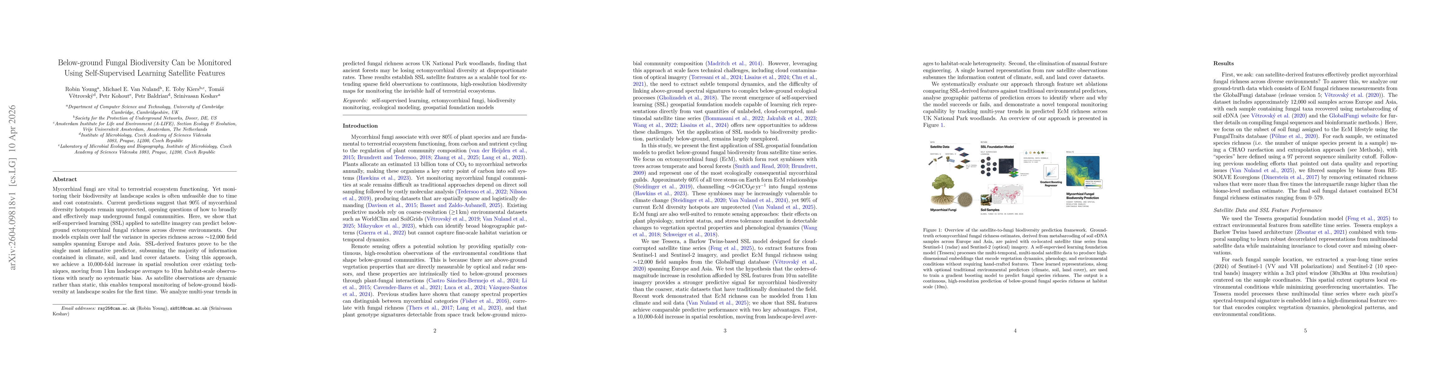
AI Key Findings
Generated Apr 15, 2026
Methodology — What approach did the authors take?
Combined field-derived fungal richness estimates with self-supervised learning on Sentinel-1/2 time series to extract 128-dimensional embeddings, then trained regression models to predict ectomycorrhizal richness across Europe and Asia.
Key Results — What are the main findings?
- SSL embeddings explain >50% of variance in species richness
- SSL features outperform climate, soil, and land‑cover predictors
- Achieved 10,000-fold increase in spatial resolution to 10 m and revealed temporal loss of diversity in ancient UK forests
Significance — Why does this research matter?
Provides a scalable, high-resolution, and temporally dynamic tool for monitoring the invisible half of terrestrial ecosystems, informing conservation and policy decisions.
Technical Contribution — What is the technical contribution?
Development and application of a Barlow Twins-based self-supervised foundation model (Tessera) that learns robust representations from multi-modal, cloud-corrupted satellite time series for ecological prediction.
Novelty — What is new about this work?
First demonstration that self-supervised satellite features can replace traditional climate, soil, and land‑cover predictors to map below-ground fungal biodiversity at 10 m resolution and track temporal changes.
Limitations — What are the limitations of this study?
- Dependence on satellite data quality and cloud cover
- Model trained on limited geographic scope may not generalize globally without further validation
Future Work — What did the authors propose for future work?
- Extend the approach to other continents and ecosystem types
- Incorporate additional environmental layers and improve temporal forecasting of fungal diversity
How to Cite This Paper
@article{kiers2026below,
title = {Below-ground Fungal Biodiversity Can be Monitored Using Self-Supervised Learning Satellite Features},
author = {Kiers, E. Toby and Nuland, Michael E. Van and Baldrian, Petr and others},
year = {2026},
eprint = {2604.09818},
archivePrefix = {arXiv},
primaryClass = {cs.LG},
}
Kiers, E., Nuland, M., Baldrian, P., Kohout, P., Young, R., Keshav, S., & Větrovský, T. (2026). Below-ground Fungal Biodiversity Can be Monitored Using Self-Supervised Learning Satellite Features. arXiv. https://arxiv.org/abs/2604.09818
Kiers, E. Toby, et al. "Below-ground Fungal Biodiversity Can be Monitored Using Self-Supervised Learning Satellite Features." arXiv, 2026, arxiv.org/abs/2604.09818.
PDF Preview
Similar Papers
Found 4 papersDetecting Tidal Features using Self-Supervised Representation Learning
Alice Desmons, Sarah Brough, Francois Lanusse
Saliency Can Be All You Need In Contrastive Self-Supervised Learning
Thomas Bäck, Ahmed Nabil Belbachir, Veysel Kocaman et al.
Using Self-supervised Learning Can Improve Model Fairness
Sofia Yfantidou, Dimitris Spathis, Marios Constantinides et al.
Comments (0)