ArxivLens

Publication

Published: Jun 24, 2026
Categories: cs.RO

Metrics

Source: ArXiv

Quick Answers

What methodology did the authors use?

The study presents a closed-form geometric mapping from the radar return boundaries observed in a 2D rotating FMCW radar to the in-plane inclination of nearby slender vertical objects. Validation is performed first in a physics-based simulation (RadaRays) and then with real-world data collected from a Navtech CTS350-X radar mounted on a vehicle, using a CAD model of a Range Rover... More in Methodology →

What are the key results?

In simulation, the proposed mapping achieves near-ideal accuracy with mean errors below 0.7 degrees after quantisation correction. — In real data, inclination estimates are feasible but exhibit higher variability (roughly 3–4 degrees) due to segmentation noise and reflection variability. More in Key Results →

Why is this work significant?

Introduces chassis-induced radar shadows as a novel geometric cue for near-field 3D geometry understanding with 2D rotating FMCW radars, expanding radar utility beyond localization toward 3D scene reconstruction under adverse conditions. More in Significance →

What are the main limitations?

Segmentation quality of the target in the radar scan is the main practical bottleneck limiting accuracy in real data. — Real-world performance is hampered by signal strength, reflection variability, and illumination bias, yielding larger errors than in simulation. More in Limitations →

Paper Preview

Abstract

Reliable perception in adverse conditions remains challenging for autonomous systems, as cameras and LiDAR degrade in poor lighting or weather. Millimetre-wave FMCW radar is robust to such conditions, but its elevation collapse limits geometric reasoning. We observe that vehicle chassis occlude radar rays and form a distinctive geometric shadow, and its consistency can enable us to infer useful information about objects whose returns intersect this shadow. Motivated by this observation, we propose a method to recover the 3D, in-plane inclination of nearby slender vertical objects from this cue. The object inclination is retrieved without assumptions about the wider scene, but through an analytical, closed-form mapping between its radar return boundaries and the opening angle. Validation in simulation and experimentation on a Navtech CTS350-X radar shows that inclinations can be estimated under practical conditions, with segmentation of the object in the radar scan emerging as the main bottleneck. This work highlights chassis shadows as a novel geometric cue, extending the role of 2D rotating radar beyond localisation and toward 3D scene reconstruction.

Key Findings, in focus

Seven facets of this paper, analysed and brought into focus by AI.

AI-generated · verify against source Generated Jun 26, 2026
In focus · one-line synthesis

Introduces chassis-induced radar shadows as a novel geometric cue for near-field 3D geometry understanding with 2D rotating FMCW radars, expanding radar utility beyond localization toward 3D scene reconstruction under adverse conditions.

01
MethodologyHow they did it

The study presents a closed-form geometric mapping from the radar return boundaries observed in a 2D rotating FMCW radar to the in-plane inclination of nearby slender vertical objects. Validation is performed first in a physics-based simulation (RadaRays) and then with real-world data collected from a Navtech CTS350-X radar mounted on a vehicle, using a CAD model of a Range Rover to simulate chassis shadow occlusion and its shadow footprint on the ground. The approach requires no broad scene assumptions and relies on a simple occlusion-based cue rather than full 3D reconstruction, with emphasis on object segmentation quality as a key practical bottleneck.
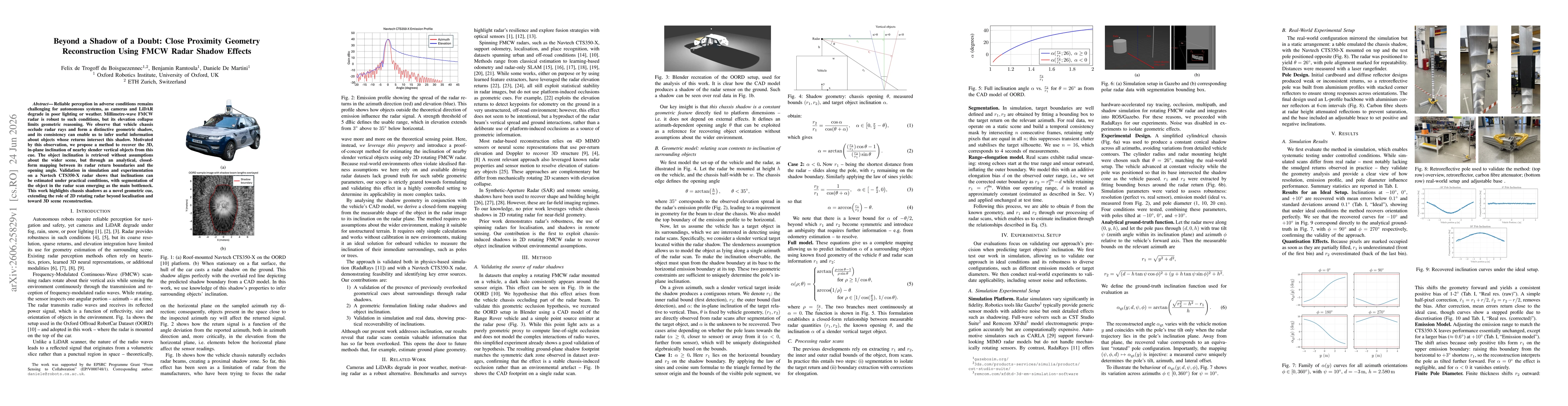
02
ResultsWhat they found
  • In simulation, the proposed mapping achieves near-ideal accuracy with mean errors below 0.7 degrees after quantisation correction.
  • In real data, inclination estimates are feasible but exhibit higher variability (roughly 3–4 degrees) due to segmentation noise and reflection variability.
  • The method can distinguish between an upright pole (0 degrees) and a significantly leaning object (>10 degrees), indicating utility for basic traversability assessment.
  • Elongation bias and calibration limitations contribute to uncertainty, but the closed-form relationship remains the core source of geometric information from radar shadows.
03
SignificanceWhy it matters

Introduces chassis-induced radar shadows as a novel geometric cue for near-field 3D geometry understanding with 2D rotating FMCW radars, expanding radar utility beyond localization toward 3D scene reconstruction under adverse conditions.

04
Technical ContributionsWhat's new technically

A closed-form analytic mapping between radar shadow boundaries caused by vehicle chassis occlusion and the inclination of nearby slender vertical objects, validated in both physics-based simulation and real radar data without relying on environmental priors.

05
NoveltyWhat sets it apart

First work to exploit chassis-induced shadows in 2D rotating FMCW radar for near-field geometric inference, enabling estimation of object inclination without assumptions about the wider scene.

06
LimitationsWhat to be cautious about
  • Segmentation quality of the target in the radar scan is the main practical bottleneck limiting accuracy in real data.
  • Real-world performance is hampered by signal strength, reflection variability, and illumination bias, yielding larger errors than in simulation.
  • Experiments used a controlled pole target and static setup, which may not fully generalize to natural objects with complex reflections.
  • Calibration constraints and the elongation bias introduce additional uncertainty, particularly at shorter ranges.
07
Future WorkWhere it goes next
  • Develop robust segmentation and detection pipelines, potentially using advanced deep learning to improve target delineation in radar scans.
  • Extend the method to generic objects without reflection-specific structures, and test under diverse ground planes and dynamic driving conditions.
  • Investigate non-calibrated or learning-based estimation approaches to reduce reliance on precise range and angle calibration.
  • Explore adaptive occluding masks or radar geometry adjustments to optimize θ for different range regimes and improve robustness.

Paper Details

Paper ID: 2606.25829
Categories:
cs.RO

How to Cite This Paper

Reference manager: RIS EndNote

Related Papers

4 found


Discussion 0

This website uses cookies to ensure you get the best experience. Learn more