Beyond Land Surface Temperature: Explainable Spatial Machine Learning Reveals Urban Morphology Effects on Human-Centric Heat Stress
Publication
Metrics
AI Quick Summary
The study shows that land surface temperature (LST) and physiologically relevant heat stress (UTCI) vary spatially in Singapore, with LST poorly capturing shading and radiative effects that drive human heat stress. Using a GPU-accelerated, explainable modeling framework (GW-XGBoost and SHAP-GAM), it reveals key urban factors like sky view and albedo differently shape LST and UTCI, underscoring the need to use human-centered thermal metrics for climate-adaptive urban planning.
Paper Preview
Abstract
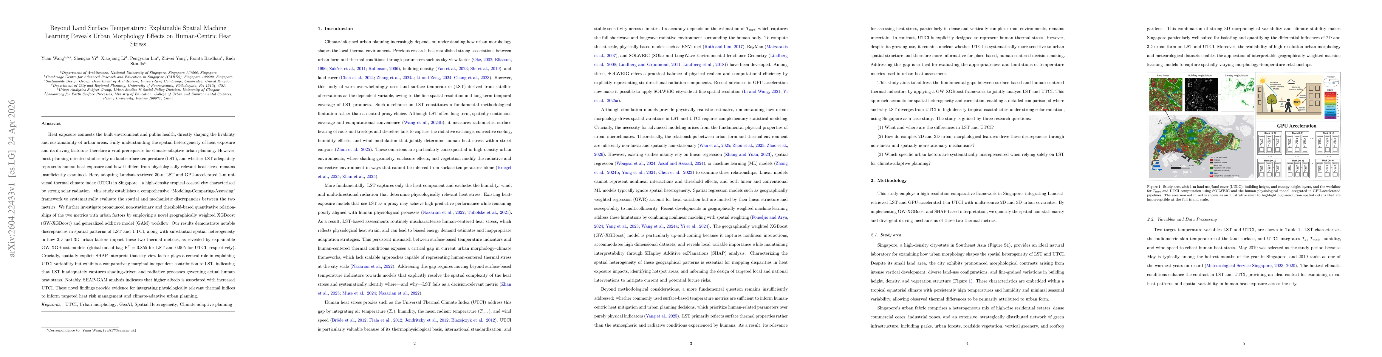
Heat exposure connects the built environment and public health, directly shaping the livability and sustainability of urban areas. Understanding the spatial heterogeneity of heat exposure and its drivers is vital for climate-adaptive urban planning. However, most planning-oriented studies rely on land surface temperature (LST), and whether LST adequately represents human heat exposure and how it differs from physiologically relevant heat stress remains insufficiently examined. Here, adopting Landsat-retrieved 30-m LST and GPU-accelerated 1-m universal thermal climate index (UTCI) in Singapore, this study establishes a comprehensive "Modeling-Comparing-Assessing" framework to systematically evaluate the spatial and mechanistic discrepancies between the two metrics. We further investigate pronounced non-stationary and threshold-based quantitative relationships of the two metrics with urban factors by employing a novel geographically weighted XGBoost (GW-XGBoost) and generalized additive model (GAM) workflow. Our results demonstrate notable discrepancies in spatial patterns of LST and UTCI, along with substantial spatial heterogeneity in how 2D and 3D urban factors impact these two thermal metrics, as revealed by explainable GW-XGBoost models (global out-of-bag R2 = 0.855 for LST and 0.905 for UTCI, respectively). Crucially, spatially explicit SHAP interprets that sky view factor plays a central role in explaining UTCI variability but exhibits a comparatively marginal independent contribution to LST, indicating that LST inadequately captures shading-driven and radiative processes governing actual human heat stress. Notably, SHAP-GAM analysis indicates that higher albedo is associated with increased UTCI. These novel findings provide evidence for integrating physiologically relevant thermal indices to inform targeted heat risk management and climate-adaptive urban planning.
AI Key Findings
Get AI-generated insights about this paper's methodology, results, significance, and more — seven facets brought into focus.
Discussion 0