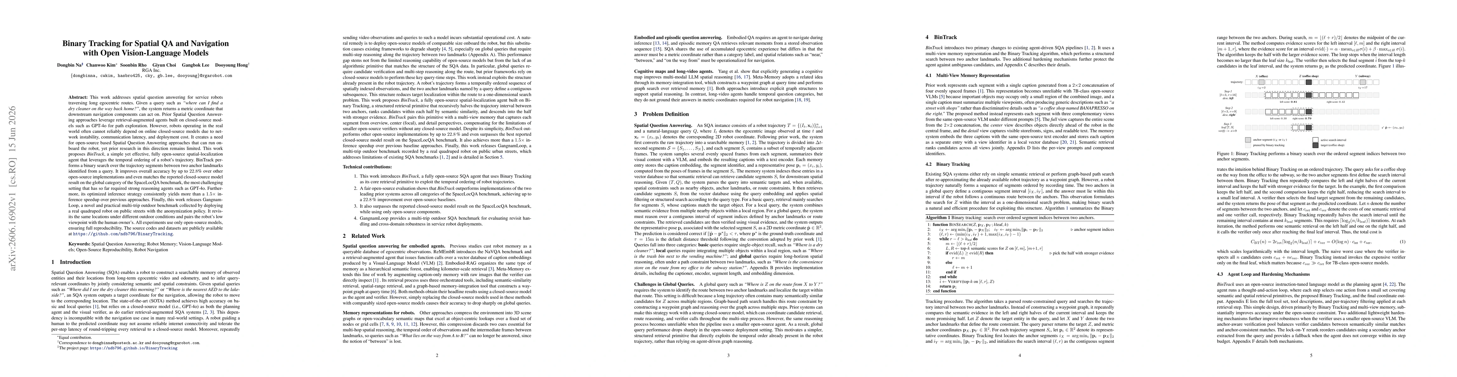
BinTrack is a fully open-source spatial-localization agent that leverages the temporal ordering of robot trajectories to perform a binary search over trajectory segments between two anchor landmarks identified by a query. It pairs this primitive with a multi-view memory (overview, center, detail perspectives) and uses a verifier ensemble over candidate segments to determine the correct segment. The system uses open-source components for memory representations, captioning, embeddings, and visual-language verification, and does not rely on closed-source models. Inference follows a hierarchical retrieval process: semantic similarity (SSR) to rank segments, followed by spatial ranking (SRR) within halves, descending into the half with stronger evidence, and concluding with verifier calls to validate candidates.
Binary Tracking for Spatial QA and Navigation with Open Vision-Language Models
Publication
Metrics
AI Quick Summary
BinTrack presents an open-source spatial-question-answering agent that localizes targets by binary-searching along a robot’s trajectory between two landmarks, enabling onboard reasoning without cloud models. It achieves up to 22.8% higher accuracy than other open-source methods, matches closed-source performance on hard SpaceLocQA tasks, speeds up inference by over 1.5x, and is validated on the GangnamLoop outdoor benchmark collected from real robots.
Quick Answers
What is "Binary Tracking for Spatial QA and Navigation with Open Vision-Language Models" about?
BinTrack presents an open-source spatial-question-answering agent that localizes targets by binary-searching along a robot’s trajectory between two landmarks, enabling onboard reasoning without cloud models. It achieves up to 22.8% higher accuracy than other open-source methods, matches closed-source performance on hard SpaceLocQA tasks, speeds up inference by over 1.5x, and is validated on the GangnamLoop outdoor benchmark collected from real robots.
What methodology did the authors use?
BinTrack is a fully open-source spatial-localization agent that leverages the temporal ordering of robot trajectories to perform a binary search over trajectory segments between two anchor landmarks identified by a query. It pairs this primitive with a multi-view memory (overview, center, detail perspectives) and uses a verifier ensemble over candidate segments to determine the correct segment. The system uses open-source... More in Methodology →
What are the key results?
BinTrack achieves up to 22.8% improvement over open-source baselines on SpaceLocQA, and matches the closed-source model performance on the global query category. — Inference speed is consistently boosted by more than 1.5x compared to prior open-source approaches. More in Key Results →
Why is this work significant?
The work demonstrates that an open-source, trajectory-structured retrieval primitive (BinaryTracking) can rival closed-source models for spatial question answering in robotic navigation, enabling onboard reasoning with comparable accuracy and substantially faster inference, which is crucial for real-time service-robot deployments. More in Significance →
What are the main limitations?
Cross-trajectory integration is naive in this work; a principled method for aligning and combining segments across multiple trajectories remains as future work. — Memory-building for new routes still requires offline captioning/embedding, presenting a practical barrier to fully online deployment. More in Limitations →
Paper Preview
Abstract
This work addresses spatial question answering for service robots traversing long egocentric routes. Given a query such as "where can I find a dry cleaner on the way back home?", the system returns a metric coordinate that downstream navigation components can act on. Prior Spatial Question Answering approaches leverage retrieval-augmented agents built on closed-source models such as GPT-4o for path exploration. However, robots operating in the real world often cannot reliably depend on online closed-source models due to network instability, communication latency, and deployment cost. It creates a need for open-source based Spatial Question Answering approaches that can run onboard the robot, yet prior research in this direction remains limited. This work proposes BinTrack, a simple yet effective, fully open-source spatial-localization agent that leverages the temporal ordering of a robot's trajectory. BinTrack performs a binary search over the trajectory segments between two anchor landmarks identified from a query. It improves overall accuracy by up to 22.8% over other open-source implementations and even matches the reported closed-source model result on the global category of the SpaceLocQA benchmark, the most challenging setting that has so far required strong reasoning agents such as GPT-4o. Furthermore, its optimized inference strategy consistently yields more than a 1.5x inference speedup over previous approaches. Finally, this work releases GangnamLoop, a novel and practical multi-trip outdoor benchmark collected by deploying a real quadruped robot on public streets with the anonymization policy. It revisits the same locations under different outdoor conditions and pairs the robot's low viewpoint with the human owner's. The source codes and datasets are publicly available at https://github.com/ndb796/BinaryTracking
Key Findings, in focus
Seven facets of this paper, analysed and brought into focus by AI.
The work demonstrates that an open-source, trajectory-structured retrieval primitive (BinaryTracking) can rival closed-source models for spatial question answering in robotic navigation, enabling onboard reasoning with comparable accuracy and substantially faster inference, which is crucial for real-time service-robot deployments.
- BinTrack achieves up to 22.8% improvement over open-source baselines on SpaceLocQA, and matches the closed-source model performance on the global query category.
- Inference speed is consistently boosted by more than 1.5x compared to prior open-source approaches.
- All experiments are conducted with open-source components, ensuring reproducibility and onboard deployability without external APIs.
The work demonstrates that an open-source, trajectory-structured retrieval primitive (BinaryTracking) can rival closed-source models for spatial question answering in robotic navigation, enabling onboard reasoning with comparable accuracy and substantially faster inference, which is crucial for real-time service-robot deployments.
Introduction of BinTrack as a new open-source retrieval primitive (BinaryTracking) that recursively halves trajectory intervals between anchor landmarks guided by semantic similarity, combined with a multi-view memory and verifier ensemble to produce 2D target coordinates for navigation.
First fully open-source spatial-localization agent that matches or surpasses closed-source baselines on SpaceLocQA by exploiting trajectory structure through BinaryTracking, while delivering substantial inference speedups and providing GangnamLoop as a new multi-trip outdoor benchmark.
- Cross-trajectory integration is naive in this work; a principled method for aligning and combining segments across multiple trajectories remains as future work.
- Memory-building for new routes still requires offline captioning/embedding, presenting a practical barrier to fully online deployment.
- The evaluation focuses on SpaceLocQA; generalization to broader SQA benchmarks and diverse environments may require further validation.
- Develop principled cross-trajectory integration to align and fuse segments from multiple trajectories before retrieval.
- Investigate online memory construction methods to minimize offline captioning costs for unseen routes.
- Extend evaluation to additional SQA benchmarks and real-world deployment scenarios to assess robustness across domains and conditions.
Discussion 0