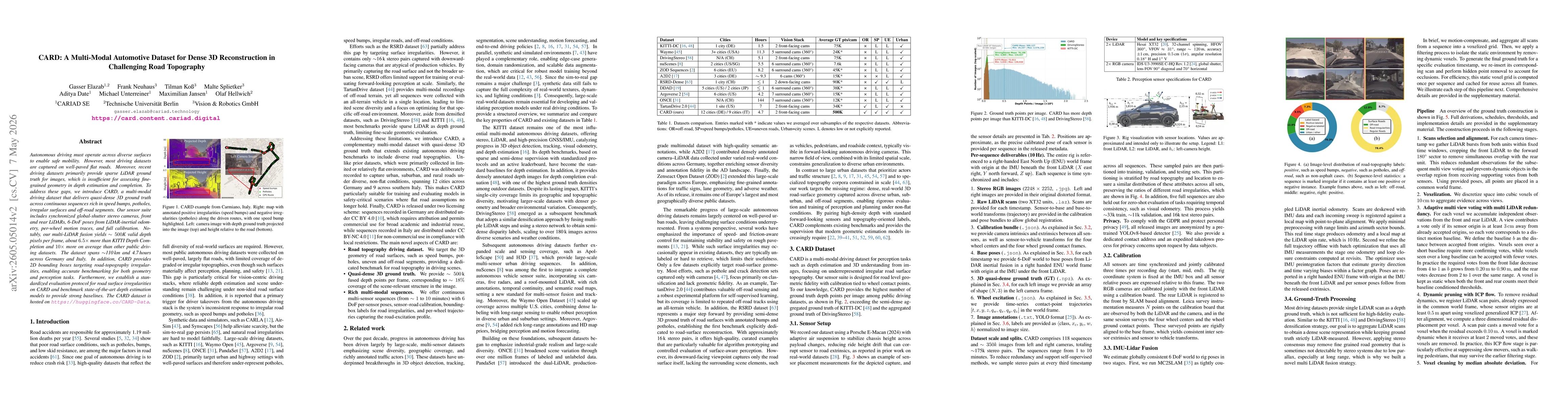
CARD collects a multi-modal driving dataset with synchronized global-shutter stereo cameras, front and rear LiDARs, 6-DoF poses from LiDAR-inertial odometry, per-wheel motion traces, and full calibration to produce quasi-dense 3D ground truth (~500K depth pixels per frame) across diverse road topographies including speed bumps, potholes, irregular surfaces, and off-road segments, spanning ~110 km and 4.7 hours across Germany and Italy, accompanied by 2D bounding boxes for road irregularities and a standardized evaluation protocol for benchmarking depth estimation models.
CARD: A Multi-Modal Automotive Dataset for Dense 3D Reconstruction in Challenging Road Topography
Publication
Metrics
Quick Answers
What methodology did the authors use?
CARD collects a multi-modal driving dataset with synchronized global-shutter stereo cameras, front and rear LiDARs, 6-DoF poses from LiDAR-inertial odometry, per-wheel motion traces, and full calibration to produce quasi-dense 3D ground truth (~500K depth pixels per frame) across diverse road topographies including speed bumps, potholes, irregular surfaces, and off-road segments, spanning ~110 km and 4.7 hours across Germany and Italy,... More in Methodology →
What are the key results?
Multi-LiDAR fusion yields ~500K valid depth pixels per frame, about 6.5x more than KITTI Depth Completion and 10x more than other public driving datasets. — CARD provides quasi-dense 3D ground truth across continuous sequences with rich road-topography irregularities enabling fine-grained geometry benchmarks. More in Key Results →
Why is this work significant?
Addresses critical gaps in autonomous-driving benchmarks by delivering dense 3D ground truth over diverse, non-flat topographies, enabling robust evaluation of depth estimation, completion, and road-surface understanding in realistic driving scenarios. More in Significance →
What are the main limitations?
Geographic coverage, while spanning 12 German cities and 9 Italian sites, may still underrepresent certain topographies or weather conditions. — Quasi-dense depth is not as dense as full dense ground truth in all regions, potentially leaving small-scale geometries underrepresented. More in Limitations →
Abstract
Autonomous driving must operate across diverse surfaces to enable safe mobility. However, most driving datasets are captured on well-paved flat roads. Moreover, recent driving datasets primarily provide sparse LiDAR ground truth for images, which is insufficient for assessing fine-grained geometry in depth estimation and completion. To address these gaps, we introduce CARD, a multi-modal driving dataset that delivers quasi-dense 3D ground truth across continuous sequences rich in speed bumps, potholes, irregular surfaces and off-road segments. Our sensor suite includes synchronized global-shutter stereo cameras, front and rear LiDARs, 6-DoF poses from LiDAR-inertial odometry, per-wheel motion traces, and full calibration. Notably, our multi-LiDAR fusion yields ~500K valid depth pixels per frame, about 6.5x more than KITTI Depth Completion and 10x more on average than other public driving datasets. The dataset spans ~110 km and 4.7 hours across Germany and Italy. In addition, CARD provides 2D bounding boxes targeting road-topography irregularities, enabling accurate benchmarking for both geometry and perception tasks. Furthermore, we establish a standardized evaluation protocol for road surface irregularities on CARD and benchmark state-of-the-art depth estimation models to provide strong baselines. The CARD dataset is hosted on https://huggingface.co/CARD-Data.
Key Findings, in focus
Seven facets of this paper, analysed and brought into focus by AI.
Addresses critical gaps in autonomous-driving benchmarks by delivering dense 3D ground truth over diverse, non-flat topographies, enabling robust evaluation of depth estimation, completion, and road-surface understanding in realistic driving scenarios.
- Multi-LiDAR fusion yields ~500K valid depth pixels per frame, about 6.5x more than KITTI Depth Completion and 10x more than other public driving datasets.
- CARD provides quasi-dense 3D ground truth across continuous sequences with rich road-topography irregularities enabling fine-grained geometry benchmarks.
- Standardized evaluation protocol and baseline benchmarking established using state-of-the-art depth estimation models to facilitate cross-dataset comparisons.
Addresses critical gaps in autonomous-driving benchmarks by delivering dense 3D ground truth over diverse, non-flat topographies, enabling robust evaluation of depth estimation, completion, and road-surface understanding in realistic driving scenarios.
A publicly hosted, multi-modal driving dataset CARD with synchronized stereo cameras, LiDARs, 6-DoF sensor poses, per-wheel traces, and full calibration; quasi-dense 3D ground truth (~500K depth pixels per frame); road-topography focused annotations; and standardized evaluation protocols plus baseline depth-estimation benchmarks.
First large-scale, multi-modal driving dataset emphasizing dense 3D fusion over challenging non-flat road topographies, with continuous sequences, per-wheel metrics, and road irregularity annotations to support both geometry and perception tasks beyond traditional flat-road datasets.
- Geographic coverage, while spanning 12 German cities and 9 Italian sites, may still underrepresent certain topographies or weather conditions.
- Quasi-dense depth is not as dense as full dense ground truth in all regions, potentially leaving small-scale geometries underrepresented.
- Licensing differences between Germany (CC BY 4.0) and Italy (CC BY-NC 4.0) may constrain some commercial-use scenarios.
- Extend geographic and environmental coverage to additional countries and weather conditions.
- Improve end-to-end baselines with domain adaptation to bridge CARD with existing datasets.
- Explore per-wheel motion traces for dynamic surface interaction modeling and motion-aware depth completion.
- Enhance depth densification techniques to approach true dense ground truth while preserving computational efficiency.
Discussion 0