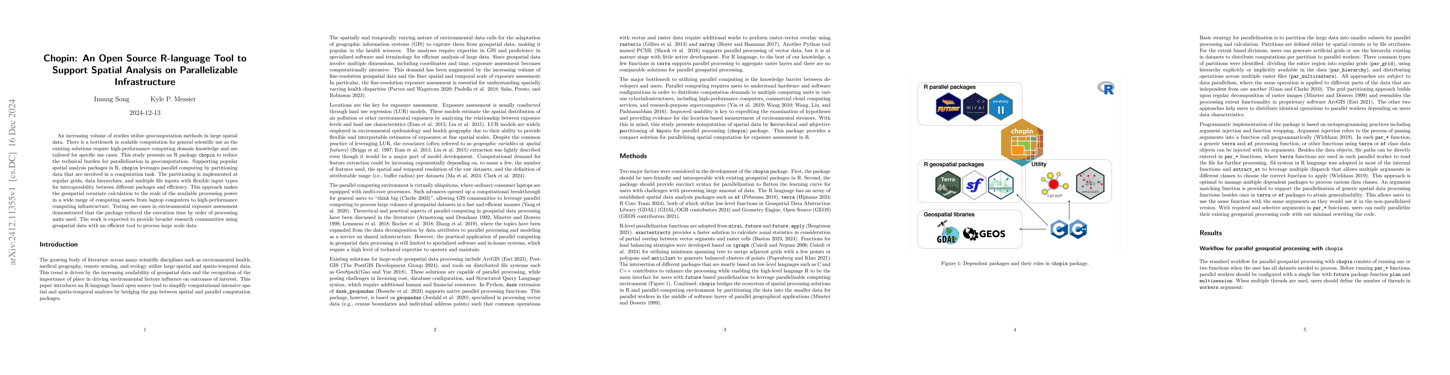
The paper introduces `chopin`, an R package designed to facilitate scalable parallel computation for spatial analysis in geocomputation, thus alleviating the technical barrier for users. It effectively partitions data for parallel processing, supporting various spatial analysis packages and optimizing execution time on a range of computing infrastructures.
An increasing volume of studies utilize geocomputation methods in large spatial data. There is a bottleneck in scalable computation for general scientific use as the existing solutions require high-performance computing domain knowledge and are tailored for specific use cases. This study presents an R package `chopin` to reduce the technical burden for parallelization in geocomputation. Supporting popular spatial analysis packages in R, `chopin` leverages parallel computing by partitioning data that are involved in a computation task. The partitioning is implemented at regular grids, data hierarchies, and multiple file inputs with flexible input types for interoperability between different packages and efficiency. This approach makes the geospatial covariate calculation to the scale of the available processing power in a wide range of computing assets from laptop computers to high-performance computing infrastructure. Testing use cases in environmental exposure assessment demonstrated that the package reduced the execution time by order of processing units used. The work is expected to provide broader research communities using geospatial data with an efficient tool to process large scale data.
Get AI-generated insights about this paper's methodology, results, and significance.
Current paper (gray), citations (green), references (blue)
Alfonso Sánchez-Macián, Jacobo Casado de Gracia
Alexis Palmer, Dananjay Srinivas, Marie Grace et al.
No citations found for this paper.
Title | Authors | Year | Actions |
---|---|---|---|
A review of geospatial exposure models and approaches for health data integration
|
Lara P. Clark, Daniel Zilber, Charles Schmitt, David C. Fargo, David M Reif, Alison A Motsinger-Reif, Kyle P Messier
|
2024
|
View Paper |
A comprehensive review of the development of land use regression approaches for modeling spatiotemporal variations of ambient air pollution: A perspective from 2011 to 2023.
|
Xuying Ma, Bin Zou, Jun Deng, Jay Gao, Ian Longley, Shun Xiao, Bin Guo, Yarui Wu, Tingting Xu, Xin Xu, Xiaosha Yang, Xiaoqi Wang, Zelei Tan, Yifan Wang, L. Morawska, Jennifer Salmond
|
2024
|
View Paper |
Hyper-local to regional exposure contrast of source-resolved PM2.5 components across the contiguous United States: implications for health assessment.
|
P. Saha, A. Presto, Allen L. Robinson
|
2023
|
View Paper |
Comparing containerization-based approaches for reproducible computational modeling of environmental systems
|
Youngdon Choi, Bina Roy, Jared Nguyen, Raza Ahmad, I. Maghami, Ayman Nassar, Zhiyu Li, A. Castronova, T. Malik, Shaowen Wang, J. Goodall
|
2023
|
View Paper |
Cloud-based storage and computing for remote sensing big data: a technical review
|
Chen Xu, Xiaoping Du, Xiangtao Fan, G. Giuliani, Zhong-Jian Hu, W. Wang, Jie Liu, Teng Wang, Zhenzhen Yan, Jun-jie Zhu, Tianyang Jiang, Huadong Guo
|
2022
|
View Paper |
Parallel algorithm for improving the performance of spatial queries in SQL: The use cases of SQLite/SpatiaLite and PostgreSQL/PostGIS databases
|
Mateusz Ilba
|
2021
|
View Paper |
The targets R package: a dynamic Make-like function-oriented pipeline toolkit for reproducibility and high-performance computing
|
Will Landau
|
2021
|
View Paper |
A Unifying Framework for Parallel and Distributed Processing in R using Futures
|
Henrik Bengtsson
|
2020
|
View Paper |
Next generation of GIS: must be easy
|
A. Zhu, Fang-He Zhao, Peng Liang, C. Qin
|
2020
|
View Paper |
Impact of regional versus local resolution air quality modeling on particulate matter exposure health impact assessment
|
Fatema Parvez, K. Wagstrom
|
2020
|
View Paper |
Parallel Processing Strategies for Big Geospatial Data
|
M. Werner
|
2019
|
View Paper |
Big Spatiotemporal Data Analytics: a research and innovation frontier
|
Chaowei Phil Yang, Keith Clarke, Shashi Shekhar, C. V. Tao
|
2019
|
View Paper |
Using anticlustering to partition data sets into equivalent parts.
|
Martin Papenberg, G. Klau
|
2019
|
View Paper |
An On-Demand Scalable Model for Geographic Information System (GIS) Data Processing in a Cloud GIS
|
Junqiang Zhang, Lirui Xu, Yi Zhang, Gang Liu, Lingjun Zhao, Yuzhu Wang
|
2019
|
View Paper |
A fork() in the road
|
Andrew Baumann, Jonathan Appavoo, Orran Krieger, Timothy Roscoe
|
2019
|
View Paper |
ONLINE GEOPROCESSING USING MULTI-DIMENSIONAL GRIDDED DATA
|
A. Kiran, P. Gupta, A. K. Jha, S. Saran
|
2018
|
View Paper |
CyberGIS‐Jupyter for reproducible and scalable geospatial analytics
|
Dandong Yin, Yan Y. Liu, Hao Hu, J. Terstriep, Xingchen Hong, Anand Padmanabhan, Shaowen Wang
|
2018
|
View Paper |
A Spark-Based Parallel Framework for Geospatial Raster Data Processing
|
Fan Gao, P. Yue
|
2018
|
View Paper |
IMPLEMENTATION OF A COMPREHENSIVE AND EFFECTIVE GEOPROCESSING WORKFLOW ENVIRONMENT
|
R. Lemmens, B. Toxopeus, L. Boerboom, M. Schouwenburg, B. Retsios, W. Nieuwenhuis, C. Mannaerts
|
2018
|
View Paper |
Effect of Model Spatial Resolution on Estimates of Fine Particulate Matter Exposure and Exposure Disparities in the United States
|
David A. Paolella, C. Tessum, P. Adams, J. Apte, Sarah E. Chambliss, Jason D. Hill, Nicholas Z. Muller, J. Marshall
|
2018
|
View Paper |
A geoprocessing framework to compute urban indicators: The MApUCE tools chain
|
E. Bocher, Gwendall Petit, Jérémy Bernard, Sylvain Palominos
|
2018
|
View Paper |
Parallel Agent-as-a-Service (P-AaaS) Based Geospatial Service in the Cloud
|
Xicheng Tan, Song Guo, L. Di, M. Deng, F. Huang, Xinyue Ye, Ziheng Sun, Weishu Gong, Z. Sha, S. Pan
|
2017
|
View Paper |
xarray: N-D labeled arrays and datasets in Python
|
Stephan Hoyer, J. Hamman
|
2017
|
View Paper |
Open cyberGIS software for geospatial research and education in the big data era
|
Shaowen Wang, Yan Y. Liu, Anand Padmanabhan
|
2016
|
View Paper |
Parallel cartographic modeling: a methodology for parallelizing spatial data processing
|
Eric Shook, M. Hodgson, Shaowen Wang, Babak Behzad, Kiumars Soltani, A. Hiscox, Jayakrishnan Ajayakumar
|
2016
|
View Paper |
Geospatial Big Data Handling Theory and Methods: A Review and Research Challenges
|
Songnian Li, S. Dragićević, François Anton, Monika Sester, Stephan Winter, A. Çöltekin, C. Pettit, Bin Jiang, J. Haworth, Alfred Stein, Tao Cheng
|
2015
|
View Paper |
Computation of geographic variables for air pollution prediction models in South Korea
|
Youngseob Eum, Insang Song, Hwan-Cheol Kim, J. Leem, Sun-Young Kim
|
2015
|
View Paper |
Land use regression models coupled with meteorology to model spatial and temporal variability of NO2 and PM10 in Changsha, China
|
Wu Liu, Xiaodong Li, Zuo Chen, G. Zeng, T. Leon, Jie Liang, G. Huang, Zhihua Gao, Sheng Jiao, Xiaoxiao He, Mingyong Lai
|
2015
|
View Paper |
Enabling Digital Earth simulation models using cloud computing or grid computing – two approaches supporting high-performance GIS simulation frameworks
|
I. Kim, Ming-Hsiang Tsou
|
2013
|
View Paper |
Integrating address geocoding, land use regression, and spatiotemporal geostatistical estimation for groundwater tetrachloroethylene.
|
K. Messier, Yasuyuki Akita, M. Serre
|
2012
|
View Paper |
Open-Source web-based geographical information system for health exposure assessment
|
B. Evans, C. Sabel
|
2012
|
View Paper |
A parallel computing approach to fast geostatistical areal interpolation
|
Qingfeng Guan, P. Kyriakidis, M. Goodchild
|
2011
|
View Paper |
Spatial cloud computing: how can the geospatial sciences use and help shape cloud computing?
|
Chaowei Yang, Michael F. Goodchild, Qunying Huang, Doug Nebert, Robert Raskin, Yan Xu, M. Bambacus, D. Fay
|
2011
|
View Paper |
A CyberGIS Framework for the Synthesis of Cyberinfrastructure, GIS, and Spatial Analysis
|
Shaowen Wang
|
2010
|
View Paper |
A general-purpose parallel raster processing programming library test application using a geographic cellular automata model
|
Qingfeng Guan, K. Clarke
|
2010
|
View Paper |
Grid‐enabling Geographically Weighted Regression: A Case Study of Participation in Higher Education in England
|
Richard J. Harris, A. Singleton, D. Grose, C. Brunsdon, P. Longley
|
2010
|
View Paper |
Geocomputation's future at the extremes: high performance computing and nanoclients
|
K. Clarke
|
2003
|
View Paper |
Parallel processing for geographical applications: A layered approach
|
M. Mineter, S. Dowers
|
1999
|
View Paper |
Mapping Urban Air Pollution Using GIS: A Regression-Based Approach
|
D. Briggs, S. Collins, P. Elliott, P. Fischer, S. Kingham, E. Lebret, K. Pryl, H. V. Reeuwijk, K. Smallbone, A. V. D. Veen
|
1997
|
View Paper |
Spatial Strategies for Parallel Spatial Modelling
|
Yuemin Ding, P. Densham
|
1996
|
View Paper |
DOMAIN DECOMPOSITION FOR PARALLEL PROCESSING OF SPATIAL PROBLEMS
|
M. Armstrong, P. Densham
|
1992
|
View Paper |
Speedup Versus Efficiency in Parallel Systems
|
D. Eager, J. Zahorjan, Ed Lazowska
|
1989
|
View Paper |
Validity of the single processor approach to achieving large scale computing capabilities
|
G. Amdahl
|
1967
|
View Paper |
cuSpatial: GPU-Accelerated Geospatial and Spatiotemporal Algorithms. Version 25.04 [software]
|
2025
|
||
Rmpi: Interface (Wrapper) to MPI (Message-Passing Interface). Version 0.7-3.3 [software]
|
2025
|
||
GeoWombat: utilities for geospatial data. Version 2.1.22 [software]
|
2024
|
||
The PostGIS Development Group
|
2024
|
||
Extent (Environment Setting)
|
2021
|
||
“geopandas: V0.8.1.”
|
2020
|
||
Task 51 - Cloud-Optimized Format Study
|
2020
|
||
Advanced R. 2 nd ed
|
2019
|
||
Simple Features for R: Standardized Support for Spatial Vector Data
|
E. Pebesma
|
2018
|
View Paper |
“Tigris: Load Census TIGER/Line Shapefiles.”
|
2015
|
||
“Rasterio: Geospatial Raster I/O for Python Programmers.”
|
2013
|
||
Parallel R: Data Analysis in the Distributed World
|
2012
|
||
The igraph software package for complex network research
|
Gábor Csárdi, T. Nepusz
|
2006
|
View Paper |
Grid Computing for Real Time Distributed Collaborative Geoprocessing
|
Yi Shi, Ashton M. Shortridge, Jon Bartholic
|
2002
|
View Paper |
U . S . Census Bureau
|
R. Lamacchia, Catherine L. Miller, Leo B. Dougherty, William G. Barron, J. H. Thompson, Preston J. Waite, Robert G. Marx, L. Franz, David E. Galdi, Carl S. Hantman, Carola Horn
|
2001
|
View Paper |
Point of Contact: Kyle P Messier [aut, ctb], kyle
|
|||
Future.apply: Apply Function to Elements in Parallel using Futures. Version 1.11.3 [software]
|
|||
igraph: Network Analysis and Visualization in R. Version 2.1.2 [software]
|
|||
2024. R: A Language and Environment for Statistical Computing. Version 4.4.2 [software]
|
|||
R Core Team. 2024.
|
|||
National Land Cover Database (NLCD) 2021 Products
|
|||
Mirai: Minimalist Async Evaluation Framework for R. Version 1.3.1 [software]
|
|||
“A Machine Learning Approach for Predicting Computational Intensity and Domain Decomposition in Parallel Geopro-cessing.”
|
|||
Terra: Spatial Data Analysis. Version 1.8-5 [software]
|
|||
GeoWombat Contributors
|
|||
2023. exactextractr: Fast Extraction from Raster Datasets Using Polygons .
|
|||
future.mirai: A ’Future’ API for Parallel Processing Using ’mirai’. Version 0.2.2 [software]
|
|||
ArcGIS Pro. Version 3.4 [software]
|
|||
Bureau of Transportation Statistics
|
Showing first page preview. Click "Open Full PDF" to view the complete paper.
Your comment contains inappropriate language and has been rejected.
Are you sure you want to remove this tag? This action cannot be undone.
Someone just found a breakthrough paper!
Comments (0)