Cities and Regions in Britain through hierarchical percolation
Publication
Metrics
AI Quick Summary
This study applies hierarchical percolation theory to Britain's street network, revealing urban hierarchies at various scales. It identifies regional fractures, from natural boundaries to socio-economic divides, and aligns city clusters with satellite image boundaries, demonstrating the method's accuracy.
Paper Preview
Abstract
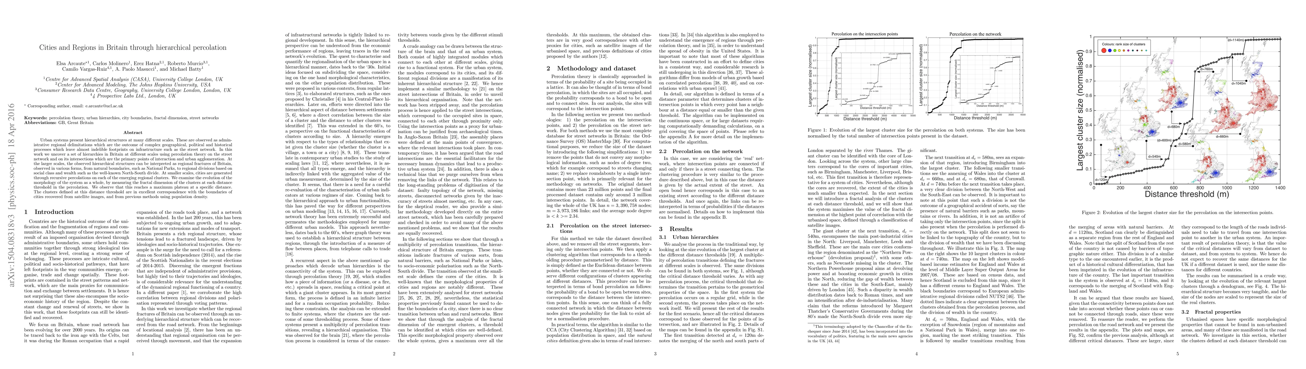
Urban systems present hierarchical structures at many different scales. These are observed as administrative regional delimitations which are the outcome of complex geographical, political and historical processes which leave almost indelible footprints on infrastructure such as the street network. In this work we uncover a set of hierarchies in Britain at different scales using percolation theory on the street network and on its intersections which are the primary points of interaction and urban agglomeration. At the larger scales, the observed hierarchical structures can be interpreted as regional fractures of Britain, observed in various forms, from natural boundaries, such as National Parks, to regional divisions based on social class and wealth such as the well-known North-South divide. At smaller scales, cities are generated through recursive percolations on each of the emerging regional clusters. We examine the evolution of the morphology of the system as a whole, by measuring the fractal dimension of the clusters at each distance threshold in the percolation. We observe that this reaches a maximum plateau at a specific distance. The clusters defined at this distance threshold are in excellent correspondence with the boundaries of cities recovered from satellite images, and from previous methods using population density.
AI Key Findings
Get AI-generated insights about this paper's methodology, results, significance, and more — seven facets brought into focus.
Impact
Paper Details
PDF Preview
Key Terms
Citation Network
Current paper (gray), citations (green), references (blue)
Display is limited for performance on very large graphs.
Discussion 0