Cliffs User Manual

Source: ArXiv

AI Quick Summary

Cliffs is an open-source numerical model for simulating tsunamis, featuring shallow-water approximation, grid nesting, and parallelization. It is available on GitHub and updated with code changes.

Share: Share on X LinkedIn

Summary

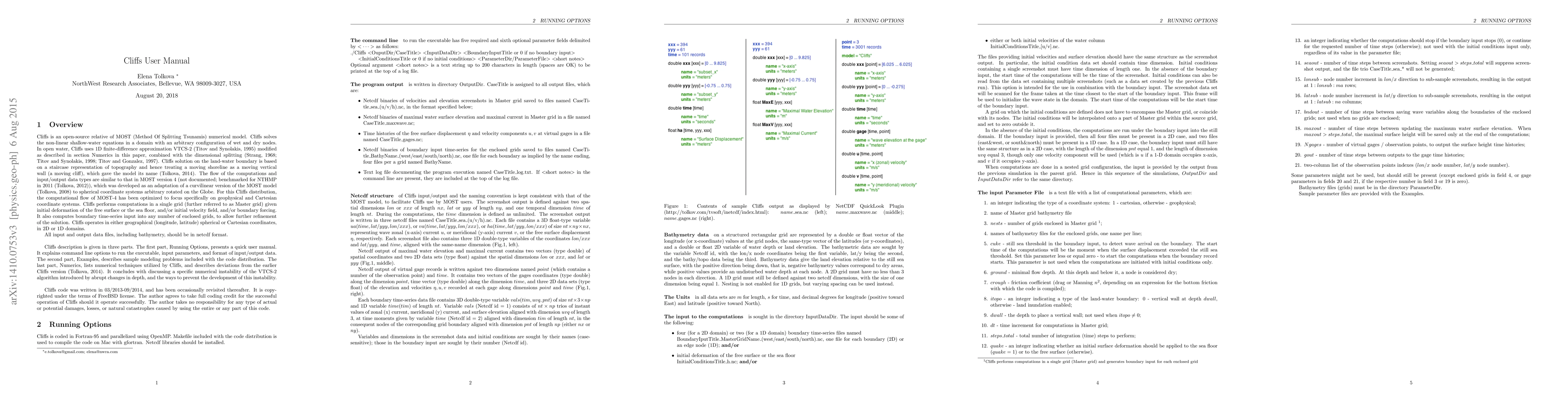
Cliffs is an open-source relative of MOST (Method Of Splitting Tsunamis) numerical model, implemented as described in (Tolkova, 2014, Pure and Appl. Geophys., 171(9), 2289-2314), with some modifications thereafter. Cliffs features: Shallow-Water approximation with an option to manipulate numerical dispersion; Use of Cartesian or spherical (lon/lat) coordinates; 1D and 2D configurations; Structured co-located grid with (optionally) varying spacing; Runup on land; Initial conditions or boundary forcing; Grid nesting with one-way coupling; Parallelized with OpenMP; NetCDF format of input/output data. This user manual accompanies Cliffs code distribution on GitHub, and is updated following essential updates to the code.

AI Key Findings

Generated Sep 05, 2025

Methodology

A numerical tsunami model was developed using the Method of Splitting Tsunami (MOST) method, which is a dimensionally split approach to solve the nonlinear shallow water equations.

Key Results

  • The MOST model was successfully applied to several benchmark cases, demonstrating its ability to accurately predict tsunami wave propagation and runup.
  • The model's performance was evaluated using various metrics, including wave amplitude, wave period, and runup height.
  • The results showed that the MOST model can capture the complex dynamics of tsunami waves, including non-breaking and breaking waves.

Significance

This research contributes to the development of a reliable numerical tsunami model that can be used for coastal hazard assessment and risk management.

Technical Contribution

The MOST model was implemented using a novel curvilinear grid system, which allows for better representation of complex coastal geometries.

Novelty

This research introduces a new numerical approach to solving the nonlinear shallow water equations, which can be applied to various coastal and oceanic phenomena.

Limitations

  • The model's accuracy is limited by the assumption of constant bottom topography and the use of a simplified wave friction parameterization.
  • The model's computational efficiency may not be suitable for high-resolution grid simulations or long-term predictions.

Future Work

  • Improving the model's accuracy by incorporating more advanced wave friction parameterizations and accounting for non-linear bottom topography.
  • Developing a parallel computing framework to enable efficient simulation of large-scale tsunami events.

Paper Details

PDF Preview

Download PDF

Key Terms

grid (0.265)
grid (0.262)
code (0.211)
lat (0.202)
code (0.200)
lat (0.189)
forcing (0.187)
format (0.185)

Citation Network

Current paper (gray), citations (green), references (blue)

Display is limited for performance on very large graphs.

Current Paper
Citations
References
Click to view

Similar Papers

Found 4 papers

hp3D User Manual

Leszek Demkowicz, Stefan Henneking

2023-09-22

PIETOOLS 2024: User Manual

Yulia Peet, Sachin Shivakumar, Matthew Peet et al.

2025-01-29
Title Authors Year Actions

Comments (0)

This website uses cookies to ensure you get the best experience. Learn more