ClusterRadar is an interactive web-tool designed for the multi-method exploration of spatial clusters over time, addressing the complexity of method selection and temporal tracking in spatial cluster analysis. Its interactive dashboard facilitates comparison and visualization of results from different clustering methods, enhancing temporal analysis and supporting various geospatial formats.
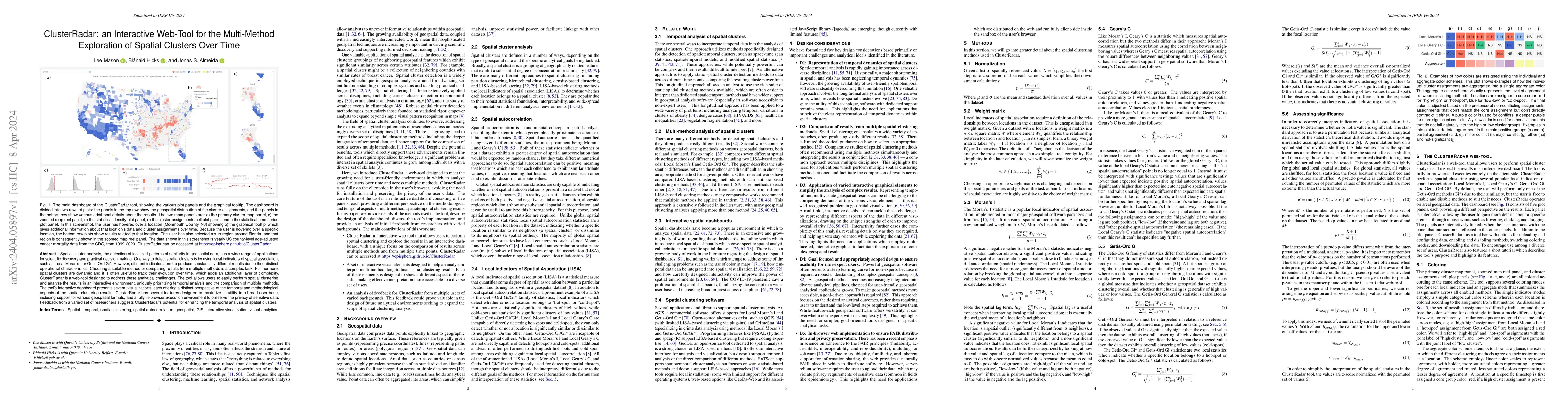
Spatial cluster analysis, the detection of localized patterns of similarity in geospatial data, has a wide-range of applications for scientific discovery and practical decision making. One way to detect spatial clusters is by using local indicators of spatial association, such as Local Moran's I or Getis-Ord Gi*. However, different indicators tend to produce substantially different results due to their distinct operational characteristics. Choosing a suitable method or comparing results from multiple methods is a complex task. Furthermore, spatial clusters are dynamic and it is often useful to track their evolution over time, which adds an additional layer of complexity. ClusterRadar is a web-tool designed to address these analytical challenges. The tool allows users to easily perform spatial clustering and analyze the results in an interactive environment, uniquely prioritizing temporal analysis and the comparison of multiple methods. The tool's interactive dashboard presents several visualizations, each offering a distinct perspective of the temporal and methodological aspects of the spatial clustering results. ClusterRadar has several features designed to maximize its utility to a broad user-base, including support for various geospatial formats, and a fully in-browser execution environment to preserve the privacy of sensitive data. Feedback from a varied set of researchers suggests ClusterRadar's potential for enhancing the temporal analysis of spatial clusters.
Get AI-generated insights about this paper's methodology, results, and significance.
Current paper (gray), citations (green), references (blue)
Mason, Lee, Hicks, Blánaid, Almeida, Jonas S
Ping Wang, Tianyi Li, Wenlong Zhang et al.
Guoxi Liu, Federico Iuricich, Xueyi Bao
Gabriel Kronberger, Fabricio Olivetti de Franca
No citations found for this paper.
Title | Authors | Year | Actions |
---|---|---|---|
Erratum: "Moving toward findable, accessible, interoperable, reusable practices in epidemiologic research".
|
Montserrat García-Closas, Thomas U Ahearn, M. Gaudet, Amber N. Hurson, J. Balasubramanian, P. Choudhury, Nicole M. Gerlanc, Bhaumik Patel, Daniel Russ, Mustapha Abubakar, Neal D Freedman, Wendy S W Wong, S. Chanock, Amy Berrington de González, Jonas S. Almeida
|
2024
|
View Paper |
Spatial data analysis
|
Tobias Ruttenauer
|
2024
|
View Paper |
Visualizing Large-Scale Spatial Time Series with GeoChron
|
Zikun Deng, Shifu Chen, T. Schreck, Dazhen Deng, Tan Tang, Mingliang Xu, Di Weng, Yingcai Wu
|
2023
|
View Paper |
Gridded Glyphmaps for Supporting Spatial COVID-19 Modelling
|
A. Slingsby, Richard Reeve, Claire Harris
|
2023
|
View Paper |
Measuring the inequalities in healthcare resource in facility and workforce: A longitudinal study in China
|
Enhong Dong, Xiaoting Sun, Ting Xu, Shixiang Zhang, Tao Wang, Lufa Zhang, W. Gao
|
2023
|
View Paper |
A Multiscale Geospatial Dataset and an Interactive Visualization Dashboard for Computational Epidemiology and Open Scientific Research
|
Muhammad Usman, Honglu Zhou, Seonghyeon Moon, Xun Zhang, P. Faloutsos, M. Kapadia
|
2022
|
View Paper |
Deploying geospatial visualization dashboards to combat the socioeconomic impacts of COVID-19
|
S. Praharaj, P. Solís, E. Wentz
|
2022
|
View Paper |
Introducing the FAIR Principles for research software
|
M. Barker, N. C. Chue Hong, D. Katz, Anna-Lena Lamprecht, Carlos Martinez-Ortiz, F. Psomopoulos, Jen Harrow, L. J. Castro, Morane Gruenpeter, P. Martínez, T. Honeyman
|
2022
|
View Paper |
Temporal Variations and Spatial Clusters of Dengue in Thailand: Longitudinal Study before and during the Coronavirus Disease (COVID-19) Pandemic
|
Sayambhu Saita, Sasithan Maeakhian, Tassanee Silawan
|
2022
|
View Paper |
Developing a Geospatial Framework for Severe Occupational Injuries Using Moran’s I and Getis-Ord Gi* Statistics for Southeastern United States
|
Md. Golam Rabbani Fahad, W. Zech, Rouzbeh Nazari, Maryam Karimi
|
2022
|
View Paper |
Comparing geospatial clustering methods to study spatial patterns of lung cancer rates in urban areas: A case study in Mashhad, Iran
|
Behzad Kiani, M. Fatima, Nazanin Hashemi Amin, Azam Hesami
|
2022
|
View Paper |
Methods Used in the Spatial and Spatiotemporal Analysis of COVID-19 Epidemiology: A Systematic Review
|
N. Nazia, Z. Butt, M. Bédard, Wang-Choi Tang, Hibah Sehar, J. Law
|
2022
|
View Paper |
On the nature, origins and outcomes of Over Featuring in the new product development process
|
Giacomo Marzi
|
2022
|
View Paper |
Applying Local Indicators of Spatial Association to Analyze Longitudinal Data: The Absolute Perspective
|
Ran Tao, Yuzhou Chen
|
2022
|
View Paper |
A Geo-Dashboard Concept for the Interactively Linked Visualization of Provenance and Data Quality for Geospatial Datasets
|
Heiko Figgemeier, Christin Henzen, Arne Rümmler
|
2021
|
View Paper |
Understanding data use and preference of data visualization for public health professionals: A qualitative study.
|
Seungeun Park, B. Bekemeier, A. Flaxman
|
2021
|
View Paper |
What are the Most Important Statistical Ideas of the Past 50 Years?
|
A. Gelman, Aki Vehtari
|
2020
|
View Paper |
A Review of Geospatial Content in IEEE Visualization Publications
|
Alexander Yoshizumi, Megan M. Coffer, Elyssa L. Collins, Mollie D. Gaines, Xiaojie Gao, K. Jones, I. McGregor, K. Mcquillan, Vinicius Perin, Laura M. Tomkins, Thomas J. Worm, Laura G. Tateosian
|
2020
|
View Paper |
Applications of GIS and geospatial analyses in COVID-19 research: A systematic review
|
R. Ahasan, Md. Shaharier Alam, Torit Chakraborty, M. Hossain
|
2020
|
View Paper |
An Introductory Framework for Choosing Spatiotemporal Analytical Tools in Population-Level Eco-Epidemiological Research
|
K. Kanankege, J. Álvarez, Lin Zhang, Andrés Perez
|
2020
|
View Paper |
Next generation of GIS: must be easy
|
A. Zhu, Fang-He Zhao, Peng Liang, C. Qin
|
2020
|
View Paper |
The Advantages of Comparative LISA Techniques in Spatial Inequality Research: Evidence from Poverty Change in the United States
|
Matthew M. Brooks
|
2019
|
View Paper |
Multivariate Maps - A Glyph-Placement Algorithm to Support Multivariate Geospatial Visualization
|
Liam McNabb, R. Laramee
|
2019
|
View Paper |
A Comparison of Visualizations for Identifying Correlation over Space and Time
|
Vanessa Peña Araya, Emmanuel Pietriga, A. Bezerianos
|
2019
|
View Paper |
Visual Analytics: A Comprehensive Overview
|
Wenqiang Cui
|
2019
|
View Paper |
Exploring the spatial patterns of vegetation fragmentation using local spatial autocorrelation indices
|
P. Kowe, O. Mutanga, J. Odindi, T. Dube
|
2019
|
View Paper |
Spatiotemporal Data Clustering: A Survey of Methods
|
Zhicheng Shi, L. Pun-Cheng
|
2019
|
View Paper |
Spatial Clusters of Breast Cancer Mortality and Incidence in the Contiguous USA: 2000–2014
|
R. Amin, Bridget A. Fritsch, John E. Retzloff
|
2019
|
View Paper |
Spatial clustering patterns of child weight status in a southeastern US county.
|
S. M. Hughey, A. Kaczynski, Dwayne E. Porter, J. Hibbert, G. Turner-McGrievy, Jihong Liu
|
2018
|
View Paper |
A Local Indicator of Multivariate Spatial Association: Extending Geary's
c
|
L. Anselin
|
2018
|
View Paper |
Comparing implementations of global and local indicators of spatial association
|
R. Bivand, David W. S. Wong
|
2018
|
View Paper |
Geospatial network analysis for healthcare facilities accessibility in semi-urban areas
|
Ilham Abd Jalil, Abdul Rauf Abdul Rasam, N. Adnan, N. M. Saraf, A. N. Idris
|
2018
|
View Paper |
Introduction to QGIS
|
N. Moyroud, F. Portet
|
2018
|
View Paper |
A Novel Hybrid Method for Measuring the Spatial Autocorrelation of Vehicular Crashes: Combining Moran’s Index and Getis-Ord G i * Statistic
|
A. Abdulhafedh
|
2017
|
View Paper |
GeoDa web: enhancing web-based mapping with spatial analytics
|
Xun Li, L. Anselin, Julia Koschinsky
|
2015
|
View Paper |
Interactivity and Cartography: A Contemporary Perspective on User Interface and User Experience Design from Geospatial Professionals
|
R. Roth
|
2015
|
View Paper |
Interactive and Multivariate Choropleth Maps with D3
|
C. Sack, Richard G. Donohue, R. Roth
|
2015
|
View Paper |
Cluster analysis applied to the spatial and temporal variability of monthly rainfall in Alagoas state, Northeast of Brazil
|
G. Lyra, J. F. Oliveira‐Júnior, Marcelo Zeri
|
2014
|
View Paper |
Spatial Clustering Overview and Comparison: Accuracy, Sensitivity, and Computational Expense
|
T. Grubesic, R. Wei, Alan T. Murray
|
2014
|
View Paper |
Do choropleth maps linked with parallel coordinates facilitate an understanding of multivariate spatial characteristics?
|
T. Opach, J. K. Rød
|
2014
|
View Paper |
Analyzing spatial clustering and the spatiotemporal nature and trends of HIV/AIDS prevalence using GIS: the case of Malawi, 1994-2010
|
L. Zulu, E. Kalipeni, Eliza Johannes
|
2014
|
View Paper |
SPATIAL CLUSTERING ALGORITHMS - AN OVERVIEW
|
Bindi Varghese, A. Unnikrishnan, K. PouloseJacob
|
2013
|
View Paper |
Exploring Hotspots of Drug Offences in Toronto: A Comparison of Four Local Spatial Cluster Detection Methods
|
Matthew Quick, J. Law
|
2013
|
View Paper |
A review of spatial methods in epidemiology, 2000-2010.
|
Amy H. Auchincloss, Samson Y. Gebreab, C. Mair, A. D. Diez Roux
|
2012
|
View Paper |
Analytical, visual and interactive concepts for geo-visual analytics
|
H. Schumann, C. Tominski
|
2011
|
View Paper |
Detection of spatial disease clusters with LISA functions
|
P. Moraga, F. Montes
|
2011
|
View Paper |
The Analysis of Spatial Association by Use of Distance Statistics
|
A. Getis
|
2010
|
View Paper |
Local Spatial Autocorrelation Statistics: Distributional Issues and an Application
|
J. Ord, A. Getis
|
2010
|
View Paper |
Local Indicators of Spatial Association—LISA
|
L. Anselin
|
2010
|
View Paper |
Explorative spatial analysis of traffic accident statistics and road mortality among the provinces of Turkey.
|
S. Erdogan
|
2009
|
View Paper |
Scanning for Clusters in Space and Time: : A Tutorial Review of SaTScan
|
R. Block
|
2007
|
View Paper |
Geovisual analytics for spatial decision support: Setting the research agenda
|
G. Andrienko, N. Andrienko, Piotr Jankowski, Daniel A. Keim, M. Kraak, A. Maceachren, Stefan Wrobel
|
2007
|
View Paper |
Tobler's First Law and Spatial Analysis
|
H. Miller
|
2004
|
View Paper |
Exploratory spatio-temporal visualization: an analytical review
|
N. Andrienko, G. Andrienko, P. Gatalsky
|
2003
|
View Paper |
Local clustering in breast, lung and colorectal cancer in Long Island, New York
|
G. Jacquez, D. Greiling
|
2003
|
View Paper |
Alcohol mortality: a comparison of spatial clustering methods.
|
Craig E Hanson, W. Wieczorek
|
2002
|
View Paper |
Interactivity Types in Geographic Visualization
|
J. Crampton
|
2002
|
View Paper |
Mapping Mortality: Evaluating Color Schemes for Choropleth Maps
|
Cynthia A. Brewer, A. Maceachren, L. Pickle, D. Herrmann
|
1997
|
View Paper |
GIS, spatial analysis and spatial statistics
|
D. Unwin
|
1996
|
View Paper |
Spatial disease clusters: detection and inference.
|
M. Kulldorff, Neville Nagarwalla
|
1995
|
View Paper |
A Computer Movie Simulating Urban Growth in the Detroit Region
|
W. Tobler
|
1970
|
View Paper |
The Contiguity Ratio and Statistical Mapping
|
Author R. C. Geary, R. Geary
|
1954
|
View Paper |
Notes on continuous stochastic phenomena.
|
P. Moran
|
1950
|
View Paper |
An Integrative Study Using Spatial Statistics and Racial/Ethnic Composition to Measure Racial/Ethnic Residential Segregation at Varying Scales
|
Y. Lin
|
2020
|
View Paper |
Geospatial dashboards for mapping and tracking of novel coronavirus pandemic
|
2020
|
||
Systematic Review of Geospatial Approaches to Breast Cancer Epidemiology
|
C. Thompson, S. Ilango, Joseph Gibbons, A. Nara, Ming-Hsiang Tsou
|
2019
|
View Paper |
Extending Moran's Index for Measuring Spatiotemporal Clustering of Geographic Events
|
J. Lee, Shengwen Li
|
2017
|
View Paper |
Spatial Scan Statistic
|
Pemetaan Jumlah Balita, Gizi Buruk, Di Kota, Surabaya dengan Gwnbr, dan Flexibly, Zuzun Miranti dan Purhadi
|
2014
|
View Paper |
Exploring the Influence of Colour Distance and Legend Position on Choropleth Maps Readability
|
Alzbeta Brychtová
|
2014
|
View Paper |
Spatial Statistics
|
Zhe Jiang
|
2013
|
View Paper |
Effective dashboard design
|
2013
|
||
PySAL: A Python Library of Spatial Analytical Methods
|
S. Rey, L. Anselin
|
2010
|
View Paper |
Spatial Statistics in ArcGIS
|
L. Scott, Mark V. Janikas
|
2010
|
View Paper |
Spatio-temporal clustering
|
S. Kisilevich, Florian Mansmann, M. Nanni, S. Rinzivillo
|
2010
|
View Paper |
Spatial Autocorrelation
|
D. Griffith
|
2009
|
View Paper |
GeoDa: An Introduction to Spatial Data Analysis
|
L. Anselin, I. Syabri, Youngihn Kho
|
2006
|
View Paper |
Spatial autocorrelation of cancer in Western Europe
|
M. Rosenberg, R. Sokal, N. Oden, D. Digiovanni
|
2004
|
View Paper |
The CrimeStat program: Characteristics, use and audience Geographical Analysis
|
2004
|
||
19 The Role of Spatial Analysis in Demographic Research
|
M. Goodchild, D. Janelle
|
2001
|
View Paper |
Invited commentary: the importance of descriptive epidemiology
|
Showing first page preview. Click "Open Full PDF" to view the complete paper.
Your comment contains inappropriate language and has been rejected.
Are you sure you want to remove this tag? This action cannot be undone.
Someone just favorited a paper!
Comments (0)