This paper introduces CMAB, the first national-scale multi-attribute building dataset in China, derived from open source data and GeoAI. The dataset, covering 3,667 cities and 21.3 billion square meters, includes detailed attributes for urban analysis and policy updates, validated for accuracy with a high F1-Score in rooftop extraction and extensive manual validation.
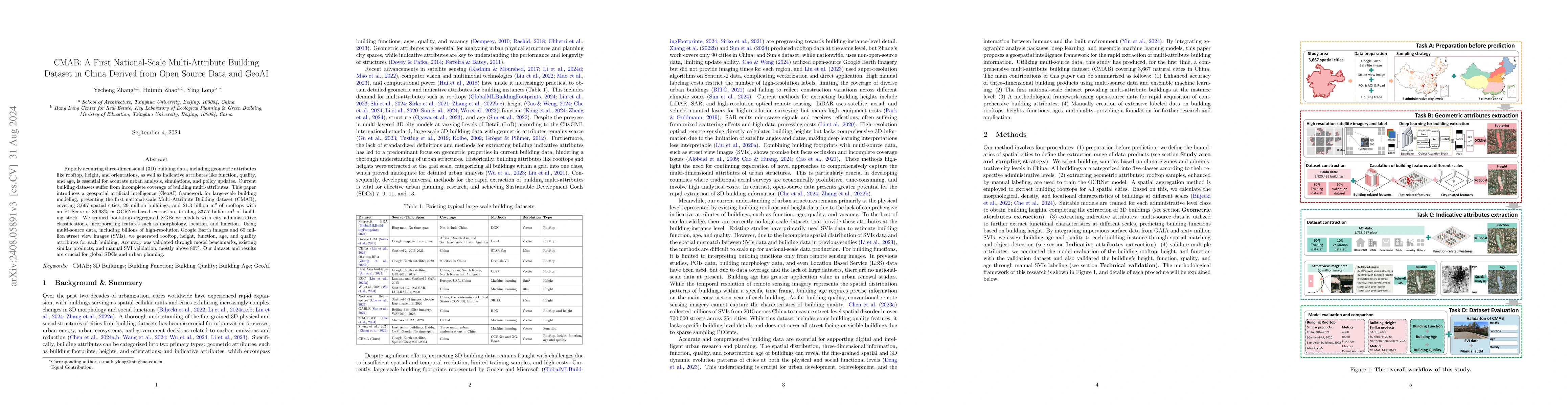
Rapidly acquiring three-dimensional (3D) building data, including geometric attributes like rooftop, height, and structure, as well as indicative attributes like function, quality, and age, is essential for accurate urban analysis, simulations, and policy updates. Existing large-scale building datasets lack accuracy, extensibility and indicative attributes. This paper presents a geospatial artificial intelligence (GeoAI) framework for large-scale building modeling, introducing the first Multi-Attribute Building dataset (CMAB) in China at a national scale. The dataset covers 3,667 natural cities with a total rooftop area of 21.3 billion square meters with an F1-Score of 89.93% in rooftop extraction through the OCRNet. We trained bootstrap aggregated XGBoost models with city administrative classifications, incorporating building features such as morphology, location, and function. Using multi-source data, including billions of high-resolution Google Earth imagery and 60 million street view images (SVI), we generated rooftop, height, function, age, and quality attributes for each building. Accuracy was validated through model benchmarks, existing similar products, and manual SVI validation. The results support urban planning and sustainable development.
Get AI-generated insights about this paper's methodology, results, and significance.
Current paper (gray), citations (green), references (blue)
No similar papers found for this research.
No citations found for this paper.
Title | Authors | Year | Actions |
---|---|---|---|
3D-GloBFP: the first global three-dimensional building footprint dataset
|
Yangzi Che, Xuecao Li, Xiaoping Liu, Yuhao Wang, Weilin Liao, Xianwei Zheng, Xucai Zhang, Xiaocong Xu, Qian Shi, Jiajun Zhu, Honghui Zhang, Hua Yuan, Yongjiu Dai
|
2024
|
View Paper |
A deep learning-based super-resolution method for building height estimation at 2.5 m spatial resolution in the Northern Hemisphere
|
Yinxia Cao, Qihao Weng
|
2024
|
View Paper |
Identifying building function using multisource data: A case study of China's three major urban agglomerations
|
Yue Zheng, Xucai Zhang, Jinpei Ou, Xiaoping Liu
|
2024
|
View Paper |
Measuring solar radiation and spatio-temporal distribution in different street network direction through solar trajectories and street view images
|
Lei Wang, Ce Hou, Yecheng Zhang, Jie He
|
2024
|
View Paper |
Refining urban morphology: An explainable machine learning method for estimating footprint-level building height
|
Yang Chen, Wen-Bin Sun, Ling Yang, Xin Yang, Xingyu Zhou, Xin Li, Sijin Li, Guoan Tang
|
2024
|
View Paper |
Rethinking demolition plans to fight neighborhood blight in shrinking cities: Applying agent-based policy simulations
|
Li Yin, Fuzhen Yin, R. M. Silverman
|
2024
|
View Paper |
A graph-based neural network approach to integrate multi-source data for urban building function classification
|
Bo Kong, Tinghua Ai, Xinyan Zou, Xiongfeng Yan, Min Yang
|
2024
|
View Paper |
GABLE: A first fine-grained 3D building model of China on a national scale from very high resolution satellite imagery
|
Xian Sun, Xingliang Huang, Yongqiang Mao, Taowei Sheng, Jihao Li, Zhirui Wang, Xue Lu, Xiaoliang Ma, Deke Tang, Kaiqiang Chen
|
2024
|
View Paper |
Rethinking the country-level percentage of population residing in urban area with a global harmonized urban definition
|
Wenyue Li, Yecheng Zhang, Mengxing Li, Ying Long
|
2024
|
View Paper |
City-scale solar PV potential estimation on 3D buildings using multi-source RS data: A case study in Wuhan, China
|
Zhe Chen, Bisheng Yang, Rui Zhu, Zhen Dong
|
2024
|
View Paper |
The last puzzle of global building footprints— mapping 280 million buildings in East Asia based on VHR images.
|
Qian Shi, Jiajun Zhu, Zhengyu Liu, Haonan Guo, Song Gao, Mengxi Liu, Zihong Liu, Xiaoping Liu
|
2024
|
View Paper |
Global Mapping of Three-Dimensional (3D) Urban Structures Reveals Escalating Utilization in the Vertical Dimension and Pronounced Building Space Inequality
|
Xiaoping Liu, Xinxin Wu, Xuecao Li, Xiaocong Xu, Weilin Liao, L. Jiao, Zhenzhong Zeng, Guangzhao Chen, Xia Li
|
2024
|
View Paper |
Multidisciplinary parameters for characterizing the 3D urban morphology: An overview based on the relational perspective
|
Kaixin Li, Hui Zeng
|
2024
|
View Paper |
Exploring urban building space provision and inequality: A three-dimensional perspective on Chinese Cities toward Sustainable Development Goals.
|
Xinxin Wu, Xiaocong Xu, Guangzhao Chen, Weilin Liao, Xiaoping Liu
|
2024
|
View Paper |
Protocol for assessing neighborhood physical disorder using the YOLOv8 deep learning model
|
Yan Li, Yue Ma, Ying Long
|
2023
|
View Paper |
Ensemble XGBoost schemes for improved compressive strength prediction of UHPC
|
May Huu Nguyen, Thuy-Anh Nguyen, H. Ly
|
2023
|
View Paper |
Large-scale urban building function mapping by integrating multi-source web-based geospatial data
|
Wei Chen, Yuyu Zhou, Eleanor C. Stokes, Xuesong Zhang
|
2023
|
View Paper |
Greening the Concrete Jungle: Unveiling the Co-Mitigation of Greenspace Configuration on PM2.5 and Land Surface Temperature with Explanatory Machine Learning
|
Yan Li, Yecheng Zhang, Qilin Wu, Ran Xue, Xiaoran Wang, Menglin Si, Yuyang Zhang
|
2023
|
View Paper |
The quality of OpenStreetMap food-related point-of-interest data for use in epidemiological research.
|
M. Pinho, Benjamin Flueckiger, Antònia Valentín, Maria-Iosifina Kasdagli, K. Kyriakou, J. Lakerveld, J. Mackenbach, J. Beulens, K. de Hoogh
|
2023
|
View Paper |
A spatio-temporal analysis investigating completeness and inequalities of global urban building data in OpenStreetMap
|
B. Herfort, S. Lautenbach, João Porto de Albuquerque, Jennings Anderson, A. Zipf
|
2023
|
View Paper |
Semi-supervised Learning from Street-View Images and OpenStreetMap for Automatic Building Height Estimation
|
Hao Li, Zhendong Yuan, G. Dax, G. Kong, H. Fan, A. Zipf, M. Werner
|
2023
|
View Paper |
A first Chinese building height estimate at 10 m resolution (CNBH-10 m) using multi-source earth observations and machine learning
|
Wanben Wu, Jun Ma, E. Banzhaf, M. Meadows, Zhaohan Yu, Fengxiang Guo, Dhritiraj Sengupta, Xingyu Cai, Bin Zhao
|
2023
|
View Paper |
Quality of crowdsourced geospatial building information: A global assessment of OpenStreetMap attributes
|
Filip Biljecki, Y. S. Chow, Kay Lee
|
2023
|
View Paper |
Automatizing the generation of building usage maps from geotagged street view images using deep learning
|
Surya Prasath Ramalingam, Vaibhav Kumar
|
2023
|
View Paper |
Elevation Estimation-Driven Building 3-D Reconstruction From Single-View Remote Sensing Imagery
|
Yongqiang Mao, Kaiqiang Chen, Liangjin Zhao, Wei Chen, Deke Tang, Wenjie Liu, Zhirui Wang, W. Diao, Xian Sun, Kun Fu
|
2023
|
View Paper |
Inferring building function: A novel geo-aware neural network supporting building-level function classification
|
Xucai Zhang, Xiaoping Liu, Kai Chen, Fangli Guan, Miao Luo, Haosheng Huang
|
2022
|
View Paper |
Measuring Physical Disorder in Urban Street Spaces: A Large-Scale Analysis Using Street View Images and Deep Learning
|
Jingjia Chen, Long Chen, Yan Li, Wenjia Zhang, Ying Long
|
2022
|
View Paper |
Urban spatial risk prediction and optimization analysis of POI based on deep learning from the perspective of an epidemic
|
Yecheng Zhang, Qimin Zhang, Yuxuan Zhao, Yunjie Deng, Hao Zheng
|
2022
|
View Paper |
Global Building Morphology Indicators
|
Filip Biljecki, Y. S. Chow
|
2022
|
View Paper |
Beyond single receptive field: A receptive field fusion-and-stratification network for airborne laser scanning point cloud classification
|
Yongqiang Mao, Kaiqiang Chen, W. Diao, Xian Sun, Xiaonan Lu, Kun Fu, M. Weinmann
|
2022
|
View Paper |
Urban Building Classification (UBC) – A Dataset for Individual Building Detection and Classification from Satellite Imagery
|
Xingliang Huang, Libo Ren, Chenglong Liu, Yixuan Wang, Hongfeng Yu, M. Schmitt, R. Hänsch, Xian Sun, Hai Huang, H. Mayer
|
2022
|
View Paper |
Identify urban building functions with multisource data: a case study in Guangzhou, China
|
Yingbin Deng, Renrong Chen, Ji Yang, Yong Li, Hao Jiang, Wenyue Liao, Meiwei Sun
|
2022
|
View Paper |
Vectorized rooftop area data for 90 cities in China
|
Zhixin Zhang, Zhen Qian, Teng Zhong, Min Chen, Kai Zhang, Yue Yang, Rui Zhu, Fan Zhang, Haoran Zhang, Fangzhuo Zhou, Jianing Yu, B. Zhang, Guonian Lü, Jinyue Yan
|
2022
|
View Paper |
Using Social Media Images for Building Function Classification
|
E. J. Hoffmann, Karam Abdulahhad, Xiao Xiang Zhu
|
2022
|
View Paper |
A hierarchical approach for fine-grained urban villages recognition fusing remote and social sensing data
|
Dongsheng Chen, Wei Tu, Rui Cao, Yatao Zhang, B. He, Chisheng Wang, Tiezhu Shi, Qingquan Li
|
2022
|
View Paper |
Integrating the Eigendecomposition Approach and k-Means Clustering for Inferring Building Functions with Location-Based Social Media Data
|
Feng Gao, Guanping Huang, Shaoying Li, Ziwei Huang, Lei Chai
|
2021
|
View Paper |
High-resolution mapping of mainland China’s urban floor area
|
Miao Liu, Jun Ma, Rui Zhou, Chunlin Li, Dikang Li, Yuanman Hu
|
2021
|
View Paper |
A deep learning method for building height estimation using high-resolution multi-view imagery over urban areas: A case study of 42 Chinese cities
|
Yinxia Cao, Xin Huang
|
2021
|
View Paper |
Continental-Scale Building Detection from High Resolution Satellite Imagery
|
Wojciech Sirko, S. Kashubin, Marvin Ritter, Abigail Annkah, Yasser Salah Edine Bouchareb, Yann Dauphin, Daniel Keysers, Maxim Neumann, Moustapha Cissé, John Quinn
|
2021
|
View Paper |
The effects of 2D and 3D building morphology on urban environments: A multi-scale analysis in the Beijing metropolitan region
|
Q. Cao, Q. Luan, Yupeng Liu, Ren-chao Wang
|
2021
|
View Paper |
IM2ELEVATION: Building Height Estimation from Single-View Aerial Imagery
|
Chao-Jung Liu, V. Krylov, P. Kane, Geraldine Kavanagh, Rozenn Dahyot
|
2020
|
View Paper |
Continental-scale mapping and analysis of 3D building structure
|
Mengmeng Li, E. Koks, H. Taubenböck, Jasper van Vliet
|
2020
|
View Paper |
Mapping global urban boundaries from the global artificial impervious area (GAIA) data
|
Xuecao Li, Peng Gong, Yuyu Zhou, Jie Wang, Yuqi Bai, Bin Chen, Tengyun Hu, Yixiong Xiao, Bing Xu, J. Yang, Xiaoping Liu, W. Cai, Huabing Huang, Tinghai Wu, Xi Wang, Peng Lin, Xun Li, Jin Chen, Chunyang He, Xia Li, Le Yu, N. Clinton, Zhiliang Zhu
|
2020
|
View Paper |
High-spatiotemporal-resolution mapping of global urban change from 1985 to 2015
|
Xiaoping Liu, Yinghuai Huang, Xiaocong Xu, Xuecao Li, Xia Li, P. Ciais, P. Lin, Kai Gong, A. Ziegler, Anping Chen, Peng Gong, Jun Chen, G. Hu, Yimin Chen, Shaojian Wang, Qiusheng Wu, Kangning Huang, L. Estes, Zhenzhong Zeng
|
2020
|
View Paper |
Functional urban area delineations of cities on the Chinese mainland using massive Didi ride-hailing records
|
Shuang Ma, Ying Long
|
2020
|
View Paper |
Combinational shadow index for building shadow extraction in urban areas from Sentinel-2A MSI imagery
|
Genyun Sun, Hui Huang, Qihao Weng, A. Zhang, X. Jia, Jinchang Ren, Lin Sun, Xiaolin Chen
|
2019
|
View Paper |
Effective Building Extraction From High-Resolution Remote Sensing Images With Multitask Driven Deep Neural Network
|
Jian Hui, M. Du, Xin Ye, Q. Qin, Juan Sui
|
2019
|
View Paper |
Creating 3D city models with building footprints and LIDAR point cloud classification: A machine learning approach
|
Yujin Park, J. Guldmann
|
2019
|
View Paper |
Estimating the Spatial Distribution of Vacant Houses Using Public Municipal Data
|
Y. Akiyama, Akihiro Ueda, Kenta Ouchi, N. Ito, Yoshiya Ono, Hideo Takaoka, Kohta Hisadomi
|
2019
|
View Paper |
Mapping changes in housing in sub-Saharan Africa from 2000 to 2015
|
L. Tusting, D. Bisanzio, G. Alabaster, E. Cameron, R. Cibulskis, M. Davies, S. Flaxman, H. Gibson, Jakob Bæk Tejs Knudsen, C. Mbogo, F. Okumu, L. von Seidlein, D. Weiss, S. Lindsay, P. Gething, S. Bhatt
|
2019
|
View Paper |
A global record of annual urban dynamics (1992–2013) from nighttime lights
|
Yuyu Zhou, Xuecao Li, G. Asrar, Steven J. Smith, M. Imhoff
|
2018
|
View Paper |
Live-Work-Play Centers of Chinese cities: Identification and temporal evolution with emerging data
|
Juan-Zi Li, Ying Long, A. Dang
|
2018
|
View Paper |
The morphology of the Arrival City - A global categorization based on literature surveys and remotely sensed data
|
H. Taubenböck, N. J. Kraff, M. Wurm
|
2018
|
View Paper |
Drought evolution, severity and trends in mainland China over 1961-2013.
|
Ning Yao, Yi Li, T. Lei, Lingling Peng
|
2018
|
View Paper |
Building Instance Classification Using Street View Images
|
Jian Kang, Marco Körner, Yuanyuan Wang, H. Taubenböck, Xiaoxiang Zhu
|
2018
|
View Paper |
HANZE: a pan-European database of exposure to natural hazards and damaging historical floods since 1870
|
D. Paprotny, O. Morales-Nápoles, S. Jonkman
|
2017
|
View Paper |
Generating 3D city models without elevation data
|
F. Biljecki, H. Ledoux, J. Stoter
|
2017
|
View Paper |
XGBoost: A Scalable Tree Boosting System
|
Tianqi Chen, Carlos Guestrin
|
2016
|
View Paper |
Vulnerability to heat waves: Impact of urban expansion scenarios on urban heat island and heat stress in Paris (France)
|
A. Lemonsu, V. Viguié, M. Daniel, V. Masson
|
2015
|
View Paper |
Mapping urban residential density patterns: Compact city model in Melbourne, Australia
|
P. Chhetri, J. Han, S. Chandra, J. Corcoran
|
2013
|
View Paper |
CityGML – Interoperable semantic 3D city models
|
Derek Lichti
|
2012
|
View Paper |
On Why Planning Should Not Reinforce Self-Reinforcing Trends: A Cautionary Analysis of the Compact-City Proposal Applied to Large Cities
|
António Ferreira, P. Batey
|
2011
|
View Paper |
Global urban land-use trends and climate impacts
|
K. Seto, J. M. Shepherd
|
2009
|
View Paper |
Bagging Predictors
|
L. Breiman
|
1996
|
View Paper |
A Review of Building Extraction From Remote Sensing Imagery: Geometrical Structures and Semantic Attributes
|
Qingyu Li, Lichao Mou, Yao Sun, Yuansheng Hua, Yilei Shi, Xiao Xiang Zhu
|
2024
|
View Paper |
CBRA: The first multi-annual (2016-2021) and high-resolution (2.5 m) building rooftop area dataset in China derived with Super-resolution Segmentation from Sentinel-2 imagery
|
Zeping Liu, Hong Tang, Lin Feng, Siqing Lyu
|
2023
|
View Paper |
Characterizing urban densification and quantifying its effects on urban thermal environments and human thermal comfort
|
X. Deng, Qian Cao, Lunche Wang, Wei Wang, Shuai Wang, Shaoqiang Wang, Lizhe Wang
|
2023
|
View Paper |
Deep Learning Approach for Classifying the Built Year and Structure of Individual Buildings by Automatically Linking Street View Images and GIS Building Data
|
Y. Ogawa, Chenbo Zhao, Takuya Oki, Shenglong Chen, Y. Sekimoto
|
2023
|
View Paper |
Associatively Segmenting Semantics and Estimating Height From Monocular Remote-Sensing Imagery
|
Wenjie Liu, Xian Sun, Wenkai Zhang, Zhi Guo, Kun Fu
|
2022
|
View Paper |
Identifying Urban Building Function by Integrating Remote Sensing Imagery and POI Data
|
Anqi Lin, Xiaomeng Sun, Hao Wu, Wenting Luo, Danyang Wang, Dantong Zhong, Zhongming Wang, Lanting Zhao, Jiang Zhu
|
2021
|
View Paper |
Dataset of building instances in typical Chinese cities [DB/OL]
|
2021
|
||
Annual maps of global artificial impervious area (GAIA) between 1985 and 2018
|
P. Gong, Xuecao Li, Jie Wang, Yuqi Bai, Bin Chen, Tengyun Hu, Xiaoping Liu, Bing Xu, Jun Yang, Wei Zhang, Yuyu Zhou
|
2020
|
View Paper |
A comprehensive assessment of climate change impacts on global flood risk
|
2020
|
||
Identifying Spatial Cities in China at the Community Scale
|
2019
|
||
A Shadow-Overlapping Algorithm for Estimating Building Heights From VHR Satellite Images
|
N. Kadhim, M. Mourshed
|
2018
|
View Paper |
Exploring the changes of building vulnerability and its implications for urban flood risk in Shanghai
|
2018
|
||
The Geometry of Urban Layouts: A Global Comparative Study
|
Mahbub Rashid
|
2017
|
View Paper |
The urban density assemblage: Modelling multiple measures
|
K. Dovey, Elek Pafka
|
2014
|
View Paper |
Revisiting the Compact City, Dempsey, N., (NOT FINAL PROOF) published in BUILT ENVIRONMENT VOL 36 NO 1, pp. 5-8
|
2010
|
||
Representing and Exchanging 3D City Models with CityGML
|
T. H. Kolbe
|
2009
|
View Paper |
BUILDING HEIGHT ESTIMATION IN URBAN AREAS FROM VERY HIGH RESOLUTION SATELLITE STEREO IMAGES
|
A. Alobeid, K. Jacobsen, C. Heipke
|
2009
|
View Paper |
An Introduction to the Bootstrap
|
2007
|
View Paper | |
Additive logistic regression: a statistical view of boosting (with discussion and a rejoinder by the authors)
|
2000
|
||
Understanding architecture age and style through deep learning
|
|||
Generative design method of building group based on AIP (Aging in Place) assessment: The case of dense urban renewal districts in Hong Kong
|
|||
Artificial intelligence prediction of urban spatial risk factors from an epidemic perspective
|
|||
Connecting people by proximity: A better way to plan metro areas
|
|||
S1: Time and area distribution of GES imagery for spatial cities
|
Showing first page preview. Click "Open Full PDF" to view the complete paper.
Your comment contains inappropriate language and has been rejected.
Are you sure you want to remove this tag? This action cannot be undone.
Someone just favorited a paper!
Comments (0)