Quick Summary:

The CME dataset aims to advance China map detection and standardization by providing a dedicated resource for identifying problematic maps, focusing on national sovereignty, territorial integrity, and compliance issues. This new dataset covers five key problem areas to support high-precision map compliance detection and enhance overall map data quality and timeliness.

Summary

Digital images of Chinas maps play a crucial role in map detection, particularly in ensuring national sovereignty, territorial integrity, and map compliance. However, there is currently no publicly available dataset specifically dedicated to problematic maps the CME dataset. Existing datasets primarily focus on general map data and are insufficient for effectively identifying complex issues such as national boundary misrepresentations, missing elements, and blurred boundaries. Therefore, this study creates a Problematic Map dataset that covers five key problem areas, aiming to provide diverse samples for problematic map detection technologies, support high-precision map compliance detection, and enhance map data quality and timeliness. This dataset not only provides essential resources for map compliance, national security monitoring, and map updates, but also fosters innovation and application of related technologies.

AI Key Findings

Generated Jun 09, 2025

Methodology

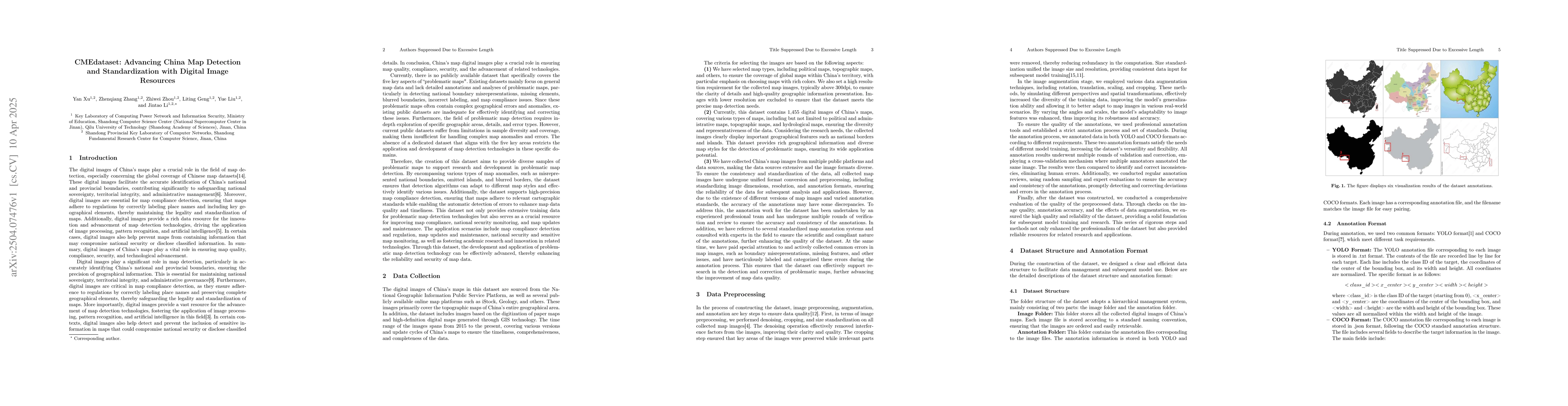
The paper describes the creation of the CMEdataset, a specialized dataset for problematic map detection in China, addressing issues like boundary misrepresentations, missing elements, and blurred boundaries. It details the data collection, standardization, augmentation techniques, and annotation process using professional tools and strict standards to ensure high-quality annotations in both YOLO and COCO formats.

Key Results

  • The CMEdataset provides diverse samples for problematic map detection technologies.
  • It supports high-precision map compliance detection and enhances map data quality and timeliness.

Significance

This dataset is crucial for map compliance, national security monitoring, and map updates, fostering innovation and application of related technologies by offering essential resources for these purposes.

Technical Contribution

The CMEdataset, along with its detailed structure and annotation formats in YOLO and COCO, serves as a valuable resource for model training and research in automated map data detection technology.

Novelty

The CMEdataset stands out by specifically addressing problematic map detection issues, providing annotated samples for complex boundary errors, omissions, and ambiguities, which are not adequately covered in existing datasets.

Limitations

  • The dataset's applicability might be limited to maps specific to China due to its focus on Chinese territorial integrity and sovereignty issues.
  • Performance in detecting very small-scale features or highly occluded objects may still pose challenges.

Future Work

  • Expanding the dataset's scale by incorporating more map types and regions to enhance its diversity and representativeness.
  • Improving data annotation quality and strengthening applicability in tasks involving complex backgrounds and small target detection.

Paper Details

PDF Preview

Download PDF

Key Terms

No key terms available for this paper.

Citation Network

Current paper (gray), citations (green), references (blue)

Current Paper
Citations
References
Click to view

No citations found for this paper.

Comments (0)

This website uses cookies to ensure you get the best experience. Learn more