Quick Summary:

This paper presents a computer vision-based framework for extracting geological lineaments from optical remote sensing data, combining edge detection and line extraction techniques. The framework uses dimensionality reduction and noise removal techniques to enhance lineaments, tested on Landsat 8 data in Western Australia, showing strong correlation with geological maps and manual photointerpretation.

Summary

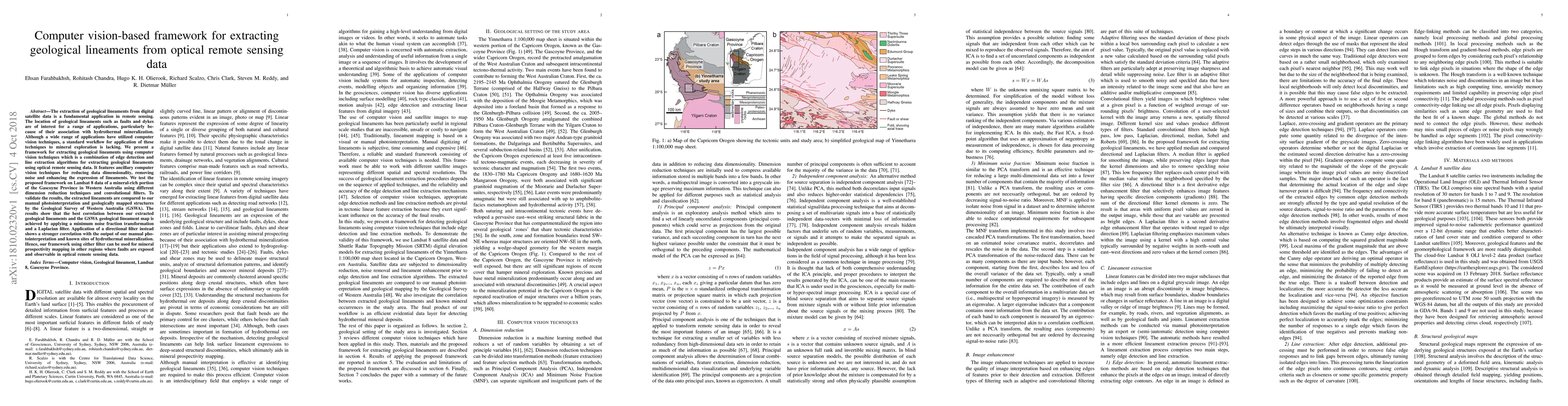
The extraction of geological lineaments from digital satellite data is a fundamental application in remote sensing. The location of geological lineaments such as faults and dykes are of interest for a range of applications, particularly because of their association with hydrothermal mineralization. Although a wide range of applications have utilized computer vision techniques, a standard workflow for application of these techniques to mineral exploration is lacking. We present a framework for extracting geological lineaments using computer vision techniques which is a combination of edge detection and line extraction algorithms for extracting geological lineaments using optical remote sensing data. It features ancillary computer vision techniques for reducing data dimensionality, removing noise and enhancing the expression of lineaments. We test the proposed framework on Landsat 8 data of a mineral-rich portion of the Gascoyne Province in Western Australia using different dimension reduction techniques and convolutional filters. To validate the results, the extracted lineaments are compared to our manual photointerpretation and geologically mapped structures by the Geological Survey of Western Australia (GSWA). The results show that the best correlation between our extracted geological lineaments and the GSWA geological lineament map is achieved by applying a minimum noise fraction transformation and a Laplacian filter. Application of a directional filter instead shows a stronger correlation with the output of our manual photointerpretation and known sites of hydrothermal mineralization. Hence, our framework using either filter can be used for mineral prospectivity mapping in other regions where faults are exposed and observable in optical remote sensing data.

AI Key Findings

Get AI-generated insights about this paper's methodology, results, and significance.

Paper Details

PDF Preview

Download PDF

Key Terms

remote sensing (0.253)
computer vision (0.223)
remote (0.217)
filter (0.209)
sensing (0.194)
vision (0.193)
manual (0.182)
techniques (0.181)
extracting (0.179)
computer (0.178)
extraction (0.156)
extracted (0.153)
application (0.142)
noise (0.124)
correlation (0.124)
framework (0.123)
optical (0.118)
data (0.115)
removing (0.113)
directional (0.113)

Citation Network

Current paper (gray), citations (green), references (blue)

Current Paper
Citations
References
Click to view
Title Authors Year Actions
Lineaments and hydrothermal alteration mapping in the Arkawit area, NE Sudan: insights from remote sensing
Talha Mohamed Yousif, O. K. Aromolaran, Khalid Mustafa Kheiralla
2025
View Paper
The intelligent fault identification method based on multi-source information fusion and deep learning
Dashu Guo, Xiaoshuang Yang, Peng Peng, Lei Zhu, Handong He
2025
View Paper
Fractures analysis in the Takelsa basin (northeastern Tunisia) using field data and automatic extraction for groundwater investigation
Sabra Dhouioui, H. Mzali, Kalthoum Hafsa
2024
View Paper
Curvilinear lineament extraction: Bayesian optimization of Principal Component Wavelet Analysis and Hysteresis Thresholding
Bahman Abbassi, Li-Zhen Cheng
2024
View Paper
A comparative analysis to assess the efficiency of lineament extraction utilizing satellite imagery from Landsat-8, Sentinel-2B, and Sentinel-1A: A case study around Suez Canal Zone, Egypt
Hadeer Ahmed Desoky, Mohamed Abd El-Dayem, M. Hegab
2024
View Paper
Geophysical insights into basement faults influencing basin evolution: A case study from Tennant Creek Block, North Australian Craton
Joel Kumwenda, Peter Betts, R. Armit
2024
View Paper
From beasts to bytes: Revolutionizing zoological research with artificial intelligence
Yu-Juan Zhang, Zeyu Luo, Yawen Sun, Junhao Liu, Zongqing Chen
2023
View Paper
A class-driven hierarchical ResNet for classification of multispectral remote sensing images
Giulio Weikmann, Gianmarco Perantoni, Lorenzo Bruzzone
2023
View Paper
Prospectivity modelling of critical mineral deposits using a generative adversarial network with oversampling and positive-unlabelled bagging
E. Farahbakhsh, Jack Maughan, R. D. Müller
2023
View Paper
Determination of groundwater potential zones on the eastern slope of Mount Cameroon using geospatial techniques and seismoelectric method
Lionel Junior Ngome Njumbe, A. D. Lordon, C. M. Agyingi
2023
View Paper
Application of data-driven multi-index overlay and BWM-MOORA MCDM methods in mineral prospectivity mapping of porphyry Cu mineralization
Shokouh Riahi, A. Bahroudi, M. Abedi, D. Lentz, S. Aslani
2023
View Paper
Integration of remote sensing and geophysical data for structural lineaments analysis in the Rag-e-Sefid oil/gas field and surrounding areas, SW Iran
Z. Riahi, K. Sarkarinejad, A. Faghih, B. Soleimany, Gholamreza Payrovian
2023
View Paper
A comparative analysis of multi-index overlay and fuzzy ordered weighted averaging methods for porphyry Cu prospectivity mapping using remote sensing data: the case study of Chahargonbad area, SE of Iran
Shokouh Riahi, A. Bahroudi, M. Abedi, S. Aslani
2022
View Paper
Seismo-Lineaments in Egypt: Analysis and Implications for Active Tectonic Structures and Earthquake Magnitudes
S. Moustafa, Mohamed S. Abdalzaher, H. E. Abdelhafiez
2022
View Paper
Lithology identification in carbonate thin section images of the Brazilian pre-salt reservoirs by the computational vision and deep learning
E. Faria, Juliana. M. Coelho, Thais F. Matos, Bernardo Santos, W. Trevizan, J. L. Gonzalez, C. Bom, M. P. de Albuquerque, M. P. de Albuquerque
2022
View Paper
Targeting local orogenic gold mineralisation zones using data-driven evidential belief functions: the Godarsorkh area, Central Iran
M. Maleki, S. Niroomand, S. Rajabpour, Amin Beiranvand Pour, Salahadin Ebrahimpour
2022
View Paper
GEOLOGICAL FEATURES IDENTIFIED FROM FIELD OBSERVATIONS AND REMOTE SENSING DATA ON THE UM TAGHIR AREA, EASTERN DESERT, EGYPT
H. Awad, I. A. El-Leil, M. Kamel, A. Tolba, A. Nastavkin, R. M. El-Wardany
2022
View Paper
Harnessing the Power of Machine Learning for Mapping of Iron Oxide Mineralization using Sentinel Satellite Spectral Imagery
Muhammad Ahsan Mahboob, B. Genc, Iqra Atif
2022
View Paper
Structural lineament mapping of Central-Eastern high atlas, Morocco, using ASAR/Envisat and SAR/sentinel 1B data
Ibtissame Bentahar, Mustapha Allouban, Mohammed Raji, Hicham Si Mhmadi, Noura Zoraa
2022
View Paper
Observing tectonic-geomorphological changes along the Dawki Fault and adjoining areas of Sylhet, Bangladesh from 1980 to 2020 using remote sensing and GIS techniques
B. Nath, N. Choudhury, A. K. Mitra
2022
View Paper
Assessment of radarsat-1, ALOS PALSAR and sentinel-1 SAR satellite images for geological lineament mapping
Mohcine Chakouri, Abderrazak El Harti, R. Lhissou, Jaouad El Hachimi, Amine Jellouli, Zakaria Adiri
2022
View Paper
Investigating groundwater recharge potential of Notwane catchment in Botswana using geophysical and geospatial tools
O. Tafila, R. T. Ranganai, D. Moalafhi, K. Moreri, J. Maphanyane
2022
View Paper
A Comparative Study of Convolutional Neural Networks and Conventional Machine Learning Models for Lithological Mapping Using Remote Sensing Data
Hojat Shirmard, E. Farahbakhsh, Elnaz Heidari, Amin Beiranvand Pour, B. Pradhan, Dietmar Müller, Rohitash Chandra
2022
View Paper
Geochemical and Hydrothermal Alteration Patterns of the Abrisham-Rud Porphyry Copper District, Semnan Province, Iran
T. Timkin, M. Abedini, M. Ziaii, M. Ghasemi
2022
View Paper
A Remote-Sensing-Based Alteration Zonation Model of the Duolong Porphyry Copper Ore District, Tibet
F. Yao, Xin Xu, Jianmin Yang, Xinxia Geng
2021
View Paper
Application of Gaofen-5 hyperspectral data in uranium exploration: a case study of Weijing in Inner Mongolia, China
Yuan-tao Zhang, W. Pan, Zhang-Fa Yu
2021
View Paper
Hydrothermal alteration and structural mapping of the Qolqoleh-Kasnazan shear zone in Iran using remote sensing data
M. Maleki, S. Niroomand, E. Farahbakhsh, S. Modabberi, H. Tajeddin
2021
View Paper
Predicting the emplacement of Cordilleran porphyry copper systems using a spatio-temporal machine learning model
J. Díaz-Rodríguez, R. Müller, Rohitash Chandra
2021
View Paper
Formation of the asymmetric pattern of a river lithological catchment basin in relation to specific features of the tectonic structure of the territory
Тatiana Trifonova, P. Shutov
2021
View Paper
Fault-Based Geological Lineaments Extraction Using Remote Sensing and GIS—A Review
Hemayatullah Ahmadi, E. Pekkan
2021
View Paper
Application of optical and radar satellite images for mapping tectonic lineaments in kerdous inlier of the Anti-Atlas belt, Morocco
Amine Jellouli, Abderrazak El Harti, Zakaria Adiri, Mohcine Chakouri, Jaouad El Hachimi, E. Bachaoui
2021
View Paper
A review of machine learning in processing remote sensing data for mineral exploration
Hodjat Shirmard, E. Farahbakhsh, R. Müller, Rohitash Chandra
2021
View Paper
GENERATIVE ADVERSARIAL NETWORKS AS A NOVEL APPROACH FOR TECTONIC FAULT AND FRACTURE EXTRACTION IN HIGH-RESOLUTION SATELLITE AND AIRBORNE OPTICAL IMAGES
B. Jafrasteh, I. Manighetti, J. Zerubia
2020
View Paper
Integration of Selective Dimensionality Reduction Techniques for Mineral Exploration Using ASTER Satellite Data
Hodjat Shirmard, E. Farahbakhsh, A. B. Pour, A. M. Muslim, R. Müller, Rohitash Chandra
2020
View Paper
3D Mineral Prospectivity Modeling for the Low-Sulfidation Epithermal Gold Deposit: A Case Study of the Axi Gold Deposit, Western Tianshan, NW China
Xiancheng Mao, Wei Zhang, Zhankun Liu, Jia Ren, Richard C. Bayless, Hao Deng
2020
View Paper
Three-dimensional weights of evidence modelling of a deep-seated porphyry Cu deposit
E. Farahbakhsh, A. Hezarkhani, Taymour Eslamkish, A. Bahroudi, Rohitash Chandra
2019
View Paper
Comparative analysis of SAR sensors for effective tectonic lineament mapping in semiarid region
Mohcine Chakouri, Amine Jellouli, Soufiane Hajaj, Jaouad El Hachimi, Abdelkarim Ouguinaz, Abdelhaq Aangri, Abderrazak El Harti
2025
View Paper
Identification of permeable zone in Kepahiang geothermal prospect area (Bengkulu) using integration of fault and fracture density method with gravity data
Fadhila Friany Putri, Y. Daud
2023
View Paper
Information System for Estimation Spatial Characteristics of Lineament Networks Derived from Satellite Images
V. Hnatushenko, O. Korobko, V. Lytvyn, Sergey Nikulin, K. Sergieieva
2022
View Paper
Geological map feature extraction using object detection techniques - a comparative analysis
P. A. N. Dilhan, R. Siyambalapitiya
2022
View Paper
Satellite Image Enhancement using Wavelet-domain based on Singular Value Decomposition
Muhammad Aamir, Ziaur Rahman, Yifei Pu, Waheed Ahmed, Kanza Gulzar
2019
View Paper

Comments (0)

This website uses cookies to ensure you get the best experience. Learn more