Conditional Denoising of Remote Sensing Imagery Using Cycle-Consistent Deep Generative Models

Source: ArXiv

AI Quick Summary

This paper explores the use of cycle-consistent deep generative models for denoising cloudy Sentinel-2 imagery, leveraging cloud-penetrating bands to improve environmental modelling and humanitarian operations. The Fréchet Distance metric is adapted to evaluate model performance, highlighting the potential and limitations of generative models in Earth science applications.

Share: Share on X LinkedIn

Summary

The potential of using remote sensing imagery for environmental modelling and for providing real time support to humanitarian operations such as hurricane relief efforts is well established. These applications are substantially affected by missing data due to non-structural noise such as clouds, shadows and other atmospheric effects. In this work we probe the potential of applying a cycle-consistent latent variable deep generative model (DGM) for denoising cloudy Sentinel-2 observations conditioned on the information in cloud penetrating bands. We adapt the recently proposed Fr\'{e}chet Distance metric to remote sensing images for evaluating performance of the generator, demonstrate the potential of DGMs for conditional denoising, and discuss future directions as well as the limitations of DGMs in Earth science and humanitarian applications.

AI Key Findings

Generated Sep 02, 2025

Methodology

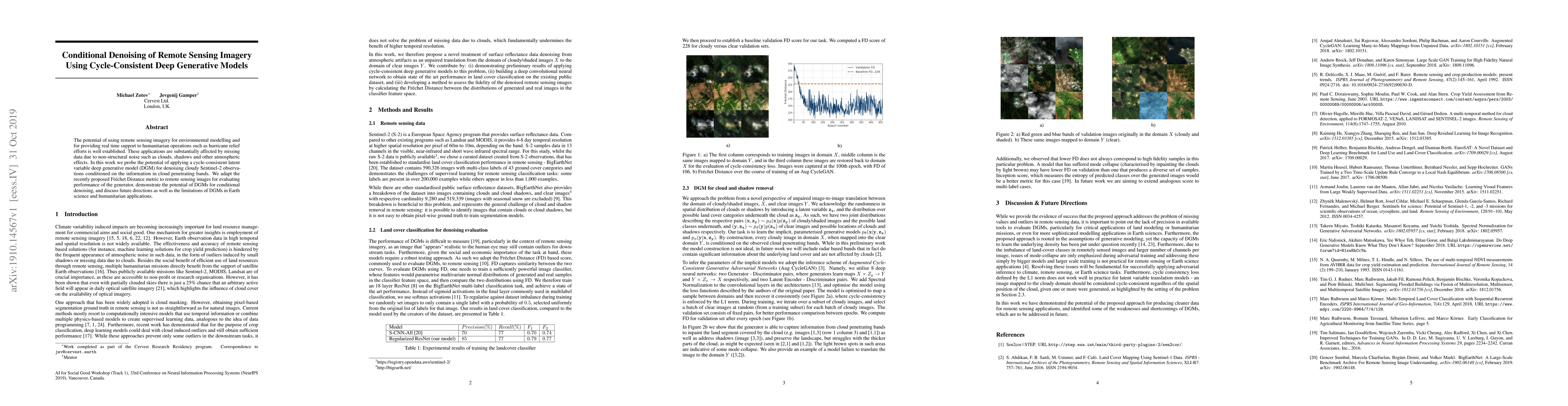
The paper proposes a novel approach using cycle-consistent deep generative models (DGMs) for denoising cloudy Sentinel-2 remote sensing imagery. It conditions the denoising process on cloud-penetrating bands and employs an Augmented CycleGAN architecture with spectral normalization. The performance is evaluated using the Fréchet Distance (FD) metric between the distribution of generated and real images in a classifier feature space.

Key Results

  • Preliminary results demonstrate the potential of DGMs for conditional denoising of remote sensing imagery.
  • A deep convolutional neural network (ResNet) achieves state-of-the-art performance in land cover classification on the BigEarthNet dataset.

Significance

This research is significant for environmental modeling and humanitarian operations, such as hurricane relief efforts, which are affected by missing data due to non-structural noise like clouds, shadows, and atmospheric effects.

Technical Contribution

The paper introduces a method for unpaired image-to-image translation between cloudy/shaded and clear image domains, using latent variables to account for randomness in cloud/shadow spatial distribution.

Novelty

The approach differs from existing methods by treating the denoising problem as an unpaired translation task and conditioning on cloud-penetrating bands, while also proposing a robust evaluation method using the Fréchet Distance.

Limitations

  • The lack of precision in available tools to evaluate DGMs, particularly for critical applications of land modeling or humanitarian missions.
  • The capacity of DGMs to learn the underlying density has been questioned recently.

Future Work

  • Addressing issues of mode collapse and improving cycle-consistency for latent variable translation models.
  • Extending analogous scores to multi-label cases for evaluating DGMs.

Paper Details

PDF Preview

Download PDF

Key Terms

remote sensing (0.282)
denoising (0.264)
remote (0.242)
sensing (0.216)
potential (0.173)
applications (0.146)
conditioned (0.146)
atmospheric (0.146)

Citation Network

Current paper (gray), citations (green), references (blue)

Display is limited for performance on very large graphs.

Current Paper
Citations
References
Click to view
Title Authors Year Actions

Comments (0)

This website uses cookies to ensure you get the best experience. Learn more