Contextual Pyramid Attention Network for Building Segmentation in Aerial Imagery
Publication
Metrics
AI Quick Summary
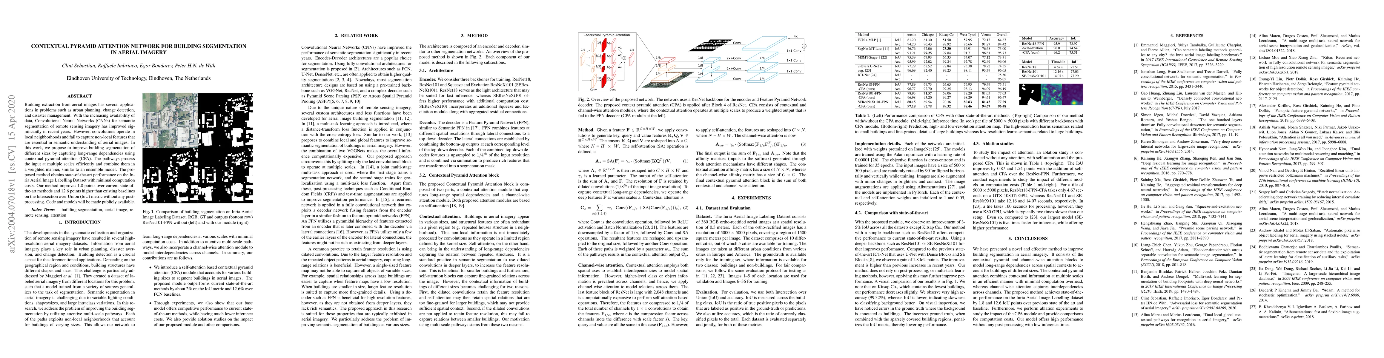
This paper proposes a Contextual Pyramid Attention Network (CPA) to enhance building segmentation in aerial imagery, achieving state-of-the-art results by capturing long-range dependencies and improving Intersection over Union (IoU) scores significantly over existing methods. The method processes input at multiple scales and combines them efficiently.
Paper Preview
Abstract
Building extraction from aerial images has several applications in problems such as urban planning, change detection, and disaster management. With the increasing availability of data, Convolutional Neural Networks (CNNs) for semantic segmentation of remote sensing imagery has improved significantly in recent years. However, convolutions operate in local neighborhoods and fail to capture non-local features that are essential in semantic understanding of aerial images. In this work, we propose to improve building segmentation of different sizes by capturing long-range dependencies using contextual pyramid attention (CPA). The pathways process the input at multiple scales efficiently and combine them in a weighted manner, similar to an ensemble model. The proposed method obtains state-of-the-art performance on the Inria Aerial Image Labelling Dataset with minimal computation costs. Our method improves 1.8 points over current state-of-the-art methods and 12.6 points higher than existing baselines on the Intersection over Union (IoU) metric without any post-processing. Code and models will be made publicly available.
AI Key Findings
Get AI-generated insights about this paper's methodology, results, significance, and more — seven facets brought into focus.
Impact
Paper Details
Authors
PDF Preview
Key Terms
Citation Network
Current paper (gray), citations (green), references (blue)
Display is limited for performance on very large graphs.
Discussion 0