Cost-effective Land Cover Classification for Remote Sensing Images
Publication
Metrics
AI Quick Summary
This paper proposes a cost-effective framework for remote sensing land cover classification by leveraging cloud computing to minimize unnecessary computational efforts. The method allows clustering algorithms to terminate early when sufficient accuracy (85%-99.9%) is achieved, significantly reducing cloud computation costs.
Paper Preview
Abstract
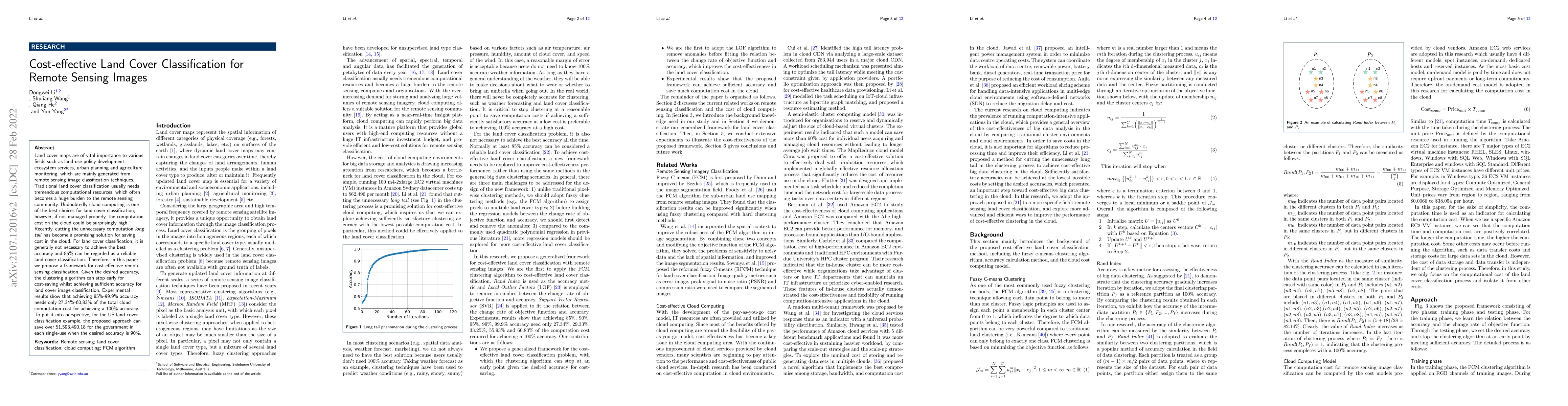
Land cover maps are of vital importance to various fields such as land use policy development, ecosystem services, urban planning and agriculture monitoring, which are mainly generated from remote sensing image classification techniques. Traditional land cover classification usually needs tremendous computational resources, which often becomes a huge burden to the remote sensing community. Undoubtedly cloud computing is one of the best choices for land cover classification, however, if not managed properly, the computation cost on the cloud could be surprisingly high. Recently, cutting the unnecessary computation long tail has become a promising solution for saving the cost in the cloud. For land cover classification, it is generally not necessary to achieve the best accuracy and 85% can be regarded as a reliable land cover classification. Therefore, in this paper, we propose a framework for cost-effective remote sensing classification. Given the desired accuracy, the clustering algorithm can stop early for cost-saving whilst achieving sufficient accuracy for land cover image classification. Experimental results show that achieving 85%-99.9% accuracy needs only 27.34%-60.83% of the total cloud computation cost for achieving a 100% accuracy. To put it into perspective, for the US land cover classification example, the proposed approach can save over $1,593,490.18 for the government in each single-use when the desired accuracy is 90%.
AI Key Findings
Get AI-generated insights about this paper's methodology, results, significance, and more — seven facets brought into focus.
Impact
Paper Details
Authors
PDF Preview
Key Terms
Citation Network
Current paper (gray), citations (green), references (blue)
Display is limited for performance on very large graphs.
Discussion 0