Crop mapping in the small sample/no sample case: an approach using a two-level cascade classifier and integrating domain knowledge
Publication
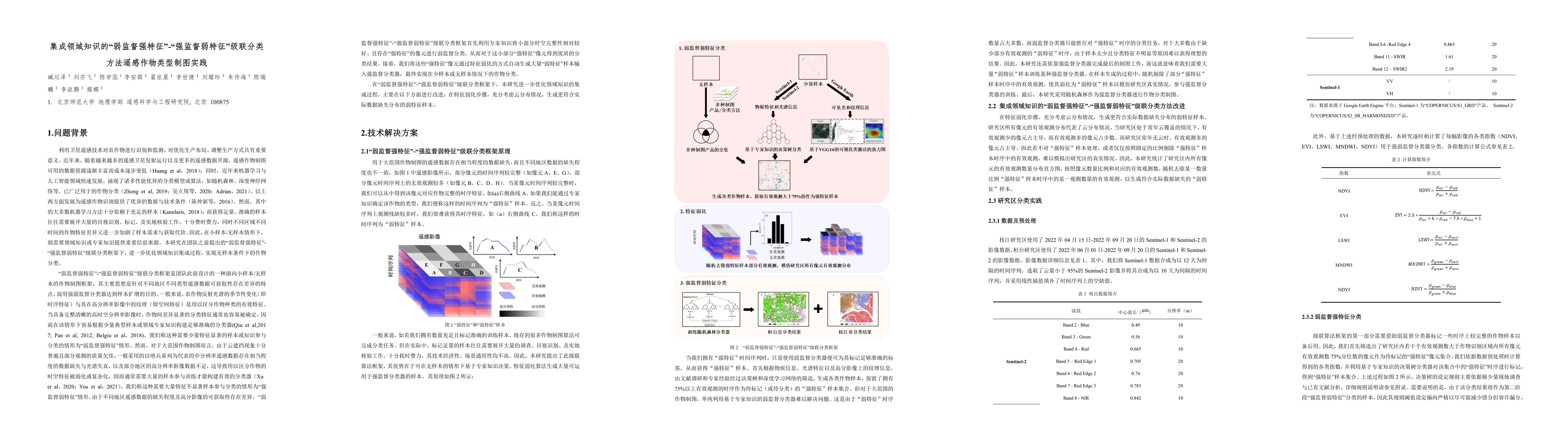
Metrics
AI Quick Summary
This paper proposes a crop mapping method using a two-level cascade classifier that integrates domain knowledge to address the challenge of small sample sizes. It combines a weak classifier with strong features and a strong classifier trained on augmented samples, achieving an 82% accuracy in a 2021 competition.
Paper Preview
Abstract
Mapping crops using remote sensing technology is important for food security and land management. Machine learning-based methods has become a popular approach for crop mapping in recent years. However, the key to machine learning, acquiring ample and accurate samples, is usually time-consuming and laborious. To solve this problem, a crop mapping method in the small sample/no sample case that integrating domain knowledge and using a cascaded classification framework that combine a weak classifier learned from samples with strong features and a strong classifier trained by samples with weak feature was proposed. First, based on the domain knowledge of various crops, a low-capacity classifier such as decision tree was applied to acquire those pixels with distinctive features and complete observation sequences as "strong feature" samples. Then, to improve the representativeness of these samples, sample augmentation strategy that artificially remove the observations of "strong feature" samples according to the average valid observation proportion in target area was applied. Finally, based on the original samples and augmented samples, a large-capacity classifier such as random forest was trained for crop mapping. The method achieved an overall accuracy of 82% in the MAP crop recognition competition held by Syngenta Group, China in 2021 (third prize, ranked fourth). This method integrates domain knowledge to overcome the difficulties of sample acquisition, providing a convenient, fast and accurate solution for crop mapping.
AI Key Findings
Get AI-generated insights about this paper's methodology, results, significance, and more — seven facets brought into focus.
Impact
Paper Details
Authors
PDF Preview
Key Terms
Citation Network
Current paper (gray), citations (green), references (blue)
Display is limited for performance on very large graphs.
Discussion 0