Mapping agriculture in tropical areas through remote sensing presents unique challenges, including the lack of high-quality annotated data, the elevated costs of labeling, data variability, and regional generalisation. This paper advocates a Data-Centric Artificial Intelligence (DCAI) perspective and pipeline, emphasizing data quality and curation as key drivers for model robustness and scalability. It reviews and prioritizes techniques such as confident learning, core-set selection, data augmentation, and active learning. 
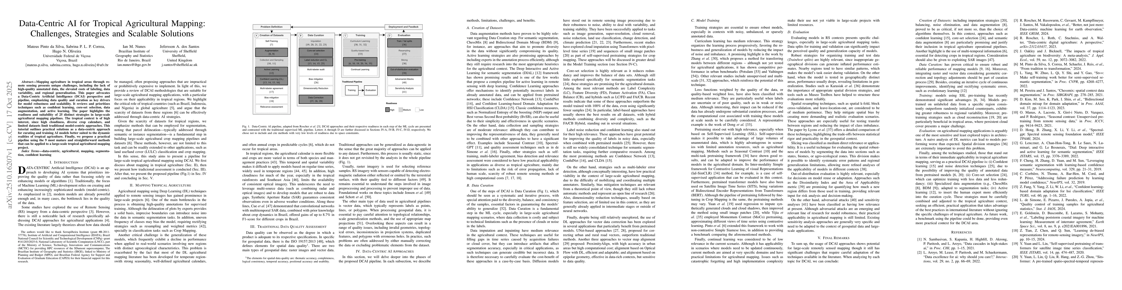
The paper highlights the readiness and suitability of 25 distinct strategies in large-scale agricultural mapping pipelines. The tropical context is of high interest, since high cloudiness, diverse crop calendars, and limited datasets limit traditional model-centric approaches. This tutorial outlines practical solutions as a data-centric approach for curating and training AI models better suited to the dynamic realities of tropical agriculture. Finally, we propose a practical pipeline using the 9 most mature and straightforward methods that can be applied to a large-scale tropical agricultural mapping project.
Generated Oct 29, 2025
The research employs a data-centric approach to address challenges in tropical agriculture mapping, combining techniques like confident learning, core-set selection, and multi-temporal data augmentation. It integrates remote sensing data with geospatial vector data, emphasizing iterative curation and pre-training strategies for robustness.
This research provides practical frameworks for reliable agricultural mapping in data-scarce tropical regions, enhancing the robustness of AI models against environmental variability and improving decision-making for sustainable land management.
The paper introduces a comprehensive DCAI pipeline combining confident learning, core-set selection, and specialized data augmentation techniques tailored for tropical agriculture applications.
This work uniquely addresses tropical agriculture challenges through a data-centric lens, integrating multi-temporal remote sensing with geospatial vector data and emphasizing iterative curation processes for improved model reliability.
Fan Yang, Xia Hu, Zaid Pervaiz Bhat et al.
Wei Xiang, Tiehua Zhang, Jiong Jin et al.
Xuming Hu, Weijia Li, Conghui He et al.
Rifat Ara Shams, Didar Zowghi, Muneera Bano
Comments (0)