Publication

Published: Feb 14, 2025
Categories: cs.CV, cs.LG, I.4.9

Metrics

Source: ArXiv

Quick Actions

View PDF

AI Quick Summary

This research investigates the use of data-driven super-resolution techniques to enhance low-resolution Water Fraction Maps (WFM) into high-resolution Flood Inundation Maps (FIM), leveraging synthetic data from physics-based simulations to train deep learning models. The study demonstrates improved accuracy over traditional methods and successful zero-shot performance in regions with similar hydroclimatological conditions.

Quick Answers

What is "Data-driven Super-Resolution of Flood Inundation Maps using Synthetic Simulations" about?

This research investigates the use of data-driven super-resolution techniques to enhance low-resolution Water Fraction Maps (WFM) into high-resolution Flood Inundation Maps (FIM), leveraging synthetic data from physics-based simulations to train deep learning models. The study demonstrates improved accuracy over traditional methods and successful zero-shot performance in regions with similar hydroclimatological conditions.

What methodology did the authors use?

The research employs a data-driven super-resolution framework using deep learning models to convert Water Fraction Maps (WFMs) into high-resolution Flood Inundation Maps (FIMs). Synthetic data generated through physics-based simulations is used to overcome data scarcity, with models trained on Iowa datasets and evaluated on five regions including three hydro-climatically similar and two dissimilar regions. More in Methodology →

What are the key results?

Data-driven models outperform traditional interpolation techniques for similar hydro-climatic regions. — Synthetic data can serve as a stand-in for real-world data in training such data-intensive models. More in Key Results →

Why is this work significant?

This research is crucial for studying flood inundation dynamics in real-time emergency response applications. It proposes three machine learning models to produce FIMs, enhancing the understanding and monitoring of flood events globally. More in Significance →

What are the main limitations?

The study focuses solely on riverine flooding and does not address pluvial or coastal inundation, which is left for future work. — Performance evaluation is limited to specific regions with varying degrees of similarity to the training data. More in Limitations →

Paper Preview

Abstract

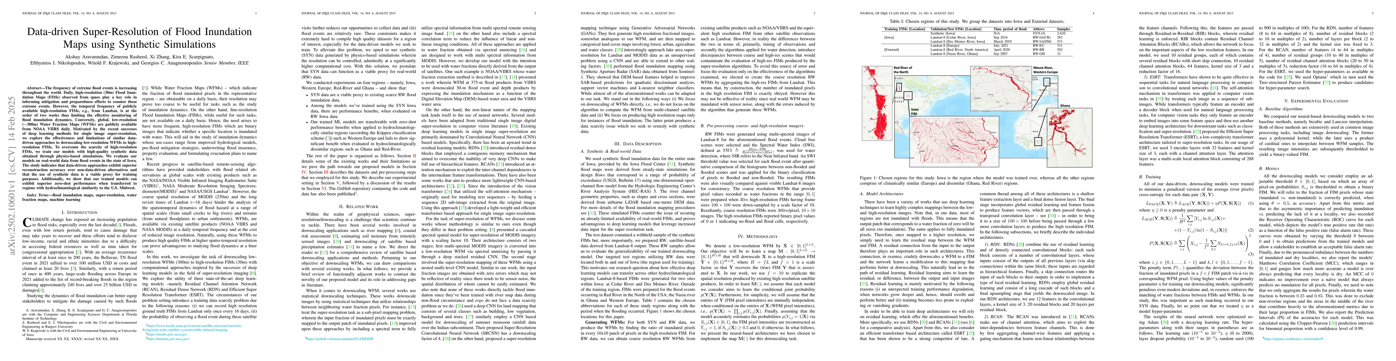
The frequency of extreme flood events is increasing throughout the world. Daily, high-resolution (30m) Flood Inundation Maps (FIM) observed from space play a key role in informing mitigation and preparedness efforts to counter these extreme events. However, the temporal frequency of publicly available high-resolution FIMs, e.g., from Landsat, is at the order of two weeks thus limiting the effective monitoring of flood inundation dynamics. Conversely, global, low-resolution (~300m) Water Fraction Maps (WFM) are publicly available from NOAA VIIRS daily. Motivated by the recent successes of deep learning methods for single image super-resolution, we explore the effectiveness and limitations of similar data-driven approaches to downscaling low-resolution WFMs to high-resolution FIMs. To overcome the scarcity of high-resolution FIMs, we train our models with high-quality synthetic data obtained through physics-based simulations. We evaluate our models on real-world data from flood events in the state of Iowa. The study indicates that data-driven approaches exhibit superior reconstruction accuracy over non-data-driven alternatives and that the use of synthetic data is a viable proxy for training purposes. Additionally, we show that our trained models can exhibit superior zero-shot performance when transferred to regions with hydroclimatological similarity to the U.S. Midwest.

AI Key Findings

Generated Jun 11, 2025

Methodology — What approach did the authors take?

The research employs a data-driven super-resolution framework using deep learning models to convert Water Fraction Maps (WFMs) into high-resolution Flood Inundation Maps (FIMs). Synthetic data generated through physics-based simulations is used to overcome data scarcity, with models trained on Iowa datasets and evaluated on five regions including three hydro-climatically similar and two dissimilar regions.

Key Results — What are the main findings?

  • Data-driven models outperform traditional interpolation techniques for similar hydro-climatic regions.
  • Synthetic data can serve as a stand-in for real-world data in training such data-intensive models.
  • Transferability of models is evident for hydro-climatically similar regions but less so for dissimilar regions like Ghana and Red River.
  • Models show superior recognition of underlying stream network geometry compared to classical methods, though they struggle with narrow river streams and localized high-elevation features.
  • The study suggests that good quality synthetic data can be useful surrogates for downscaling low-resolution WFMs to high-resolution FIMs, especially in regions where real-world data is scarce.

Significance — Why does this research matter?

This research is crucial for studying flood inundation dynamics in real-time emergency response applications. It proposes three machine learning models to produce FIMs, enhancing the understanding and monitoring of flood events globally.

Technical Contribution — What is the technical contribution?

The paper presents a novel framework combining deep learning models with synthetic data generated from physics-based simulations for super-resolution of WFMs into FIMs, addressing the scarcity of high-resolution FIMs for flood monitoring.

Novelty — What is new about this work?

The research distinguishes itself by utilizing synthetic data for training, demonstrating the viability of data-driven approaches over classical techniques for downscaling, and highlighting the transferability of these models to similar hydro-climatic regions.

Limitations — What are the limitations of this study?

  • The study focuses solely on riverine flooding and does not address pluvial or coastal inundation, which is left for future work.
  • Performance evaluation is limited to specific regions with varying degrees of similarity to the training data.
  • The methodology does not account for topographic features like Digital Elevation Models (DEMs) that could potentially improve downscaling performance.

Future Work — What did the authors propose for future work?

  • Extend the methodology to include pluvial and coastal inundation for a comprehensive flood monitoring system.
  • Incorporate topographic features such as DEMs to enhance downscaling performance.
  • Investigate the integration of this approach with daily available coarse-resolution optical data and high-resolution SAR-based FIMs from Sentinel for global-scale flood monitoring.

Paper Details

Paper ID: 2502.10601
Comments: 12 pages, 6 figures, 2 tables
Categories:
cs.CV cs.LG I.4.9

How to Cite This Paper

BibTeX
@article{aravamudan2025data,
  title         = {Data-driven Super-Resolution of Flood Inundation Maps using Synthetic
  Simulations},
  author        = {Aravamudan, Akshay and Nikolopoulos, Efthymios I. and Anagnostopoulos, Georgios C. and others},
  year          = {2025},
  eprint        = {2502.10601},
  archivePrefix = {arXiv},
  primaryClass  = {cs.CV},
}
APA 7
Aravamudan, A., Nikolopoulos, E., Anagnostopoulos, G., Scarpignato, K., Krajewski, W., Zhang, X., & Rasheed, Z. (2025). Data-driven Super-Resolution of Flood Inundation Maps using Synthetic
  Simulations. arXiv. https://arxiv.org/abs/2502.10601
MLA 9
Aravamudan, Akshay, et al. "Data-driven Super-Resolution of Flood Inundation Maps using Synthetic
  Simulations." arXiv, 2025, arxiv.org/abs/2502.10601.

No citations found for this paper.

Comments (0)

This website uses cookies to ensure you get the best experience. Learn more