DDOS: The Drone Depth and Obstacle Segmentation Dataset

Source: ArXiv

AI Quick Summary

The paper introduces a new synthetic dataset, DDOS, for depth and obstacle segmentation in aerial views, addressing the lack of annotated real-world drone datasets and providing tools for training robust models, especially for thin object detection. The dataset employs photo-realistic rendering and includes new drone-specific metrics for depth accuracy.

Share: Share on X LinkedIn

Summary

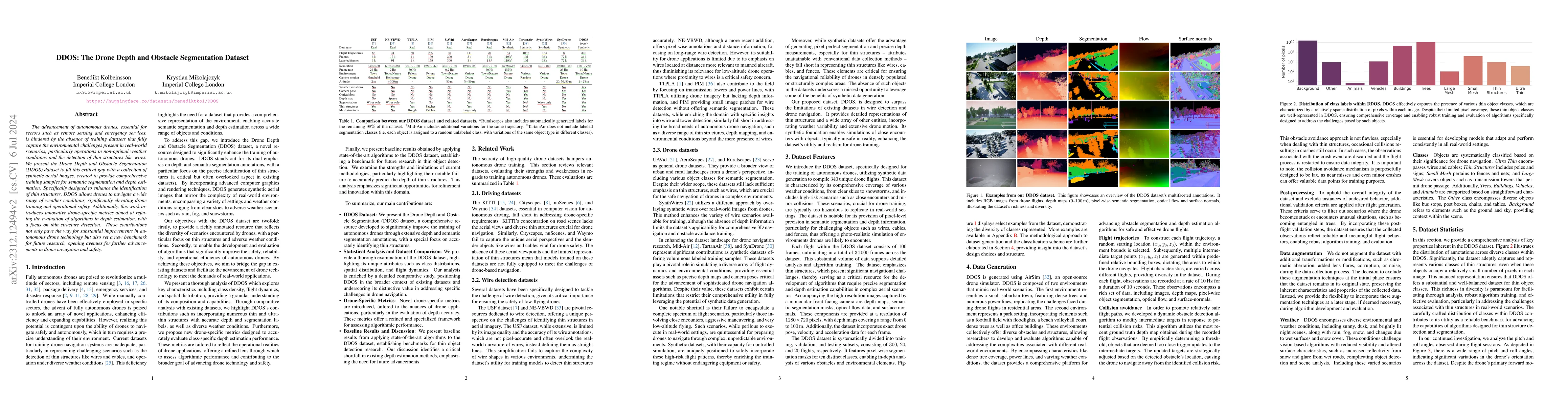
Accurate depth and semantic segmentation are crucial for various computer vision tasks. However, the scarcity of annotated real-world aerial datasets poses a significant challenge for training and evaluating robust models. Additionally, the detection and segmentation of thin objects, such as wires, cables, and fences, present a critical concern for ensuring the safe operation of drones. To address these limitations, we present a novel synthetic dataset specifically designed for depth and semantic segmentation tasks in aerial views. Leveraging photo-realistic rendering techniques, our dataset provides a valuable resource for training models using a synthetic-supervision training scheme while introducing new drone-specific metrics for depth accuracy.

AI Key Findings

Generated Sep 02, 2025

Methodology

The paper presents DDOS, a synthetic dataset for depth and semantic segmentation tasks in aerial views, using photo-realistic rendering techniques to address the scarcity of annotated real-world aerial datasets.

Key Results

  • DDOS effectively captures the presence of various thin object classes (wires, cables, fences) with a relatively sparse distribution of pixels in each image.
  • The dataset includes diverse environmental and weather conditions, such as sunny, dusk, night scenes, rain, fog, snow, and wet surfaces, challenging vision-based algorithms with reduced visibility and altered surface characteristics.
  • Novel drone-specific depth metrics are proposed, focusing on absolute relative depth estimation for distinct classes, especially for intricate structures like wires and cables.

Significance

This research is significant as it provides a valuable resource for training models using synthetic-supervision, addressing the limitations of scarce annotated real-world aerial datasets, and ensuring the safe operation of drones by focusing on thin object detection and segmentation.

Technical Contribution

The main technical contribution is the creation of DDOS, a synthetic aerial dataset with photo-realistic rendering, and the introduction of novel drone-specific depth metrics tailored for thin structure detection and segmentation.

Novelty

DDOS stands out by addressing the shortage of annotated real-world aerial datasets through a synthetic dataset, and by proposing new depth metrics specifically designed for drone applications, focusing on thin structures like wires and cables.

Limitations

  • The dataset is synthetic and does not contain real-world data, which may limit its applicability in certain scenarios.
  • The absence of augmentation techniques during data collection might restrict the dataset's exposure to additional real-world variations.

Future Work

  • Further research could focus on incorporating real-world data to complement the synthetic dataset and enhance its applicability.
  • Exploring additional augmentation techniques to increase the dataset's diversity and robustness.

Paper Details

PDF Preview

Download PDF

Key Terms

semantic segmentation (0.259)
aerial (0.256)
segmentation (0.255)
depth (0.235)
semantic (0.197)
synthetic (0.190)
training (0.188)
dataset (0.161)

Citation Network

Current paper (gray), citations (green), references (blue)

Display is limited for performance on very large graphs.

Current Paper
Citations
References
Click to view
Title Authors Year Actions

Comments (0)

This website uses cookies to ensure you get the best experience. Learn more