Authors
Publication
Metrics
Quick Actions
Quick Answers
What methodology did the authors use?
The study employs a combination of statistical analysis and computational modeling to examine urban segregation patterns using census data and agent-based simulations. More in Methodology →
What are the key results?
Significant income and racial segregation patterns persist across U.S. cities despite policy interventions — Neighborhood choice is influenced by both individual preferences and structural constraints More in Key Results →
Why is this work significant?
This research provides critical insights into the mechanisms driving urban segregation, informing equitable urban planning and policy development. More in Significance →
What are the main limitations?
Data quality issues in census reporting affect analysis accuracy — Model simplifications may overlook complex social dynamics More in Limitations →
Abstract
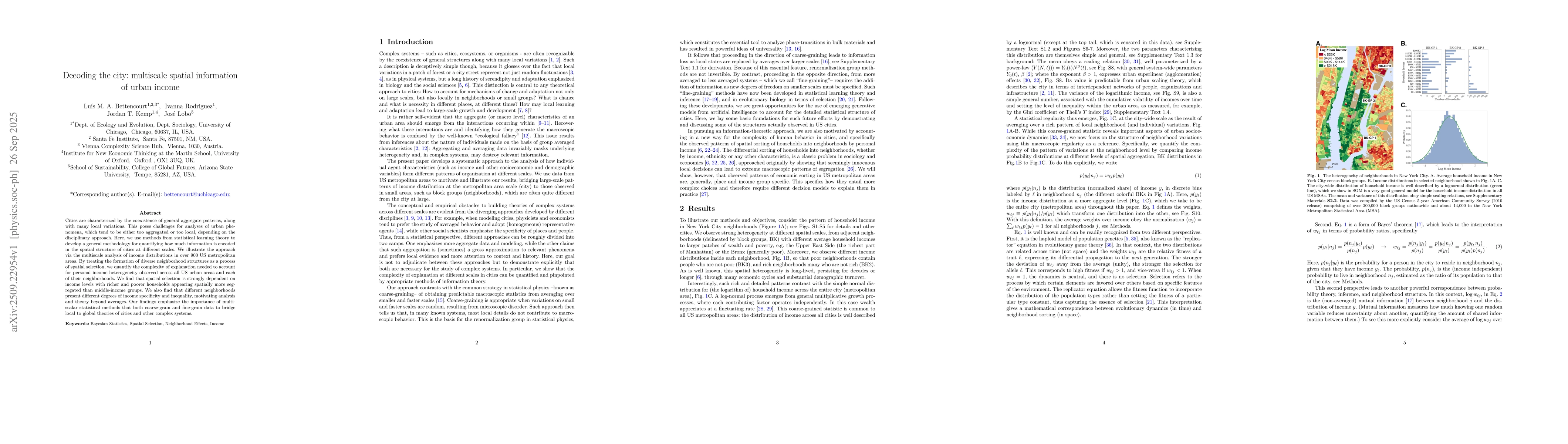
Cities are characterized by the coexistence of general aggregate patterns, along with many local variations. This poses challenges for analyses of urban phenomena, which tend to be either too aggregated or too local, depending on the disciplinary approach. Here, we use methods from statistical learning theory to develop a general methodology for quantifying how much information is encoded in the spatial structure of cities at different scales. We illustrate the approach via the multiscale analysis of income distributions in over 900 US metropolitan areas. By treating the formation of diverse neighborhood structures as a process of spatial selection, we quantify the complexity of explanation needed to account for personal income heterogeneity observed across all US urban areas and each of their neighborhoods. We find that spatial selection is strongly dependent on income levels with richer and poorer households appearing spatially more segregated than middle-income groups. We also find that different neighborhoods present different degrees of income specificity and inequality, motivating analysis and theory beyond averages. Our findings emphasize the importance of multiscalar statistical methods that both coarse-grain and fine-grain data to bridge local to global theories of cities and other complex systems.
AI Key Findings
Generated Oct 01, 2025
Methodology — What approach did the authors take?
The study employs a combination of statistical analysis and computational modeling to examine urban segregation patterns using census data and agent-based simulations.
Key Results — What are the main findings?
- Significant income and racial segregation patterns persist across U.S. cities despite policy interventions
- Neighborhood choice is influenced by both individual preferences and structural constraints
- Income inequality correlates strongly with spatial segregation metrics
Significance — Why does this research matter?
This research provides critical insights into the mechanisms driving urban segregation, informing equitable urban planning and policy development.
Technical Contribution — What is the technical contribution?
Development of a novel framework combining information theory with spatial analysis to quantify segregation dynamics
Novelty — What is new about this work?
First application of information-theoretic measures to analyze urban segregation patterns, offering new analytical perspectives
Limitations — What are the limitations of this study?
- Data quality issues in census reporting affect analysis accuracy
- Model simplifications may overlook complex social dynamics
Future Work — What did the authors propose for future work?
- Integrate longitudinal data to track segregation trends over time
- Explore the role of housing policies in segregation dynamics
- Investigate the impact of digital technologies on neighborhood formation
Paper Details
How to Cite This Paper
@article{rodriguez2025decoding,
title = {Decoding the city: multiscale spatial information of urban income},
author = {Rodriguez, Ivanna and Kemp, Jordan T. and Lobo, José and others},
year = {2025},
eprint = {2509.22954},
archivePrefix = {arXiv},
primaryClass = {physics.soc-ph},
}
Rodriguez, I., Kemp, J., Lobo, J., & Bettencourt, L. (2025). Decoding the city: multiscale spatial information of urban income. arXiv. https://arxiv.org/abs/2509.22954
Rodriguez, Ivanna, et al. "Decoding the city: multiscale spatial information of urban income." arXiv, 2025, arxiv.org/abs/2509.22954.
PDF Preview
Similar Papers
Found 4 papersSpatial Selection and the Multiscale Dynamics of Urban Change
Jordan T Kemp, Laura Fürsich, Luís M A Bettencourt
Using city-bike stopovers to reveal spatial patterns of urban attractiveness
Krystian Banet, Rafal Kucharski, Vitalii Naumov
Spatial Information and the Legibility of Urban Form: Big Data in Urban Morphology
Geoff Boeing
Quantifying the overall characteristics of urban mobility considering spatial information
Pengjun Zhao, Hao Wang, Xiao-Yong Yan
Comments (0)