01
MethodologyHow they did it
A Deep Geospatial Interpolation Network (DGIN) is proposed to interpolate missing information in spatial-temporal gaps.
This paper proposes a Deep Geospatial Interpolation Network (DGIN) to improve spatial-temporal interpolation, outperforming traditional methods like Kriging with lower mean squared error and execution time. The DGIN model uses spatial and sequential modules along with an attention block to effectively capture spatial and temporal dependencies.
A Deep Geospatial Interpolation Network (DGIN) is proposed to interpolate missing information in spatial-temporal gaps. More in Methodology →
DGIN achieves better results than alternative approaches for interpolating missing data in spatial-temporal gaps. — The model takes significantly less computation time compared to existing methods like Kriging and STNN. More in Key Results →
This research is important as it addresses a critical need for accurate spatial-temporal interpolation, which has significant implications for various fields such as climate modeling, urban planning, and emergency response. More in Significance →
The model may not perform well if historical and future information do not correlate with the spatial-temporal gaps. — The dataset used in this study is limited to two regions, and further research is needed to generalize the results. More in Limitations →
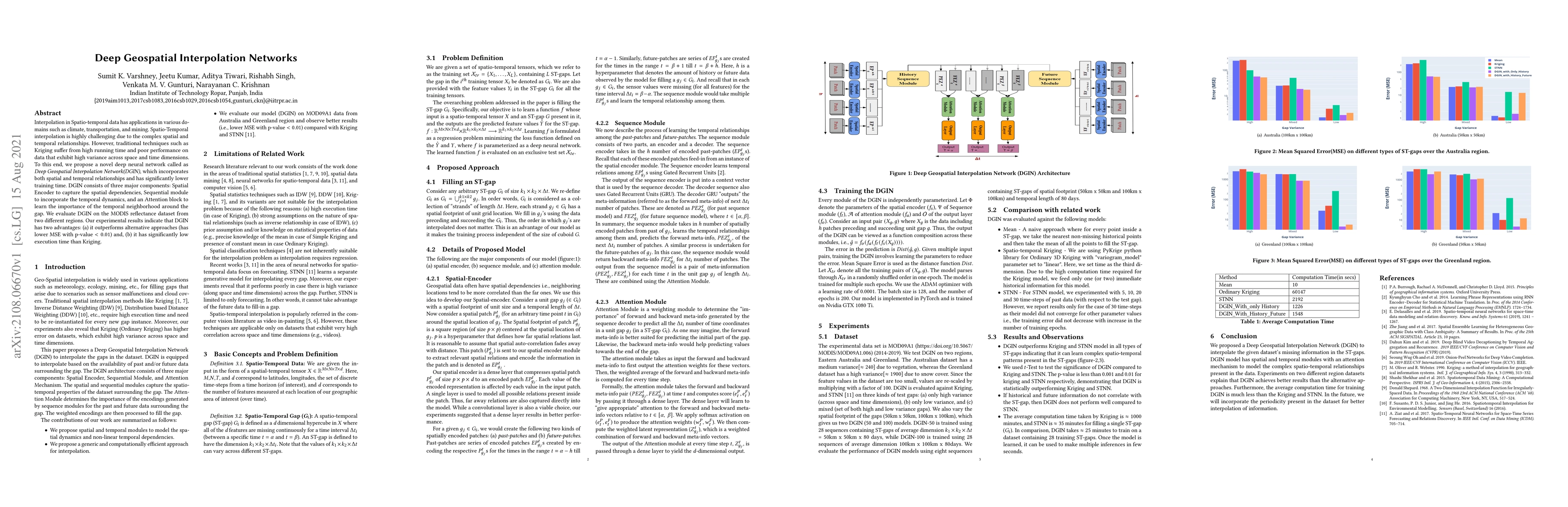
Interpolation in Spatio-temporal data has applications in various domains such as climate, transportation, and mining. Spatio-Temporal interpolation is highly challenging due to the complex spatial and temporal relationships. However, traditional techniques such as Kriging suffer from high running time and poor performance on data that exhibit high variance across space and time dimensions. To this end, we propose a novel deep neural network called as Deep Geospatial Interpolation Network(DGIN), which incorporates both spatial and temporal relationships and has significantly lower training time. DGIN consists of three major components: Spatial Encoder to capture the spatial dependencies, Sequential module to incorporate the temporal dynamics, and an Attention block to learn the importance of the temporal neighborhood around the gap. We evaluate DGIN on the MODIS reflectance dataset from two different regions. Our experimental results indicate that DGIN has two advantages: (a) it outperforms alternative approaches (has lower MSE with p-value < 0.01) and, (b) it has significantly low execution time than Kriging.
Seven facets of this paper, analysed and brought into focus by AI.
This research is important as it addresses a critical need for accurate spatial-temporal interpolation, which has significant implications for various fields such as climate modeling, urban planning, and emergency response.
A Deep Geospatial Interpolation Network (DGIN) is proposed to interpolate missing information in spatial-temporal gaps.
This research is important as it addresses a critical need for accurate spatial-temporal interpolation, which has significant implications for various fields such as climate modeling, urban planning, and emergency response.
The proposed DGIN model integrates spatial and temporal modules with an attention mechanism, enabling effective modeling of complex spatio-temporal relationships.
DGIN's use of a deep neural network architecture and attention mechanism provides a novel approach to spatial-temporal interpolation, distinguishing it from existing methods.
Current paper (gray), citations (green), references (blue)
Display is limited for performance on very large graphs.
Discussion 0