The study employs a Siamese U-Net architecture combined with the AlphaEarth dataset to detect burned areas using bi-temporal satellite imagery. The model processes pre- and post-fire images through shared convolutional weights to extract temporal changes, utilizing feature differencing in the decoder for precise boundary detection.
Deep Learning-Based Burned Area Mapping Using Bi-Temporal Siamese Networks and AlphaEarth Foundation Datasets
Publication
Metrics
Quick Answers
What methodology did the authors use?
The study employs a Siamese U-Net architecture combined with the AlphaEarth dataset to detect burned areas using bi-temporal satellite imagery. The model processes pre- and post-fire images through shared convolutional weights to extract temporal changes, utilizing feature differencing in the decoder for precise boundary detection. More in Methodology →
What are the key results?
The model achieved an overall accuracy of 95%, IoU of 0.6, and F1-score of 74% on the test dataset. — It successfully identifies burned areas across diverse ecosystems, particularly excelling in detecting partially burned vegetation and fire boundaries. More in Key Results →
Why is this work significant?
This research advances automated fire damage assessment and provides a scalable solution for global burned area monitoring, leveraging the AlphaEarth dataset for improved accuracy and efficiency in environmental monitoring and disaster management. More in Significance →
What are the main limitations?
False alarms persist in agricultural regions due to spectral similarities with crop cycles. — Challenges in detecting fragmented burn patterns and gradual severity transitions due to binary classification limitations. More in Limitations →
Abstract
Accurate and timely mapping of burned areas is crucial for environmental monitoring, disaster management, and assessment of climate change. This study presents a novel approach to automated burned area mapping using the AlphaEArth dataset combined with the Siamese U-Net deep learning architecture. The AlphaEArth Dataset, comprising high-resolution optical and thermal infrared imagery with comprehensive ground-truth annotations, provides an unprecedented resource for training robust burned area detection models. We trained our model with the Monitoring Trends in Burn Severity (MTBS) dataset in the contiguous US 
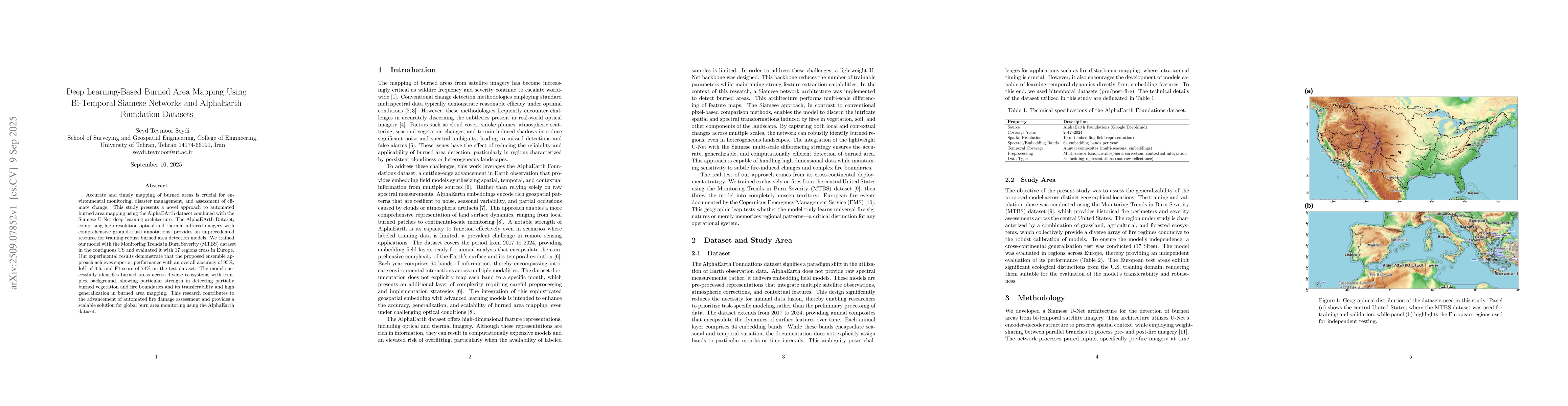
and evaluated it with 17 regions cross in Europe. Our experimental results demonstrate that the proposed ensemble approach achieves superior performance with an overall accuracy of 95%, IoU of 0.6, and F1-score of 74% on the test dataset. The model successfully identifies burned areas across diverse ecosystems with complex background, showing particular strength in detecting partially burned vegetation and fire boundaries and its transferability and high generalization in burned area mapping. This research contributes to the advancement of automated fire damage assessment and provides a scalable solution for global burn area monitoring using the AlphaEarth dataset.
Key Findings, in focus
Seven facets of this paper, analysed and brought into focus by AI.
This research advances automated fire damage assessment and provides a scalable solution for global burned area monitoring, leveraging the AlphaEarth dataset for improved accuracy and efficiency in environmental monitoring and disaster management.
- The model achieved an overall accuracy of 95%, IoU of 0.6, and F1-score of 74% on the test dataset.
- It successfully identifies burned areas across diverse ecosystems, particularly excelling in detecting partially burned vegetation and fire boundaries.
- The model demonstrates strong transferability and generalization across different regions.
This research advances automated fire damage assessment and provides a scalable solution for global burned area monitoring, leveraging the AlphaEarth dataset for improved accuracy and efficiency in environmental monitoring and disaster management.
Development of a Siamese U-Net architecture with shared convolutional weights for bi-temporal analysis, combined with a hybrid loss function addressing class imbalance in burned area mapping.
The integration of bi-temporal Siamese networks with the AlphaEarth dataset offers a novel approach for accurate and scalable burned area detection, distinguishing it from traditional methods by leveraging temporal feature extraction and advanced deep learning techniques.
- False alarms persist in agricultural regions due to spectral similarities with crop cycles.
- Challenges in detecting fragmented burn patterns and gradual severity transitions due to binary classification limitations.
- Implementing multi-class severity classification to capture fire impact intricacies.
- Expanding training data to include fires from multiple continents for enhanced global applicability.
- Incorporating explainable AI techniques to identify key spectral bands contributing to detection accuracy.
Discussion 0