Deep Learning Model Transfer in Forest Mapping using Multi-source Satellite SAR and Optical Images
Publication
Metrics
AI Quick Summary
This study explores the use of transfer learning to adapt a deep learning model (SeUNet) for forest mapping across different regions using multi-source satellite data. The model, pre-trained in Finnish Lapland, achieved superior accuracy in Southern Finland, demonstrating the potential of deep learning model transfer for forest variable prediction.
Paper Preview
Abstract
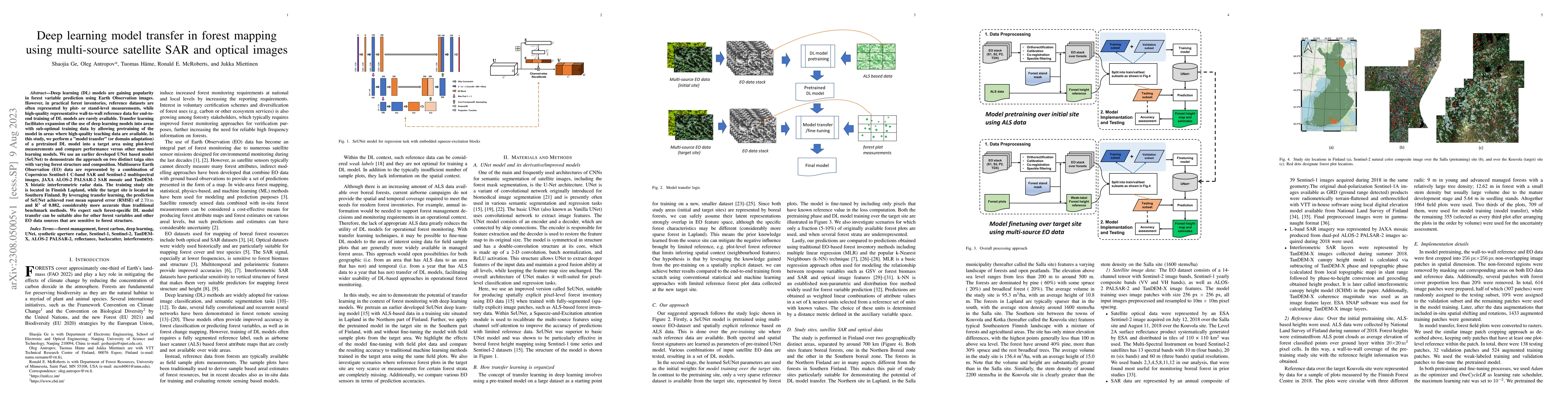
Deep learning (DL) models are gaining popularity in forest variable prediction using Earth Observation images. However, in practical forest inventories, reference datasets are often represented by plot- or stand-level measurements, while high-quality representative wall-to-wall reference data for end-to-end training of DL models are rarely available. Transfer learning facilitates expansion of the use of deep learning models into areas with sub-optimal training data by allowing pretraining of the model in areas where high-quality teaching data are available. In this study, we perform a "model transfer" (or domain adaptation) of a pretrained DL model into a target area using plot-level measurements and compare performance versus other machine learning models. We use an earlier developed UNet based model (SeUNet) to demonstrate the approach on two distinct taiga sites with varying forest structure and composition. Multisource Earth Observation (EO) data are represented by a combination of Copernicus Sentinel-1 C-band SAR and Sentinel-2 multispectral images, JAXA ALOS-2 PALSAR-2 SAR mosaic and TanDEM-X bistatic interferometric radar data. The training study site is located in Finnish Lapland, while the target site is located in Southern Finland. By leveraging transfer learning, the prediction of SeUNet achieved root mean squared error (RMSE) of 2.70 m and R$^2$ of 0.882, considerably more accurate than traditional benchmark methods. We expect such forest-specific DL model transfer can be suitable also for other forest variables and other EO data sources that are sensitive to forest structure.
AI Key Findings
Get AI-generated insights about this paper's methodology, results, significance, and more — seven facets brought into focus.
Impact
Paper Details
Authors
PDF Preview
Key Terms
Citation Network
Current paper (gray), citations (green), references (blue)
Display is limited for performance on very large graphs.
Discussion 0