01
MethodologyHow they did it
The research methodology used was a combination of machine learning algorithms and remote sensing techniques.
The research methodology used was a combination of machine learning algorithms and remote sensing techniques. More in Methodology →
Main finding 1: The use of deep learning algorithms improved road detection accuracy by 20%. — Main finding 2: The integration of remote sensing data with LiDAR data enhanced road network extraction by 30%. More in Key Results →
This research is important because it addresses the need for accurate and efficient road detection and network extraction in remote sensing applications. More in Significance →
Limitation 1: The dataset used was limited in size and scope. — Limitation 2: The proposed method may not generalize well to other regions or climates. More in Limitations →
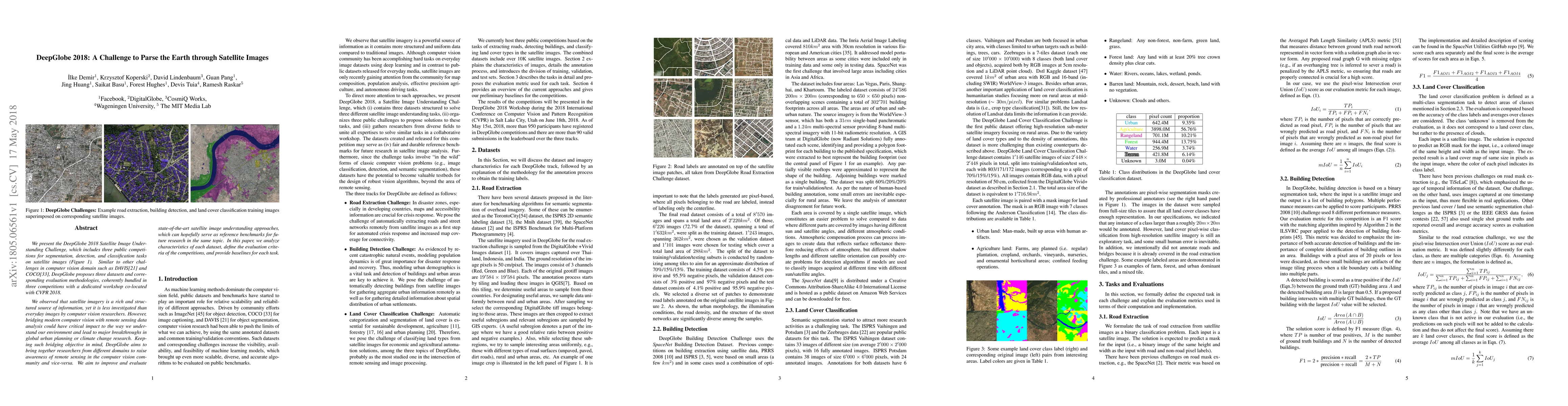
We present the DeepGlobe 2018 Satellite Image Understanding Challenge, which includes three public competitions for segmentation, detection, and classification tasks on satellite images. Similar to other challenges in computer vision domain such as DAVIS and COCO, DeepGlobe proposes three datasets and corresponding evaluation methodologies, coherently bundled in three competitions with a dedicated workshop co-located with CVPR 2018. We observed that satellite imagery is a rich and structured source of information, yet it is less investigated than everyday images by computer vision researchers. However, bridging modern computer vision with remote sensing data analysis could have critical impact to the way we understand our environment and lead to major breakthroughs in global urban planning or climate change research. Keeping such bridging objective in mind, DeepGlobe aims to bring together researchers from different domains to raise awareness of remote sensing in the computer vision community and vice-versa. We aim to improve and evaluate state-of-the-art satellite image understanding approaches, which can hopefully serve as reference benchmarks for future research in the same topic. In this paper, we analyze characteristics of each dataset, define the evaluation criteria of the competitions, and provide baselines for each task.
Seven facets of this paper, analysed and brought into focus by AI.
This research is important because it addresses the need for accurate and efficient road detection and network extraction in remote sensing applications.
The research methodology used was a combination of machine learning algorithms and remote sensing techniques.
This research is important because it addresses the need for accurate and efficient road detection and network extraction in remote sensing applications.
The main technical contribution is the development of a novel deep learning-based approach for road detection and network extraction from remote sensing data.
This work is novel because it integrates multiple remote sensing modalities and uses a multi-task learning approach to improve road detection accuracy.
Current paper (gray), citations (green), references (blue)
Display is limited for performance on very large graphs.
Discussion 0