Publication

Published: Jan 30, 2026
Categories: cs.CV

Metrics

Source: ArXiv

Quick Actions

View PDF

Quick Answers

What methodology did the authors use?

The research introduces a diachronic stereo matching method for satellite imagery, combining fine-tuning of a state-of-the-art deep stereo network (MonSter) with a dataset of diachronic image pairs. The approach involves rectification of image pairs, monocular depth priors, and iterative refinement of disparity estimates. More in Methodology →

What are the key results?

The method outperforms classical pipelines and unadapted deep stereo models on both synchronic and diachronic settings. — Fine-tuning on temporally diverse images with monocular priors enables accurate 3D reconstruction from previously incompatible acquisition dates. More in Key Results →

Why is this work significant?

This research addresses the challenge of 3D reconstruction from temporally distant satellite imagery, which is critical for applications like environmental monitoring and urban planning where seasonal changes are common. It bridges the gap between classical and deep learning approaches for stereo matching. More in Significance →

What are the main limitations?

The model exhibits vegetation bias, predicting higher disparities for trees even when they are not visible in both images. — Reduced sharpness in predicted disparities due to training data derived from LiDAR measurements with limited spatial resolution. More in Limitations →

Paper Preview

Abstract

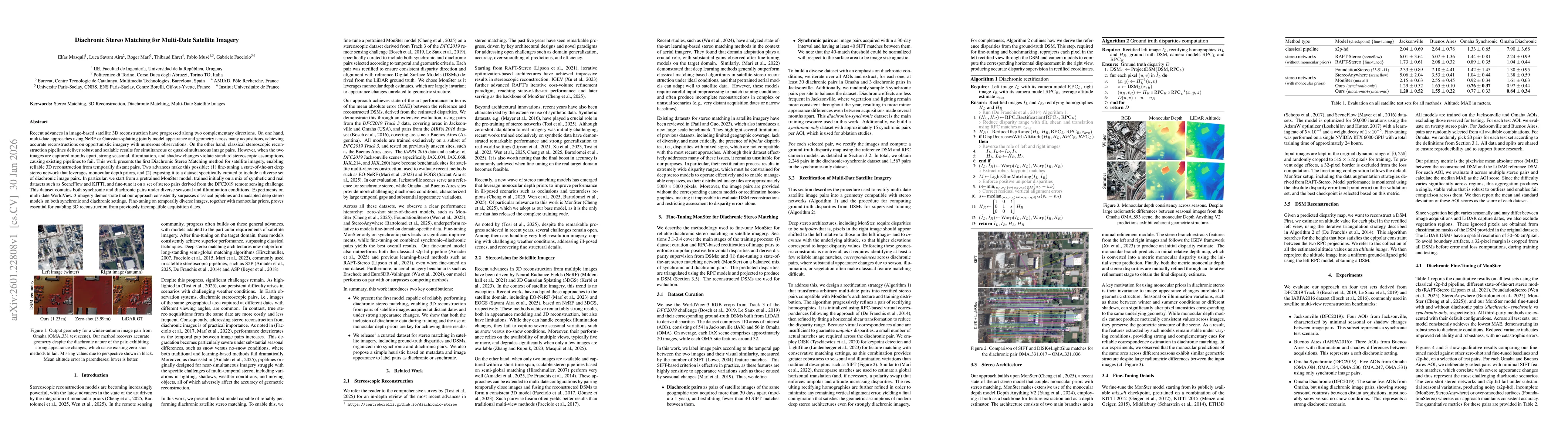
Recent advances in image-based satellite 3D reconstruction have progressed along two complementary directions. On one hand, multi-date approaches using NeRF or Gaussian-splatting jointly model appearance and geometry across many acquisitions, achieving accurate reconstructions on opportunistic imagery with numerous observations. On the other hand, classical stereoscopic reconstruction pipelines deliver robust and scalable results for simultaneous or quasi-simultaneous image pairs. However, when the two images are captured months apart, strong seasonal, illumination, and shadow changes violate standard stereoscopic assumptions, causing existing pipelines to fail. This work presents the first Diachronic Stereo Matching method for satellite imagery, enabling reliable 3D reconstruction from temporally distant pairs. Two advances make this possible: (1) fine-tuning a state-of-the-art deep stereo network that leverages monocular depth priors, and (2) exposing it to a dataset specifically curated to include a diverse set of diachronic image pairs. In particular, we start from a pretrained MonSter model, trained initially on a mix of synthetic and real datasets such as SceneFlow and KITTI, and fine-tune it on a set of stereo pairs derived from the DFC2019 remote sensing challenge. This dataset contains both synchronic and diachronic pairs under diverse seasonal and illumination conditions. Experiments on multi-date WorldView-3 imagery demonstrate that our approach consistently surpasses classical pipelines and unadapted deep stereo models on both synchronic and diachronic settings. Fine-tuning on temporally diverse images, together with monocular priors, proves essential for enabling 3D reconstruction from previously incompatible acquisition dates. Left image (winter) Right image (autumn) DSM geometry Ours (1.23 m) Zero-shot (3.99 m) LiDAR GT Figure 1. Output geometry for a winter-autumn image pair from Omaha (OMA 331 test scene). Our method recovers accurate geometry despite the diachronic nature of the pair, exhibiting strong appearance changes, which cause existing zero-shot methods to fail. Missing values due to perspective shown in black. Mean altitude error in parentheses; lower is better.

AI Key Findings

Generated Feb 02, 2026

Methodology — What approach did the authors take?

The research introduces a diachronic stereo matching method for satellite imagery, combining fine-tuning of a state-of-the-art deep stereo network (MonSter) with a dataset of diachronic image pairs. The approach involves rectification of image pairs, monocular depth priors, and iterative refinement of disparity estimates.

Key Results — What are the main findings?

  • The method outperforms classical pipelines and unadapted deep stereo models on both synchronic and diachronic settings.
  • Fine-tuning on temporally diverse images with monocular priors enables accurate 3D reconstruction from previously incompatible acquisition dates.
  • The approach achieves mean altitude errors of 1.23m for winter-autumn image pairs, significantly better than zero-shot methods (3.99m).

Significance — Why does this research matter?

This research addresses the challenge of 3D reconstruction from temporally distant satellite imagery, which is critical for applications like environmental monitoring and urban planning where seasonal changes are common. It bridges the gap between classical and deep learning approaches for stereo matching.

Technical Contribution — What is the technical contribution?

Development of a fine-tuned deep stereo network (MonSter) that incorporates monocular depth priors and is trained on a dataset with both synchronic and diachronic satellite image pairs.

Novelty — What is new about this work?

The novelty lies in the first diachronic stereo matching method for satellite imagery, combining monocular depth priors with fine-tuning on temporally diverse data to enable reliable 3D reconstruction from previously incompatible acquisition dates.

Limitations — What are the limitations of this study?

  • The model exhibits vegetation bias, predicting higher disparities for trees even when they are not visible in both images.
  • Reduced sharpness in predicted disparities due to training data derived from LiDAR measurements with limited spatial resolution.

Future Work — What did the authors propose for future work?

  • Exploring synthetic data to mitigate biases and improve sharpness of disparity predictions.
  • Enhancing temporal alignment between satellite imagery and LiDAR data to reduce temporal discordance.
  • Investigating the use of more diverse and temporally rich datasets for further improving diachronic stereo matching performance.

Paper Details

Paper ID: 2601.22808
Journal: ISPRS congress, ISPRS, Jul 2026, Toronto, Canada
Categories:
cs.CV

How to Cite This Paper

BibTeX
@article{masquil2026diachronic,
  title         = {Diachronic Stereo Matching for Multi-Date Satellite Imagery},
  author        = {Masquil, Elías and Facciolo, Gabriele and Aira, Luca Savant and others},
  year          = {2026},
  eprint        = {2601.22808},
  archivePrefix = {arXiv},
  primaryClass  = {cs.CV},
}
APA 7
Masquil, E., Facciolo, G., Aira, L., Musé, P., Marí, R., & Ehret, T. (2026). Diachronic Stereo Matching for Multi-Date Satellite Imagery. arXiv. https://arxiv.org/abs/2601.22808
MLA 9
Masquil, Elías, et al. "Diachronic Stereo Matching for Multi-Date Satellite Imagery." arXiv, 2026, arxiv.org/abs/2601.22808.

Comments (0)

This website uses cookies to ensure you get the best experience. Learn more