Digital Elevation Model enhancement using Deep Learning

Source: ArXiv

AI Quick Summary

This paper presents a deep learning approach using convolutional neural networks to significantly enhance planetary digital elevation models (DEMs) by leveraging optical images, achieving a 90x resolution improvement for global Mars DEMs and demonstrating comparable accuracy to traditional methods. The method is scalable and can be applied globally with automation.

Share: Share on X LinkedIn

Summary

We demonstrate high fidelity enhancement of planetary digital elevation models (DEMs) using optical images and deep learning with convolutional neural networks. Enhancement can be applied recursively to the limit of available optical data, representing a 90x resolution improvement in global Mars DEMs. Deep learning-based photoclinometry robustly recovers features obscured by non-ideal lighting conditions. Method can be automated at global scale. Analysis shows enhanced DEM slope errors are comparable with high resolution maps using conventional, labor intensive methods.

AI Key Findings

Generated Sep 03, 2025

Methodology

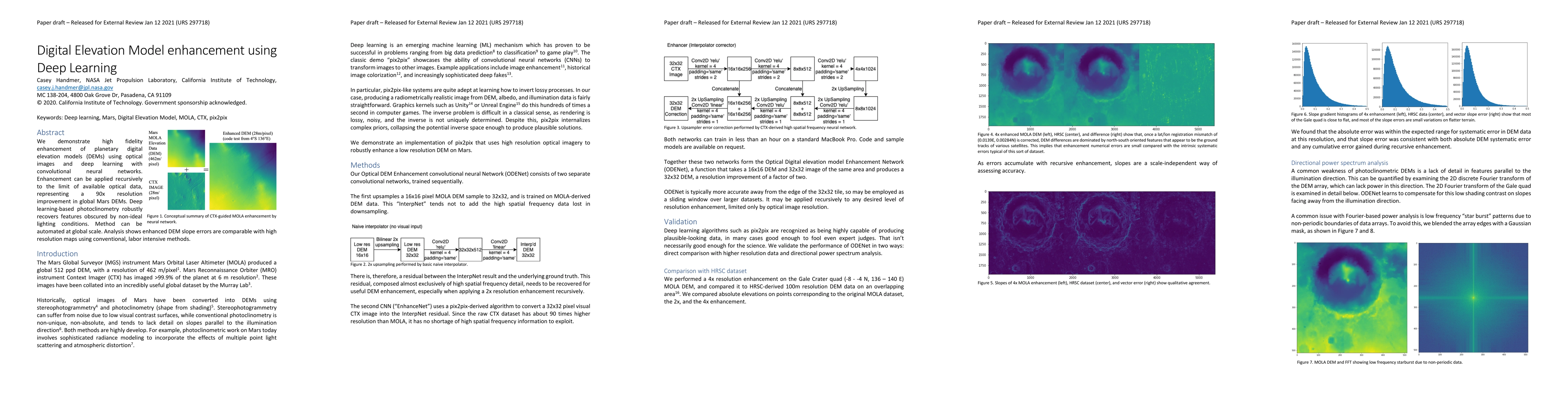
The research employs deep learning with convolutional neural networks (CNNs) to enhance planetary digital elevation models (DEMs) using optical images. The method, named ODENet, can be recursively applied to improve resolution, demonstrated with a 90x improvement for global Mars DEMs.

Key Results

  • ODENet successfully enhances DEMs with a 90x resolution improvement for global Mars datasets.
  • Enhanced DEMs show comparable slope errors to high-resolution maps generated by conventional, labor-intensive methods.
  • The method robustly recovers features obscured by non-ideal lighting conditions, addressing a common weakness in photoclinometry.
  • Recursive enhancement allows for automated global-scale application of the technique.
  • ODENet learns to compensate for low shading contrast on slopes facing away from the illumination direction.

Significance

This research is significant as it presents an automated, deep learning-based method for enhancing DEMs, which can be applied globally. The method improves resolution significantly while maintaining accuracy comparable to labor-intensive methods, potentially revolutionizing the generation of high-resolution DEMs for planetary surfaces.

Technical Contribution

The main technical contribution is the development and application of ODENet, a deep learning model that recursively enhances DEMs using optical images, addressing issues related to low shading contrast and non-ideal lighting conditions.

Novelty

This work is novel as it combines deep learning techniques with photoclinometry to enhance DEMs, offering an automated solution that significantly improves resolution while maintaining accuracy, unlike conventional labor-intensive methods.

Limitations

  • The study is limited to Mars datasets, and its applicability to other planetary bodies remains to be explored.
  • The method's performance may vary with different types of optical imagery and terrain characteristics.

Future Work

  • Extend the ODENet method to other planetary bodies like the Moon, Europa, or Titan.
  • Investigate the performance of ODENet with diverse optical imagery types and terrain conditions.

Paper Details

PDF Preview

Download PDF

Key Terms

enhancement (0.253)
deep learning (0.235)
global (0.200)
resolution (0.198)
optical (0.192)
deep (0.192)
intensive (0.181)
high fidelity (0.181)

Citation Network

Current paper (gray), citations (green), references (blue)

Display is limited for performance on very large graphs.

Current Paper
Citations
References
Click to view

No citations found for this paper.

Comments (0)

This website uses cookies to ensure you get the best experience. Learn more