Summary

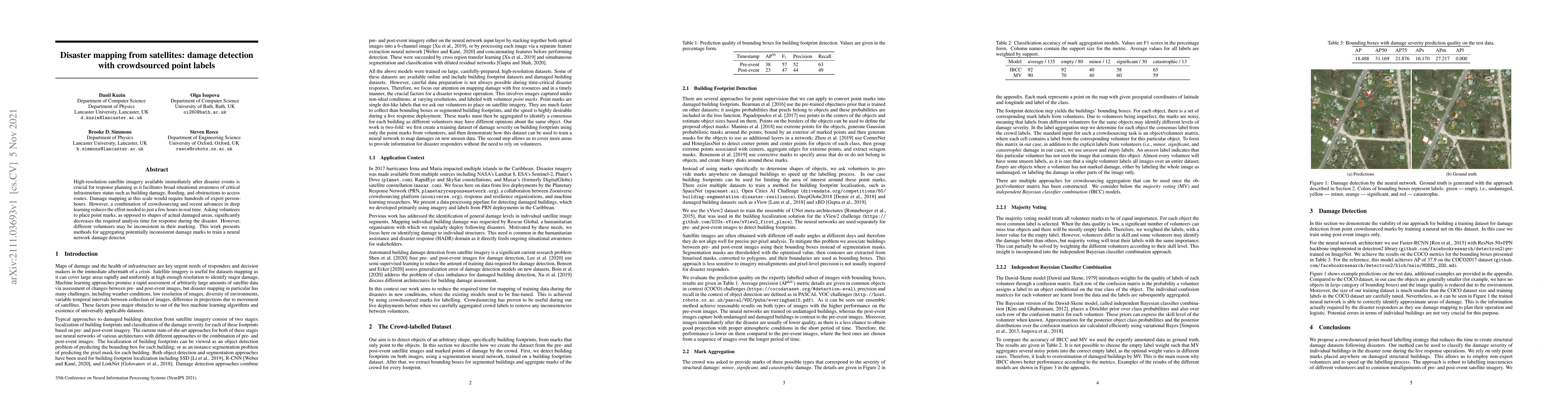
High-resolution satellite imagery available immediately after disaster events is crucial for response planning as it facilitates broad situational awareness of critical infrastructure status such as building damage, flooding, and obstructions to access routes. Damage mapping at this scale would require hundreds of expert person-hours. However, a combination of crowdsourcing and recent advances in deep learning reduces the effort needed to just a few hours in real time. Asking volunteers to place point marks, as opposed to shapes of actual damaged areas, significantly decreases the required analysis time for response during the disaster. However, different volunteers may be inconsistent in their marking. This work presents methods for aggregating potentially inconsistent damage marks to train a neural network damage detector.

AI Key Findings

Generated Sep 03, 2025

Methodology

The research utilizes crowdsourcing for damage marking in satellite imagery post-disaster, combined with deep learning techniques to train a neural network for damage detection, significantly reducing the time required from hundreds of expert person-hours to just a few hours.

Key Results

  • Crowdsourced point labels significantly decrease required analysis time for disaster response.
  • Inconsistent volunteer marks can be aggregated using methods to train a neural network damage detector effectively.
  • Independent Bayesian Classifier Combination (IBCC) model outperforms Majority Voting (MV) in aggregating crowd labels for damage severity.

Significance

This research is crucial for disaster response planning as it provides a rapid method for situational awareness of critical infrastructure status, enabling quicker and more efficient allocation of resources.

Technical Contribution

The paper presents methods for aggregating inconsistent crowdsourced damage marks and trains a neural network for damage detection, demonstrating the viability of this approach for building damage datasets.

Novelty

The work combines crowdsourcing with deep learning to address the challenge of rapid damage assessment from satellite imagery post-disaster, offering a novel solution that reduces reliance on expert personnel.

Limitations

  • Volunteer marks can be inconsistent due to varying skill levels and visibility of damage in satellite imagery.
  • The method relies on the availability of volunteers and internet access for crowdsourcing.

Future Work

  • Explore methods to further improve the accuracy of crowdsourced labels.
  • Investigate the scalability of the approach for larger disaster events and diverse geographical regions.

Paper Details

PDF Preview

Download PDF

Key Terms

inconsistent (0.270)
hours (0.266)
hours (0.263)
response (0.203)
response (0.195)
awareness (0.172)
routes (0.171)
person (0.171)

Citation Network

Current paper (gray), citations (green), references (blue)

Display is limited for performance on very large graphs.

Current Paper
Citations
References
Click to view
Title Authors Year Actions

Comments (0)

This website uses cookies to ensure you get the best experience. Learn more